Dexter City, Ohio

Last updated

Dexter City, Ohio
Dexter City UMC.jpg
Methodist church
OHMap-doton-Dexter City.png
Location of Dexter City, Ohio
Map of Noble County Ohio Highlighting Dexter City Village.png
Location of Dexter City in Noble County
Coordinates: 39°39′33″N81°28′26″W / 39.65917°N 81.47389°W / 39.65917; -81.47389
Country United States
State Ohio
County Noble
Area
[1]
  Total0.17 sq mi (0.45 km2)
  Land0.17 sq mi (0.43 km2)
  Water0.01 sq mi (0.02 km2)
Elevation
[2]
742 ft (226 m)
Population
 (2020)
  Total81
  Density485.03/sq mi (187.66/km2)
Time zone UTC-5 (Eastern (EST))
  Summer (DST) UTC-4 (EDT)
ZIP code
45727
Area code 740
FIPS code 39-21910 [3]
GNIS feature ID2398720 [2]

Dexter City is a village in Noble County, Ohio, United States, along the West Fork of Duck Creek. The population was 81 at the 2020 census. Dexter City was laid out in 1870, and named after Dexter W. Sullivan, an early settler. [4]

Contents

Geography

According to the United States Census Bureau, the village has a total area of 0.2 square miles (0.5 km2), all of it land.

Demographics

Historical population
CensusPop.Note
1880 255
1890 217−14.9%
1900 27828.1%
1910 235−15.5%
1920 212−9.8%
1930 209−1.4%
1940 191−8.6%
1950 170−11.0%
1960 19715.9%
1970 178−9.6%
1980 173−2.8%
1990 161−6.9%
2000 1663.1%
2010 129−22.3%
2020 81−37.2%
U.S. Decennial Census [5]

2010 census

As of the census [6] of 2010, there were 129 people, 51 households, and 36 families living in the village. The population density was 758.8 inhabitants per square mile (293.0/km2). There were 56 housing units at an average density of 329.4 per square mile (127.2/km2). The racial makeup of the village was 95.3% White, 0.8% African American, and 3.9% from two or more races.

There were 51 households, of which 31.4% had children under the age of 18 living with them, 51.0% were married couples living together, 13.7% had a female householder with no husband present, 5.9% had a male householder with no wife present, and 29.4% were non-families. 25.5% of all households were made up of individuals, and 9.8% had someone living alone who was 65 years of age or older. The average household size was 2.53 and the average family size was 2.97.

The median age in the village was 38.5 years. 27.1% of residents were under the age of 18; 7.1% were between the ages of 18 and 24; 24.9% were from 25 to 44; 30.3% were from 45 to 64; and 10.9% were 65 years of age or older. The gender makeup of the village was 49.6% male and 50.4% female.

2000 census

As of the census [3] of 2000, there were 166 people, 63 households, and 45 families living in the village. The population density was 948.4 inhabitants per square mile (366.2/km2). There were 66 housing units at an average density of 377.1 per square mile (145.6/km2). The racial makeup of the village was 100.00% White.

There were 63 households, out of which 39.7% had children under the age of 18 living with them, 49.2% were married couples living together, 17.5% had a female householder with no husband present, and 27.0% were non-families. 23.8% of all households were made up of individuals, and 11.1% had someone living alone who was 65 years of age or older. The average household size was 2.63 and the average family size was 3.04.

In the village, the population was spread out, with 29.5% under the age of 18, 7.2% from 18 to 24, 30.7% from 25 to 44, 24.1% from 45 to 64, and 8.4% who were 65 years of age or older. The median age was 35 years. For every 100 females there were 102.4 males. For every 100 females age 18 and over, there were 82.8 males.

The median income for a household in the village was $30,469, and the median income for a family was $35,000. Males had a median income of $31,250 versus $23,750 for females. The per capita income for the village was $11,881. About 18.2% of families and 21.6% of the population were below the poverty line, including 21.6% of those under the age of eighteen and 28.6% of those 65 or over.

Related Research Articles

Garland is a town in Penobscot County, Maine, United States. The population was 1,026 at the 2020 census.

<span class="mw-page-title-main">Ionia, Michigan</span> Largest city and the county seat of Ionia County, Michigan, United States

Ionia is the largest city in, and the county seat of, Ionia County, Michigan, United States. The population was 13,378 at the 2020 census. Every July it hosts what is said to be the world's largest free-admission fair, the Ionia Free Fair. The city is mostly within Ionia Township, with small portion extending into Easton Township and Berlin Township, but is politically autonomous of the townships. The city is named after Ionia, a historic region in Greece.

<span class="mw-page-title-main">Mussey Township, Michigan</span> Civil township in Michigan, United States

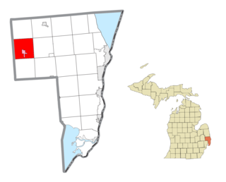
Mussey Township is a civil township of St. Clair County in the U.S. state of Michigan. The population was 4,234 at the 2020 Census.

<span class="mw-page-title-main">Dexter, Minnesota</span> City in Minnesota, United States

Dexter is a city Mower County, Minnesota, United States. The population was 324 at the 2020 census.

<span class="mw-page-title-main">Marlborough, Missouri</span> Village in Missouri, United States

Marlborough is a village in St. Louis County, Missouri, United States. The population was 2,179 at the 2010 census.

<span class="mw-page-title-main">Dexter, Missouri</span> City in Missouri, United States

Dexter is a city in Stoddard County, Missouri, United States, founded in 1873. The population was 7,864 at the 2010 census.

<span class="mw-page-title-main">Dudley, Missouri</span> City in Missouri, United States

Dudley is a city in Stoddard County, Missouri, United States. The population was 232 at the 2010 census.

<span class="mw-page-title-main">Uplands Park, Missouri</span> Village in Missouri, United States

Uplands Park is a village in St. Louis County, Missouri, United States. The population was 445 at the 2010 census. The village is one of many small majority black communities located in the Natural Bridge corridor of mid-St. Louis County, characterized by small homes on small lots.

<span class="mw-page-title-main">Dexter, New York</span> Village in New York, United States

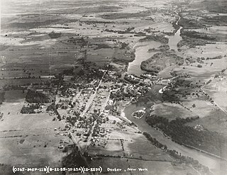
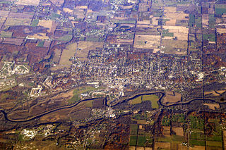
Dexter is a village in Jefferson County, New York, United States. The population was 1,052 at the 2010 census. The name is derived from Simon Newton Dexter, one of the village's stockholders.

<span class="mw-page-title-main">Nellie, Ohio</span> Village in Ohio, United States

Nellie is a village in Coshocton County, Ohio, United States, along the Walhonding River. The population was 122 at the 2020 census.

<span class="mw-page-title-main">Cuyahoga Heights, Ohio</span> Village in Ohio, United States

Cuyahoga Heights is a village in Cuyahoga County, Ohio, United States. The population was 573 at the 2020 census. A suburb of Cleveland, it is a part of the Cleveland metropolitan area.

<span class="mw-page-title-main">Walton Hills, Ohio</span> Village in Ohio, United States

Walton Hills is a village in Cuyahoga County, Ohio, United States. The population was 2,033 at the 2020 census. A suburb of Cleveland, it is a part of the Cleveland metropolitan area.

<span class="mw-page-title-main">Gordon, Ohio</span> Village in Ohio, United States

Gordon is a village in Darke County, Ohio, United States. The population was 245 at the 2020 census.

<span class="mw-page-title-main">Wayne Lakes, Ohio</span> Village in Ohio, United States

Wayne Lakes is a village in Darke County, Ohio, United States. The population was 693 at the 2020 census.

<span class="mw-page-title-main">Valleyview, Ohio</span> Village in Ohio, United States

Valleyview is a village in Franklin County, Ohio, United States. The population was 669 at the 2020 census.

<span class="mw-page-title-main">Addyston, Ohio</span> Village in Ohio, United States

Addyston is a village in Miami Township, Hamilton County, Ohio, United States. Located along the Ohio River, it is a western suburb of the neighboring city of Cincinnati. The population was 927 at the 2020 census.

<span class="mw-page-title-main">Hartville, Ohio</span> Village in Ohio, United States

Hartville is a village in northern Stark County, Ohio, United States. The population was 3,329 at the 2020 census. It is part of the Canton–Massillon metropolitan area. Hartville lies halfway between Akron and Canton at the intersection of State Routes 43 and 619.

<span class="mw-page-title-main">Kekoskee, Wisconsin</span> Village in Wisconsin, United States

Kekoskee is a village in Dodge County, Wisconsin, United States. The population was 161 at the 2010 census.

<span class="mw-page-title-main">Avoca, Wisconsin</span> Village in Wisconsin, United States

Avoca is a village in Iowa County, Wisconsin, United States. The population was 637 at the 2010 census. It is part of the Madison Metropolitan Statistical Area. It is named after Avoca in Ireland.

<span class="mw-page-title-main">Patch Grove, Wisconsin</span> Village in Wisconsin, United States

Patch Grove is a village in Grant County, Wisconsin, United States. The population was 198 at the 2010 census. The village is located within the Town of Patch Grove.

References

  1. "ArcGIS REST Services Directory". United States Census Bureau. Retrieved September 20, 2022.
  2. 1 2 U.S. Geological Survey Geographic Names Information System: Dexter City, Ohio
  3. 1 2 "U.S. Census website". United States Census Bureau . Retrieved January 31, 2008.
  4. Overman, William Daniel (1958). Ohio Town Names. Akron, OH: Atlantic Press. p. 38.
  5. "Census of Population and Housing". Census.gov. Retrieved June 4, 2015.
  6. "U.S. Census website". United States Census Bureau . Retrieved January 6, 2013.