
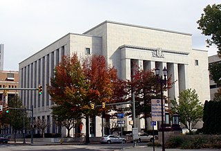
Harrisburg is the capital city of the Commonwealth of Pennsylvania, United States, and the county seat of Dauphin County. With a population of 50,135 as of the 2021 census, Harrisburg is the 15th largest municipality in Pennsylvania.

Elizabethtown is a borough in Lancaster County, Pennsylvania. It is located 18 miles (29 km) southeast of Harrisburg, the state capital. Small factories existed at the turn of the 20th century when the population in 1900 was 1,861. As of the 2020 census, the population of the borough was 11,639. Elizabethtown is commonly referred to in south-central Pennsylvania as "E-Town." This nickname is also used for the local college and high school.
Dauphin County is a county in the Commonwealth of Pennsylvania. As of the 2020 census, the population was 286,401. The county seat and the largest city is Harrisburg, Pennsylvania's state capital and ninth largest city. The county was created ("erected") on March 4, 1785, from part of Lancaster County and was named after Louis Joseph, Dauphin of France, the first son of King Louis XVI.

Enola is a census-designated place (CDP) located along the Susquehanna River in East Pennsboro Township, Cumberland County, Pennsylvania. The population was 6,111 at the 2010 census. Norfolk Southern operates Enola Yard, a large rail yard and locomotive shop in Enola. It is situated in Cumberland County, directly across the Susquehanna River from Harrisburg and is part of the Harrisburg–Carlisle metropolitan statistical area.

Dauphin is a borough in Dauphin County, Pennsylvania. The population was 796 at the 2020 census. Dauphin's ZIP code is 17018. It is part of the Harrisburg–Carlisle Metropolitan Statistical Area.

Lower Paxton Township is a township of the second class in Dauphin County, Pennsylvania. The population was 53,501 at the 2020 census. It is the most populous municipality in Dauphin County, exceeding that of Harrisburg, the state capital, and the 13th most populated municipality in the state.

Lower Swatara Township is a township in Dauphin County, Pennsylvania. The population was 9,557 at the 2020 census. Harrisburg International Airport and Penn State Harrisburg are located within the township. It shares a ZIP Code with the nearby borough of Middletown, and all locations in the township have Middletown addresses.

Penbrook is a borough in Dauphin County, Pennsylvania, United States, founded in 1861 and incorporated July 10, 1894. Penbrook was once named East Harrisburg and still maintains a Harrisburg postal ZIP code. The population was 3,268 at the 2020 census.
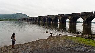
Susquehanna Township is a township in Dauphin County, Pennsylvania. The population was 26,736 at the time of the 2020 census. This represents a 9.8% increase from the 2000 census count of 21,895. Susquehanna Township has the postal ZIP codes 17109 and 17110, which maintain the Harrisburg place name designation. The township is a suburb of Harrisburg and is connected to Marysville by the Rockville Bridge, the world's longest stone-arch rail bridge at the time of its completion.

Williamsport is a city in, and the county seat of, Lycoming County, Pennsylvania, United States. It recorded a population of 27,754 at the 2020 Census. It is the principal city of the Williamsport Metropolitan Statistical Area, which has a population of about 114,000. Williamsport is the larger principal city of the Williamsport-Lock Haven, PA Combined Statistical Area, which includes Lycoming and Clinton Counties.
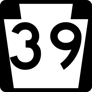
Pennsylvania Route 39 (PA 39) is a 17.83-mile-long (28.69 km) state highway located in Dauphin County, Pennsylvania, United States. PA 39 runs from North Front Street near Harrisburg east to U.S. Route 322 (US 322) and US 422 near Hummelstown and Hershey. The route passes through the northern and eastern suburbs of Harrisburg and passes by Hersheypark, Giant Center, as well as the primary production factory for The Hershey Company. Between Harrisburg and Manada Hill, it is known as Linglestown Road, from Manada Hill to Hershey as Hershey Road and from Hershey to near Hummelstown and Hershey as Hersheypark Drive. Prior to the establishment of PA 39 in 1937, PA 39, had previously been designated as a route in northeastern Pennsylvania during the 1920s. That designation was deleted when it was renumbered US 11. As a result, PA 39 is one of a few routes which has a set of child routes which are no where near the primary route.

Upper Pine Bottom State Park is a 5-acre (2.0 ha) Pennsylvania state park in Lycoming County, Pennsylvania in the United States. The park is in Cummings Township on Pennsylvania Route 44 and is surrounded by the Tiadaghton State Forest. It is on Upper Pine Bottom Run, which gave the park its name and is a tributary of Pine Creek. Upper Pine Bottom State Park is in the Pine Creek Gorge, where the streams have cut through five major rock formations from the Devonian and Carboniferous periods.

Paxton Creek is a 13.9-mile-long (22.4 km) tributary of the Susquehanna River in Dauphin County, Pennsylvania in the United States.

The Capital Area Greenbelt is a looping trail located in the area of Harrisburg, Pennsylvania. This 20-mile loop around Pennsylvania's capital city provides visitors and tourists with opportunities to hike, ride bicycles, skate, jog, fish, walk their dogs, spot rare birds, learn about history, enjoy native flora and fauna, and appreciate nature. While parts of the trail are shared with roads, most of the loop is a dedicated path. The Trail, as it is commonly referred to by locals, passes along the Susquehanna River through Reservoir Park, Riverfront Park, Five Senses Garden, and Wildwood Park and Nature Center. In addition to parks, the Capital Area Greenbelt passes alongside attractions including the grave site of John Harris Sr., the Governor's Mansion, Fort Hunter, Harrisburg State Hospital, and the National Civil War Museum.

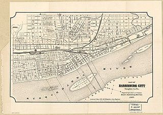
The history of Harrisburg, the state capital of the Commonwealth of Pennsylvania, United States, has played a key role in the development of the nation's industrial history from its origins as a trading outpost to the present. Harrisburg has played a critical role in American history during the Westward Migration, the American Civil War, and the Industrial Revolution. For part of the 19th century, the building of the Pennsylvania Canal and later the Pennsylvania Railroad allowed Harrisburg to become one of the most industrialized cities in the Northeast.

U.S. Route 11 (US 11) roughly parallels Interstate 81 (I-81) in the U.S. state of Pennsylvania. The route runs from the Maryland state line in Antrim Township, Franklin County, northeast to the New York state line in Great Bend Township, Susquehanna County. US 11 serves Harrisburg, Wilkes-Barre, and Scranton. Between Harrisburg and Scranton, US 11 follows the Susquehanna River, while I-81 follows a shorter route over the mountains further to the east.
Estherton is an unincorporated area in Dauphin County, Pennsylvania, United States, and a part of the Harrisburg-Carlisle area. It is situated on the Susquehanna River, just north of the city of Harrisburg and above Montrose Park in Susquehanna Township. The area is served by the Harrisburg post office, with the zip code of 17110. Interstate 81 runs through the community to the George N. Wade Memorial Bridge.
This is a timeline of the major events in the history of Harrisburg, Pennsylvania and vicinity.

