
Harrisburg is the capital city of the Commonwealth of Pennsylvania, United States, and the county seat of Dauphin County. With a population of 50,135 as of the 2021 census, Harrisburg is the 15th largest municipality in Pennsylvania.

Midtown Manhattan is the central portion of the New York City borough of Manhattan and serves as the city's primary central business district. Midtown is home to some of the city's most prominent buildings, including the Empire State Building, the Chrysler Building, the Hudson Yards Redevelopment Project, the headquarters of the United Nations, Grand Central Terminal, and Rockefeller Center, as well as tourist destinations such as Broadway, Times Square, and Koreatown. Penn Station in Midtown Manhattan is the busiest transportation hub in the Western Hemisphere.
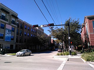
Midtown is a central neighborhood of Houston, located west-southwest of Downtown. Separated from Downtown by an elevated section of Interstate 45, Midtown is characterized by a continuation of Downtown's square grid street plan, anchored by Main Street and the METRORail Red Line. Midtown is bordered by Neartown (Montrose) to the west, the Museum District to the south, and Interstate 69 to the east. Midtown's 325 blocks cover 1.24 square miles (3.2 km2) and contained an estimated population of nearly 8,600 in 2015.

HACC, Central Pennsylvania's Community College, (HACC) is a community college in Harrisburg, Pennsylvania. HACC is accredited by the Commission on Higher Education of the Middle States Association of Colleges and Schools. HACC serves 17,000 degree-seeking students, as well as more than 8,300 remedial and workforce development students. The College has more than 100,000 alumni.

Uptown is a section of Harrisburg, Pennsylvania located North of the Midtown and Downtown neighborhoods.

Downtown Harrisburg is the central core neighborhood, business and government center which surrounds the focal point of Market Square, and serves as the regional center for the greater metropolitan area of Harrisburg, Pennsylvania, United States.

Camp Curtin is a historic neighborhood in Harrisburg, Pennsylvania's northern end, located in Uptown and named for the American Civil War camp of the same name. It is bordered currently by landmarks of Fifth Street to the west, the railroad tracks next to the Pennsylvania Farm Show Complex to the east, Maclay Street to the south, and Reels Lane to the North.

Midtown is a neighborhood in Harrisburg, Pennsylvania. Its zip code is 17102. The Midtown neighborhood is delineated by Forster Street to the south, Maclay Street to the north, 7th Street to the east, and the Susquehanna River to the west. Former Harrisburg Mayor William K. Verbeke is the namesake for Verbeke Street and first bought and developed the area. Midtown is home to the Pennsylvania Governor's Residence and the Broad Street Market, the oldest continually operated street market in the country.

Bellevue Park, is a neighborhood in East Harrisburg, Pennsylvania. It is known as Pennsylvania’s first fully planned residential community. Bellevue Park is characterized by winding lanes, wooded topography, underground utilities and period street lighting. Impressive mansions and open preserves are protected by stringent covenants.

The Old Uptown Historic District is a historic district in the Midtown neighborhood of Harrisburg, Pennsylvania. The district stretches from Reily to Maclay between Second and Third street. It consists of large Queen Anne and Italianate architecture built in the late 19th century and very early 20th century. The northern part of the historic district is currently being aggressively renovated by real estate investors.

The Old Midtown Historic District is a historic district in the Midtown neighborhood of Harrisburg, Pennsylvania. The district is located from Forster to Verbeke, and Front to Third street. It represents the first urbanized neighborhood in the city of Harrisburg. The Historic Harrisburg Association first lobbied for its creation in 1974. The area of Third street near Verbeke is known as the Historic Midtown Market District and is home to many unique boutiques, galleries and shops. Former Harrisburg Mayor William K. Verbeke is the namesake for Verbeke Street and first bought and developed the area.

Capitol Heights is a community of nearly 200 townhouse and single-family duplexes in the Midtown neighborhood of Harrisburg, Pennsylvania. Most of the new homes are located east of Third between Kelker and Reily and along Fulton, 4th and 5th street. The neighborhood is known for its generic suburban-style architecture fitted to the existing street grid. The area was previously referred to informally as "Lottsville" due to its many abandoned and vacant lots, so the City and private developers worked together in the 2000s as it was a targeted area for demolition and urban renewal.

Congregation Beth Israel of Houston, the oldest Jewish congregation in Texas, was founded in Houston in 1854. It operates the Shlenker School.
The Harrisburg Midtown Arts Center, alternatively the House of Music, Arts & Culture, is a multidisciplinary arts and cultural center located in Midtown Harrisburg, Pennsylvania. It is located in the historic Police Athletic League building, which originally served as a Jewish Community Center about one mile (1.6 km) from the Pennsylvania State Capitol complex.
Engleton is a section of the Midtown Harrisburg, Pennsylvania neighborhood. It is bounded by 2nd street to the west, Kelker Street to the north, 3rd street to the east and Reily Street to the south. Its Queen Anne style homes were built in the 1890s by Benjamin Engle, who is the namesake of the area. Market appeal for these homes was created by varying the colors and treatments of the façades.

The Marian Anderson House is a historic home located in the Southwest Center City neighborhood of Philadelphia, Pennsylvania. Built circa 1870 in the same neighborhood where opera singer and civil rights advocate Marian Anderson was born 27 years later, this two-story, brick rowhouse dwelling was designed in the Italianate style. Purchased by Anderson in 1924, the same year she became the first African-American concert artist to record spirituals for a major American recording company, she continued to reside here until 1943. The house is currently home to the Marian Anderson Museum and Historical Society.

Kesher Israel Congregation is an Orthodox synagogue in the Uptown neighborhood of Harrisburg, Pennsylvania, United States. Founded in 1902, it is officially affiliated with the Orthodox Union.

Midtown South is a macro-neighborhood of the borough of Manhattan in New York City, generally characterized as constituting the southern portion of Midtown Manhattan. Midtown Manhattan hosts over 700,000 daily employees as a busy hub for workers, residents, and tourists. The Empire State Building, the Flatiron Building, Pennsylvania Station, Madison Square Garden, the Macy's Herald Square flagship store, Koreatown, and NYU Langone Medical Center are all located in Midtown South.

Lower Westheimer is an area in Houston, Texas, United States. It is centered on Westheimer Road, and is considered to be East of Shepherd, and West of Midtown. Several historic neighborhoods are partially or completely located within the area including Montrose and Hyde Park. Lower Wertheimer is known for its hipster culture, nightlife, arts, and food scene.


