Essex County is a county in the U.S. state of New York. As of the 2020 census, the population was 37,381. Its county seat is the hamlet of Elizabethtown. Its name is from the English county of Essex. Essex is one of only 2 counties that are entirely within the Adirondack Park, the other being Hamilton County. The county is part of the North Country region of the state.

Au Sable Forks is a hamlet in Clinton County and Essex County, New York, United States. The northern half of the community, within Clinton County, is listed as the Au Sable Forks census-designated place (CDP) and had a population of 559 at the 2010 census.

Crown Point is a town in Essex County, New York, United States, located on the west shore of Lake Champlain. The population was 2,024 at the 2010 census. The name of the town is a direct translation of the original French name, Pointe à la Chevelure.

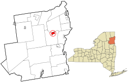
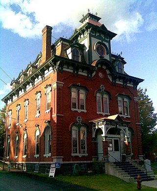
Elizabethtown is a town in Essex County, New York, United States. The population was 1,163 at the 2010 census. The county seat of Essex County is the hamlet of Elizabethtown, located in the northern part of the town. The name is derived from Elizabeth Gilliland, the wife of an early settler.
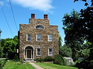
Essex is a town in Essex County, New York, United States overlooking Lake Champlain. The population was 621 at the 2020 census. The town is named after locations in England.

Jay is a town in Essex County, New York, United States. The population was 2,506 at the 2010 census. The town is named after John Jay, governor of New York when the town was formed.

Keene is a town in central Essex County, New York, United States. It includes the hamlets of Keene, Keene Valley, and St. Huberts, with a total population of 1,144 as of the 2020 census
Moriah is a town in Essex County, New York, United States. Lying within the Adirondack Park, it is situated in the eastern part of the county, 47 miles (76 km) by road south-southwest of Burlington, Vermont, 55 miles (89 km) south of Plattsburgh, 115 miles (185 km) north of Albany, and 116 miles (187 km) south of Montreal, Quebec. The population was 4,798 at the 2010 census.
North Elba is a town in Essex County, New York, United States. The population was 7,480 at the 2020 census.

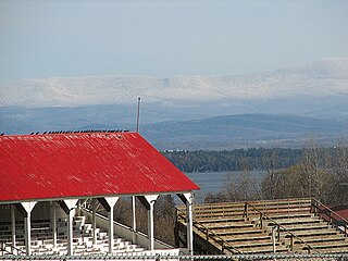
Schroon is a town in the Adirondack Park, in Essex County, New York, United States. The population was 1,880 at the 2020 census. The largest community in the town is the hamlet of Schroon Lake, located at the northern end of the lake of the same name.
Westport is a town in Essex County, New York, United States overlooking Lake Champlain. The population was 1,312 at the 2010 census.
Central Islip is a hamlet and census-designated place (CDP) within the Town of Islip in Suffolk County, New York, United States. The population was 34,450 at the 2010 census.
Keeseville is a hamlet in Clinton and Essex counties, New York, United States. The population was 1,815 at the 2010 census. The hamlet was named after the Keese family, early settlers from Vermont. It developed along the Ausable River, which provided water power for mills and industrial development.

The administrative divisions of New York are the various units of government that provide local services in the American state of New York. The state is divided into boroughs, counties, cities, towns, and villages. They are municipal corporations, chartered (created) by the New York State Legislature, as under the New York State Constitution the only body that can create governmental units is the state. All of them have their own governments, sometimes with no paid employees, that provide local services. Centers of population that are not incorporated and have no government or local services are designated hamlets. Whether a municipality is defined as a borough, city, town, or village is determined not by population or land area, but rather on the form of government selected by the residents and approved by the New York State Legislature. Each type of local government is granted specific home rule powers by the New York State Constitution. There are still occasional changes as a village becomes a city, or a village dissolves, each of which requires legislative action. New York also has various corporate entities that provide local services and have their own administrative structures (governments), such as school and fire districts. These are not found in all counties.

Ticonderoga is a hamlet in the southeast part of the town of Ticonderoga, in Essex County, New York, United States. The name is derived from the Haudenosaunee term for "between the two waters", the two waters being Lake George and Lake Champlain. The hamlet became a census-designated place (CDP) in 2008. As of the 2010 census, the population was 3,382, out of a total 5,042 residents in the town of Ticonderoga.
Old Forge is a hamlet on New York State Route 28 in the town of Webb in Herkimer County, New York, United States. The population was 756 at the 2010 census. Old Forge was formerly a village but dissolved its incorporation in 1936, but it remains the principal community in the region. As one of the western gateway communities of the Adirondack Park, Old Forge forms an extensive business district, primarily directed at tourism especially during the summer months. The local school is the Town of Webb UFSD, a K–12 institution with the Timberwolves as its mascot. Old Forge often records the lowest winter temperatures in New York. On February 17, 1979, the record low temperature for New York was set in Old Forge at −52 °F (−47 °C).
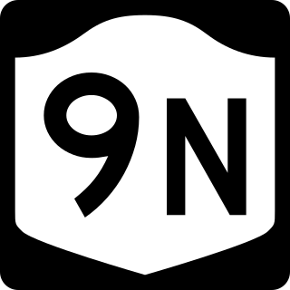
New York State Route 9N (NY 9N) is a north–south state highway in northeastern New York in the United States. It extends from an intersection with U.S. Route 9 (US 9), NY 29, and NY 50 in the city of Saratoga Springs to a junction with US 9 and NY 22 in the Clinton County hamlet of Keeseville. At 143.49 miles (230.92 km) in total length, NY 9N is the longest letter-suffixed route in the state. It is concurrent with its parent route for 1 mile (1.6 km) in the village of Lake George and for three blocks in the hamlet of Elizabethtown.
Schroon Lake is a hamlet and census-designated place (CDP) in the town of Schroon in Essex County, New York, United States. The population was 833 at the 2010 census, or just over half of the total population of the town of Schroon.
Warrensburg is a town in Warren County, New York, United States. It is centrally located in the county, west of Lake George. It is part of the Glens Falls metropolitan area. The town population was 3,959 at the 2020 census. While the county is named after General Joseph Warren, the town is named after James Warren, a prominent early settler. U.S. Route 9 passes through the town, which is immediately west of Interstate 87.
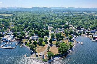
Westport is a hamlet and census-designated place (CDP) in the town of Westport in Essex County, New York, United States. The population of the CDP was 518 at the 2010 census, or 39.4% of the total population of the town of Westport.