Newcomb, New York

Last updated

Newcomb, New York
Hudson in Adirondacks.jpg
The Hudson River in Newcomb, a few miles south of its source
Motto: 
"Heart of the Park"
Essex County New York incorporated and unincorporated areas Newcomb highlighted.svg
Location in Essex County and the state of New York
Coordinates: 43°58′17″N74°9′39″W / 43.97139°N 74.16083°W / 43.97139; -74.16083
CountryUnited States
State New York
County Essex
Government
  Type Town Council
   Town Supervisor Robin DeLoria (R)
   Town Council
Members' List
Area
[1]
  Total233.17 sq mi (603.90 km2)
  Land226.19 sq mi (585.83 km2)
  Water6.98 sq mi (18.07 km2)
Elevation
1,946 ft (593 m)
Population
 (2010)
  Total436
  Estimate 
(2016) [2]
416
  Density1.84/sq mi (0.71/km2)
Time zone UTC−5 (Eastern (EST))
  Summer (DST) UTC−4 (EDT)
ZIP codes
12852, 12879
Area code 518
FIPS code 36-031-50144
GNIS feature ID0979261
Website newcombny.com

Newcomb is a town in Essex County, New York, United States. The population was 436 at the 2010 census. [3]

Contents

The town is on the western border of the county. It is 86 miles (138 km) by road southwest of Plattsburgh, 77 miles (124 km) southwest of Burlington, Vermont, 110 miles (180 km) northeast of Utica, 112 miles (180 km) north-northwest of Albany, and 146 miles (235 km) south-southwest of Montreal. [4] The town is inside the Adirondack Park and contains the Lake Harris Campground. The town is the largest by area in Essex County.

History

The town lies in an area historically claimed by both Iroquois and Algonquian tribes, and was on the frontier between colonial New York and New France.

The town was settled around 1816. Most of the early industry was devoted to harvesting lumber until the discovery of large iron ore deposits.

The town of Newcomb was established in 1828 from parts of the towns of Minerva and Moriah. It includes the hamlet of Newcomb, but does not contain an incorporated village.

By the end of the 19th century, the town was becoming famous as a sportsman's paradise.

Theodore Roosevelt was informed of the impending death of President William McKinley in September 1901 while hunting and hiking in the town.

Camp Santanoni and the Mount Adams Fire Observation Station, located atop Mount Adams, are listed on the National Register of Historic Places. [5]

Geography

Lake Harris in Newcomb Harris Lake.jpg
Lake Harris in Newcomb

According to the United States Census Bureau, the town has a total area of 233.2 square miles (603.9 km2), of which 226.3 square miles (586.0 km2) is land and 6.9 square miles (17.9 km2), or 2.96%, is water. [3] The Hudson River officially starts at Henderson Lake in the northeastern part of town and flows southward through the center of town.

The northern part of the western town line is the border of Hamilton County. The western section of the northern town boundary is the border of Franklin County.

New York State Route 28N, an east–west road, is a major highway in Newcomb.

Climate

Newcomb has a humid continental climate (Dfb) with warm summers coupled with cool nights and cold, snowy winters with seasonal snowfall averaging 104.9 inches (266 centimeters). [6]

Climate data for Newcomb, New York, 1991–2020 normals, extremes 1940–present
MonthJanFebMarAprMayJunJulAugSepOctNovDecYear
Record high °F (°C)60
(16)
62
(17)
78
(26)
88
(31)
91
(33)
95
(35)
94
(34)
94
(34)
91
(33)
85
(29)
74
(23)
62
(17)
95
(35)
Mean maximum °F (°C)45.9
(7.7)
47.7
(8.7)
57.4
(14.1)
73.0
(22.8)
82.9
(28.3)
86.1
(30.1)
86.3
(30.2)
84.5
(29.2)
82.0
(27.8)
74.1
(23.4)
61.6
(16.4)
48.2
(9.0)
88.5
(31.4)
Mean daily maximum °F (°C)25.6
(−3.6)
28.8
(−1.8)
37.3
(2.9)
50.2
(10.1)
64.3
(17.9)
72.4
(22.4)
76.6
(24.8)
74.5
(23.6)
67.4
(19.7)
54.4
(12.4)
41.4
(5.2)
30.6
(−0.8)
52.0
(11.1)
Daily mean °F (°C)14.7
(−9.6)
16.5
(−8.6)
25.3
(−3.7)
38.6
(3.7)
51.8
(11.0)
60.5
(15.8)
64.8
(18.2)
63.0
(17.2)
55.9
(13.3)
44.1
(6.7)
32.6
(0.3)
21.5
(−5.8)
40.8
(4.9)
Mean daily minimum °F (°C)3.7
(−15.7)
4.2
(−15.4)
13.2
(−10.4)
26.9
(−2.8)
39.2
(4.0)
48.7
(9.3)
53.0
(11.7)
51.6
(10.9)
44.3
(6.8)
33.7
(0.9)
23.8
(−4.6)
12.3
(−10.9)
29.6
(−1.3)
Mean minimum °F (°C)−19.6
(−28.7)
−16.8
(−27.1)
−10.9
(−23.8)
13.2
(−10.4)
27.2
(−2.7)
35.9
(2.2)
43.7
(6.5)
41.2
(5.1)
31.4
(−0.3)
22.3
(−5.4)
6.6
(−14.1)
−10.2
(−23.4)
−23.5
(−30.8)
Record low °F (°C)−36
(−38)
−40
(−40)
−31
(−35)
−3
(−19)
18
(−8)
25
(−4)
31
(−1)
29
(−2)
22
(−6)
10
(−12)
−19
(−28)
−31
(−35)
−40
(−40)
Average precipitation inches (mm)3.33
(85)
2.73
(69)
3.09
(78)
3.55
(90)
4.24
(108)
4.35
(110)
4.20
(107)
4.23
(107)
3.70
(94)
4.50
(114)
3.74
(95)
3.83
(97)
45.49
(1,154)
Average snowfall inches (cm)23.9
(61)
23.4
(59)
19.6
(50)
4.6
(12)
0.2
(0.51)
0.0
(0.0)
0.0
(0.0)
0.0
(0.0)
0.0
(0.0)
0.8
(2.0)
8.6
(22)
23.8
(60)
104.9
(266.51)
Average extreme snow depth inches (cm)17.9
(45)
23.3
(59)
23.4
(59)
11.5
(29)
02.
(5.1)
0.0
(0.0)
0.0
(0.0)
0.0
(0.0)
0.0
(0.0)
0.6
(1.5)
4.7
(12)
12.0
(30)
26.5
(67)
Average precipitation days (≥ 0.01 in)17.213.112.412.713.413.012.811.811.213.713.716.3161.3
Average snowy days (≥ 0.1 in)15.111.48.63.50.20.00.00.00.00.85.513.058.1
Source 1: NOAA [6]
Source 2: National Weather Service [7]

Demographics

Historical population
CensusPop.Note
1830 62
1840 7419.4%
1850 277274.3%
1860 157−43.3%
1870 17813.4%
1880 23733.1%
1890 28319.4%
1900 50779.2%
1910 5090.4%
1920 313−38.5%
1930 43739.6%
1940 4605.3%
1950 1,212163.5%
1960 1,187−2.1%
1970 957−19.4%
1980 681−28.8%
1990 544−20.1%
2000 481−11.6%
2010 436−9.4%
2016 (est.)416 [2] −4.6%
U.S. Decennial Census [8]

As of the census [9] of 2000, there were 481 people, 211 households, and 140 families residing in the town. The population density was 2.1 people per square mile (0.8/km2). There were 655 housing units at an average density of 2.9 per square mile (1.1/km2). The racial makeup of the town was 95.22% White, 0.62% Native American, 0.62% from other races, and 3.53% from two or more races. Hispanic or Latino of any race were 0.42% of the population.

There were 211 households, out of which 19.9% had children under the age of 18 living with them, 60.2% were married couples living together, 4.3% had a female householder with no husband present, and 33.2% were non-families. 30.3% of all households were made up of individuals, and 16.1% had someone living alone who was 65 years of age or older. The average household size was 2.26 and the average family size was 2.81.

In the town, the population was spread out, with 19.5% under the age of 18, 3.7% from 18 to 24, 18.9% from 25 to 44, 31.0% from 45 to 64, and 26.8% who were 65 years of age or older. The median age was 51 years. For every 100 females, there were 96.3 males. For every 100 females age 18 and over, there were 93.5 males.

The median income for a household in the town was $32,639, and the median income for a family was $41,875. Males had a median income of $35,750 versus $28,750 for females. The per capita income for the town was $17,043. About 5.8% of families and 9.1% of the population were below the poverty line, including 19.5% of those under age 18 and 3.5% of those age 65 or over.

Communities and locations in Newcomb

SUNY-ESF Newcomb Campus SIGN AT THE ENTRANCE TO THE STATE UNIVERSITY OF NEW YORK COLLEGE OF ENVIRONMENTAL SCIENCE AND FORESTRY IN THE... - NARA - 554693.jpg
SUNY-ESF Newcomb Campus

Related Research Articles

<span class="mw-page-title-main">Twin Lake, Michigan</span> Census-designated place in Michigan, United States

Twin Lake is an unincorporated community in Muskegon County of the U.S. state of Michigan. It is a census-designated place (CDP) for statistical purposes. Local government services are provided by Dalton Township. As of the 2020 census, the population of the CDP was 2,056. The surrounding area is the home of Blue Lake Fine Arts Camp, the YMCA's Camp Pinewood, and the Boy Scouts' Gerber Scout Reservation and Owasippe Scout Reservation.

<span class="mw-page-title-main">Machias, New York</span> Town in New York, United States

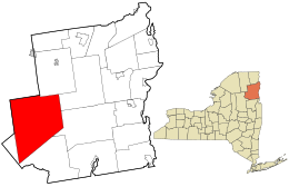
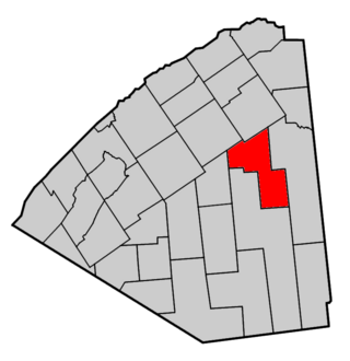
Machias is a town in Cattaraugus County, New York, United States. The population was 2,309 at the 2020 census. Machias is an interior town in the northeast quadrant of the county. It is northeast of the city of Salamanca.

<span class="mw-page-title-main">Black Brook, New York</span> Town in New York, United States

Black Brook is a town in Clinton County, New York, United States. The population was 1,497 at the 2010 census. It is named after a stream that flows through the town.

<span class="mw-page-title-main">Copake, New York</span> Town in New York, United States

Copake is a town in Columbia County, New York, United States. The population was 3,346 at the 2020 US census, down from 3,615 at the 2010 census. The town derives its name from a lake, which was known to the natives as Cook-pake, or Ack-kook-peek, meaning "Snake Pond".

<span class="mw-page-title-main">Gallatin, New York</span> Town in New York, United States

Gallatin is a town in Columbia County, New York, United States. The population at 2020 was 1,628, down from 1,668 at the 2010 census. Gallatin is on the southern border of Columbia County and located 100 miles (160 km) north of New York City.

<span class="mw-page-title-main">LaGrange, New York</span> Town in New York, United States

LaGrange is a town in Dutchess County, New York, United States. The population was 15,975 at the 2020 census. The town was named after the estate of the Marquis de Lafayette.

<span class="mw-page-title-main">Minerva, New York</span> Town in New York, United States

Minerva is a town in Essex County, New York, United States. The population was 773 at the 2020 census. The town is named after Minerva, the Roman goddess of wisdom. The town has a highly irregular polygonal shape. It is located in the southwestern corner of the county. By road, it is 40 miles (64 km) north-northwest of Queensbury, 85 miles (137 km) southwest of Burlington, Vermont, 88 miles (142 km) south of Plattsburgh, 93 miles (150 km) north of Albany, and 147 miles (237 km) south of Montreal, Quebec.

<span class="mw-page-title-main">North Hudson, New York</span> Town in New York, United States

North Hudson is a town in Essex County, New York, United States. The population was 240 at the 2010 census. The town derives its name by being near the northern end of the Hudson River.

<span class="mw-page-title-main">Franklin, Franklin County, New York</span> Town in New York, United States

Franklin is a town located in Franklin County, New York, United States. As of the 2010 census, the town had a population of 1,140.

<span class="mw-page-title-main">Santa Clara, New York</span> Town in New York, United States

Santa Clara is a town in Franklin County, New York, United States. The population was 345 at the 2010 census. The name was derived from the wife of an early town businessman, John Hurd.

<span class="mw-page-title-main">Long Lake, New York</span> Town in New York, United States

Long Lake is a town in Hamilton County, New York, United States. The population was 791 at the 2020 census.

<span class="mw-page-title-main">Springfield, New York</span> Town in New York, United States

Springfield is a town in Otsego County, New York, United States. The population was 1,358 at the 2010 census.

<span class="mw-page-title-main">Putnam Valley, New York</span> Town in New York, United States

Putnam Valley is a town in Putnam County, New York, United States. The population was 11,809 at the 2010 census. Its location is northeast of New York City, in the southwestern part of Putnam County. Putnam Valley calls itself the "Town of Lakes".

<span class="mw-page-title-main">Colton, New York</span> Town in New York, United States

Colton is a town in St. Lawrence County, New York, United States. The population was 1,451 at the 2010 census. The town, originally named "Matildaville", is named after early settler Jesse Colton Higley.

<span class="mw-page-title-main">Parishville, New York</span> Town in New York, United States

Parishville is a town in the east-central part of St. Lawrence County, east of Potsdam, in the state of New York, United States. The population was 2,153 at the 2010 census.

<span class="mw-page-title-main">Piercefield, New York</span> Town in New York, United States

Piercefield is a town in St. Lawrence County, New York, United States. The population was 310 at the 2010 census.

<span class="mw-page-title-main">Johnsburg, New York</span> Town in New York, United States

Johnsburg is a town in the northwestern corner of Warren County, New York, United States. It is part of the Glens Falls Metropolitan Statistical Area. The town population was 2,143 at the 2020 census. The town is named after John Thurman, an early settler and founder. Johnsburg is the largest town in Warren County by area.

<span class="mw-page-title-main">Thurman, New York</span> Town in New York, United States

Thurman is a town in the western part of Warren County, New York, United States. It is part of the Glens Falls Metropolitan Statistical Area. The town population was 1,199 at the 2000 census. The town is named after John Thurman, an early landowner. The town lies entirely inside the Adirondack Park.

<span class="mw-page-title-main">Dresden, Washington County, New York</span> Town in New York, United States

Dresden is a town in northern Washington County, New York, United States. It is part of the Glens Falls Metropolitan Statistical Area. The town population was 677 at the 2000 census.

<span class="mw-page-title-main">Brighton, Vermont</span> Town in Vermont, United States

Brighton is a town in Essex County, Vermont, United States. The population was 1,157 at the 2020 census. The town was named "Gilead" in its original grant in 1780. The town was sold to a group consisting primarily of soldiers commanded by Colonel Joseph Nightingale and subsequently named "Random". The town's name was finally changed by the legislature to "Brighton" in 1832. The Brighton village of Island Pond gets its name from the Abenaki word Menanbawk, which literally means island pond.

References

  1. "2016 U.S. Gazetteer Files". United States Census Bureau. Retrieved July 4, 2017.
  2. 1 2 "Population and Housing Unit Estimates" . Retrieved June 9, 2017.
  3. 1 2 "Geographic Identifiers: 2010 Demographic Profile Data (G001): Newcomb town, Essex County, New York". U.S. Census Bureau, American Factfinder. Retrieved March 4, 2016.[ dead link ]
  4. Google Maps
  5. "National Register Information System". National Register of Historic Places . National Park Service. March 13, 2009.
  6. 1 2 "U.S. Climate Normals Quick Access – Station: Newcomb, NY". National Oceanic and Atmospheric Administration. Retrieved October 12, 2023.
  7. "NOAA Online Weather Data – NWS Burlington". National Weather Service. Retrieved October 12, 2023.
  8. "Census of Population and Housing". Census.gov. Retrieved June 4, 2015.
  9. "U.S. Census website". United States Census Bureau . Retrieved January 31, 2008.

43°58′10″N74°09′53″W / 43.96944°N 74.16472°W / 43.96944; -74.16472