North Hudson, New York

Last updated

North Hudson, New York
Motto: 
"The Hub of the Adirondacks"
Essex County New York incorporated and unincorporated areas North Hudson highlighted.svg
Location in Essex County and the state of New York
Coordinates: 43°59′47″N73°43′17″W / 43.99639°N 73.72139°W / 43.99639; -73.72139
Country United States
State New York
County Essex
Government
  Type Town Council
   Town Supervisor Cassandra D'Agostino
   Town Council
Members' List
Area
[1]
  Total184.67 sq mi (478.29 km2)
  Land181.45 sq mi (469.96 km2)
  Water3.22 sq mi (8.33 km2)
Elevation
1,549 ft (472 m)
Population
 (2010)
  Total240
  Estimate 
(2016) [2]
236
  Density1.30/sq mi (0.50/km2)
Time zone UTC-5 (Eastern (EST))
  Summer (DST) UTC-4 (EDT)
ZIP code
12855
Area code 518
FIPS code 36-031-53077
GNIS feature ID0979290
Website northhudsonny.com

North Hudson is a town in Essex County, New York, United States. The population was 240 at the 2010 census. [3] The town derives its name by being near the northern end of the Hudson River.[ citation needed ]

Contents

The town is in the south-central part of the county and is south of Plattsburgh. North Hudson is within the Adirondack Park.

History

The region was first settled circa 1800. Early pioneers chose the southeastern part of the town.

The town was formed in 1848 from the town of Moriah. Early industry was based on tanning, owing to the presence of hemlock bark from the forests. Later, the trees were harvested for wood pulp.

By the end of the 19th century, the tourist trade began to predominate, especially at Underwood and Elk Lake. The theme park Frontier Town, a Wild West themed family tourist attraction, operated here from 1952 to 1998. The closure of Frontier Town had a severe negative impact on the town's economy. [4] In 2018, Frontier Town reopened as Adirondack campground and day-use area. [5] [6]

Geography

According to the United States Census Bureau, the town has a total area of 184.7 square miles (478.3 km2), of which 181.5 square miles (470.0 km2) is land and 3.2 square miles (8.3 km2), or 1.74%, is water. [3]

Two branches of the Schroon River, a south-flowing tributary of the Hudson River, arise in North Hudson.

The Adirondack Northway (Interstate 87) and U.S. 9 traverse the town as north-south highways. I-87 Exits 29 (North Hudson hamlet) and 30 (US-9) are within the town.

Climate

MonthJanFebMarAprMayJunJulAugSepOctNovDecYear
Mean daily maximum °F (°C)31.0
(−0.6)
34.0
(1.1)
43.0
(6.1)
56.0
(13.3)
70.0
(21.1)
77.0
(25.0)
83.0
(28.3)
81.0
(27.2)
74.0
(23.3)
59.0
(15.0)
47.0
(8.3)
35.0
(1.7)
57.5
(14.2)
Mean daily minimum °F (°C)10.0
(−12.2)
11.0
(−11.7)
19.0
(−7.2)
32.0
(0.0)
44.0
(6.7)
54.0
(12.2)
58.0
(14.4)
57.0
(13.9)
49.0
(9.4)
39.0
(3.9)
28.0
(−2.2)
18.0
(−7.8)
34.9
(1.6)
Average precipitation inches (mm)2.3
(58)
2.3
(58)
2.7
(69)
2.9
(74)
3.5
(89)
3.9
(99)
3.4
(86)
3.8
(97)
3.4
(86)
3.4
(86)
3.1
(79)
2.8
(71)
37.5
(952)
Average snowfall inches (cm)15.6
(40)
14.9
(38)
13.0
(33)
3.4
(8.6)
0.1
(0.25)
0.0
(0.0)
0.0
(0.0)
0.0
(0.0)
0.0
(0.0)
0.4
(1.0)
4.5
(11)
15.2
(39)
67.1
(170.85)
Average precipitation days7.06.07.08.09.010.09.08.07.08.07.07.093
Average snowy days6.05.04.01.00.00.00.00.00.00.01.06.023
Mean daily daylight hours 9.510.512.013.514.515.515.014.012.511.09.59.012.2
[ citation needed ]

Demographics

Historical population
CensusPop.Note
1850 561
1860 297−47.1%
1870 738148.5%
1880 693−6.1%
1890 656−5.3%
1900 544−17.1%
1910 434−20.2%
1920 397−8.5%
1930 235−40.8%
1940 2443.8%
1950 2585.7%
1960 220−14.7%
1970 212−3.6%
1980 179−15.6%
1990 26648.6%
2000 2660.0%
2010 240−9.8%
2016 (est.)236 [2] −1.7%
U.S. Decennial Census [7]

As of the census [8] of 2000, there were 266 people, 114 households, and 76 families residing in the town. The population density was 1.5 people per square mile (0.6/km2). There were 279 housing units, at an average density of 1.5 per square mile (0.6/km2). The racial makeup of the town was 94.74% White, 1.13% Native American, 0.38% Asian, and 3.76% from two or more races.

There were 114 households, of which 27.2% had children under the age of 18 living with them, 55.3% were married couples living together, 6.1% had a female householder with no husband present, and 32.5% were nonfamilies. 28.1% of all households were made up of individuals, and 11.4% had someone living alone who was 65 years of age or older. The average household size was 2.33 and the average family size was 2.88.

In the town, the population was spread out, with 24.4% under the age of 18, 7.1% from 18 to 24, 22.6% from 25 to 44, 28.6% from 45 to 64, and 17.3% who were 65 years of age or older. The median age was 41 years. For every 100 females, there were 101.5 males. For every 100 females age 18 and over, there were 95.1 males.

The median income for a household in the town was $28,977, and the median family income was $40,833. Males had a median income of $36,250 versus $20,833 for females. The per capita income for the town was $16,075. About 9.7% of families and 10.1% of the population were below the poverty line, including 6.0% of those under the age of eighteen and 10.5% of those 65 or over.

Communities and locations in North Hudson

Related Research Articles

<span class="mw-page-title-main">Essex County, New York</span> County in New York, United States

Essex County is a county in the U.S. state of New York. As of the 2020 census, the population was 37,381. Its county seat is the hamlet of Elizabethtown. Its name is from the English county of Essex. Essex is one of only 2 counties that are entirely within the Adirondack Park, the other being Hamilton County. The county is part of the North Country region of the state.

<span class="mw-page-title-main">AuSable, New York</span> Town in New York, United States

Au Sable, or Ausable, is a town in Clinton County, New York, United States. The population was 3,146 at the 2010 census. The name is from the Ausable River that flows through the town and means "of sand".

<span class="mw-page-title-main">Chesterfield, New York</span> Town in New York, United States

Chesterfield is a town in Essex County, New York, United States. The population was 2,445 at the 2010 census. The name possibly is from a location in New England.

<span class="mw-page-title-main">Elizabethtown, New York</span> Town in New York, United States

Elizabethtown is a town in Essex County, New York, United States. The population was 1,163 at the 2010 census. The county seat of Essex County is the hamlet of Elizabethtown, located in the northern part of the town. The name is derived from Elizabeth Gilliland, the wife of an early settler.

<span class="mw-page-title-main">Jay, New York</span> Town in New York, United States

Jay is a town in Essex County, New York, United States. The population was 2,506 at the 2010 census. The town is named after John Jay, governor of New York when the town was formed.

<span class="mw-page-title-main">Lewis, Essex County, New York</span> Town in Essex County, New York, US

Lewis is a town in Essex County, New York, United States. The population was 1,382 at the 2010 census. The town is named after Morgan Lewis, the governor of New York at the time the town was established.

<span class="mw-page-title-main">Minerva, New York</span> Town in New York, United States

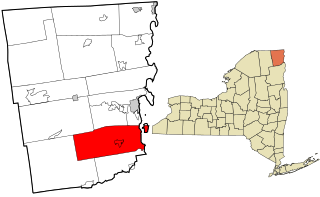
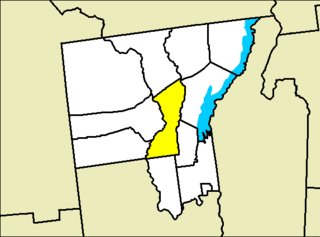
Minerva is a town in Essex County, New York, United States. The population was 773 at the 2020 census. The town is named after Minerva, the Roman goddess of wisdom. The town has a highly irregular polygonal shape. It is located in the southwestern corner of the county. By road, it is 40 miles (64 km) north-northwest of Queensbury, 85 miles (137 km) southwest of Burlington, Vermont, 88 miles (142 km) south of Plattsburgh, 93 miles (150 km) north of Albany, and 147 miles (237 km) south of Montreal, Quebec.

<span class="mw-page-title-main">Moriah, New York</span> Town in New York, United States

Moriah is a town in Essex County, New York, United States. Lying within the Adirondack Park, it is situated in the eastern part of the county, 47 miles (76 km) by road south-southwest of Burlington, Vermont, 55 miles (89 km) south of Plattsburgh, 115 miles (185 km) north of Albany, and 116 miles (187 km) south of Montreal, Quebec. The population was 4,798 at the 2010 census.

<span class="mw-page-title-main">Newcomb, New York</span> Town in New York, United States

Newcomb is a town in Essex County, New York, United States. The population was 436 at the 2010 census.

<span class="mw-page-title-main">Schroon, New York</span> Town in New York, United States

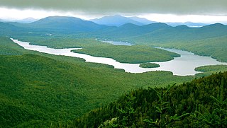
Schroon is a town in the Adirondack Park, in Essex County, New York, United States. The population was 1,880 at the 2020 census. The largest community in the town is the hamlet of Schroon Lake, located at the northern end of the lake of the same name.

<span class="mw-page-title-main">Halfmoon, New York</span> Town in New York, United States

Halfmoon is a town in Saratoga County, New York, United States. The population was 25,662 at the 2020 census. The town is apparently named for the shape of the lower elevation land north of the junction of the Hudson and Mohawk Rivers. It is also said to be named for Henry Hudson's ship, the Halve Maen.

<span class="mw-page-title-main">Moreau, New York</span> Town in New York, United States

Moreau is a town in Saratoga County, New York, United States. The population was 16,202 at the 2020 census. The town is located in the northeast part of the county, north of Saratoga Springs. Moreau is named after Jean Victor Moreau, a French general, who visited the area just before the town was formed. The town contains a village called South Glens Falls.

<span class="mw-page-title-main">Chester, Warren County, New York</span> Town in New York, United States

Chester is a town in Warren County, New York, United States. It is part of the Glens Falls metropolitan area. The population was 3,086 at the 2020 census. The town is made up by communities of Chestertown and Pottersville.

<span class="mw-page-title-main">Horicon, New York</span> Town in New York, United States

Horicon is a town in Warren County, New York, United States. It is part of the Glens Falls Metropolitan Statistical Area. Horicon's population was 1,389 at the 2010 census.

<span class="mw-page-title-main">Keeseville, New York</span> Hamlet and CDP in New York, United States

Keeseville is a hamlet in Clinton and Essex counties, New York, United States. The population was 1,815 at the 2010 census. The hamlet was named after the Keese family, early settlers from Vermont. It developed along the Ausable River, which provided water power for mills and industrial development.

<span class="mw-page-title-main">Peru, New York</span> Town in New York, United States

Peru is a town in Clinton County in the U.S. state of New York. The population was 6,772 at the 2020 census. The town was so named for its views of the Adirondack Mountains to the west and the farmlands throughout the town, resembling scenery found in the country of Peru in South America. Peru, New York, is in the southeastern part of Clinton County, south of Plattsburgh.

<span class="mw-page-title-main">Plattsburgh (town), New York</span> Town in New York, United States

Plattsburgh is a town in Clinton County, New York, United States. The population was 11,886 at the 2020 census. The town is named after Zephaniah Platt, an early land owner, and it surrounds the separate and more populous city of the same name. The town is in the eastern part of the county, in the North Country region of the state of New York. The region's airport, Plattsburgh International Airport, is located in the southern part of the town.

Schroon Lake is a hamlet and census-designated place (CDP) in the town of Schroon in Essex County, New York, United States. The population was 833 at the 2010 census, or just over half of the total population of the town of Schroon.

Warrensburg is a census-designated place (CDP) in Warren County, New York, United States. The population was 3,045 at the 2020 census. It is part of the Glens Falls Metropolitan Statistical Area.

<span class="mw-page-title-main">Warrensburg, New York</span> Town in New York, United States

Warrensburg is a town in Warren County, New York, United States. It is centrally located in the county, west of Lake George. It is part of the Glens Falls metropolitan area. The town population was 3,959 at the 2020 census. While the county is named after General Joseph Warren, the town is named after James Warren, a prominent early settler. U.S. Route 9 passes through the town, which is immediately west of Interstate 87.

References

  1. "2016 U.S. Gazetteer Files". United States Census Bureau. Retrieved July 4, 2017.
  2. 1 2 "Population and Housing Unit Estimates" . Retrieved June 9, 2017.
  3. 1 2 "Geographic Identifiers: 2010 Demographic Profile Data (G001): North Hudson town, Essex County, New York". U.S. Census Bureau, American Factfinder. Retrieved March 4, 2016.[ dead link ]
  4. "How Closure of 'Frontier Town' Theme Park Devastated a Tiny New York Town". Governing. August 4, 2016.
  5. "It's official: Frontier Town reopens as Adirondack "hub" destination". North Country Public Radio . October 5, 2018.
  6. ""Frontier Town" officially reopens in Essex County, adding I-87 amenity". North Country Public Radio . June 27, 2019.
  7. "Census of Population and Housing". Census.gov. Retrieved June 4, 2015.
  8. "U.S. Census website". United States Census Bureau . Retrieved January 31, 2008.

43°57′09″N73°43′42″W / 43.95250°N 73.72833°W / 43.95250; -73.72833