Related Research Articles

Faribault County is a county in the U.S. state of Minnesota. As of the 2020 census, the population was 13,921. Its county seat is Blue Earth.

Sac County is a county located in the U.S. state of Iowa. As of the 2020 census, the population was 9,814. The county seat is Sac City. Both were named for the Sauk people, a local American Indian tribe.

Ida County is a county located in the U.S. state of Iowa. As of the 2020 census the population was 7,005, making it the state's eighth-least populous county. The county seat is Ida Grove. The county was authorized by the Iowa Legislature in January 1851 as a packet of projected counties in unorganized territory of western Iowa. It was named after Ida Smith, the first child of European immigrants to be born in this region.

Fremont County is a county located in the U.S. state of Iowa. As of the 2020 census the population was 6,605, making it the state's seventh-least populous county. The county seat is Sidney. The county was formed in 1847 and named for the military officer John C. Frémont.

Crawford County is a county located in the U.S. state of Iowa. As of the 2020 census, the population was 16,525. Its county seat is Denison. The county was named for William Harris Crawford, U.S. senator from Georgia and United States Secretary of the Treasury.

Early is a city in Sac County, Iowa, United States. The population was 587 at the 2020 census.
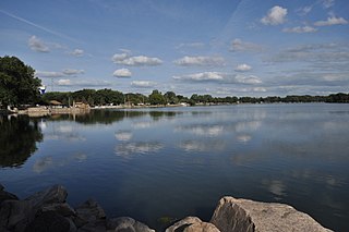
Lake View is a city in Sac County, Iowa, United States. The population was 1,113 in the 2020 census, a decline from the 1,278 population in 2000.

Nemaha is a city in Sac County, Iowa, United States. The population was 66 at the time of the 2020 census.

Sac City is a city in and the county seat of Sac County, Iowa, United States, located just southwest of the eastern intersection of U.S. Routes 20 and 71 in the rolling hills along the valley of the North Raccoon River. The city is one of 45 designated Main Street Iowa communities through the Main Street Iowa development program. The population was 2,063 in the 2020 census, a decline from the 2,368 population in 2000.

Schaller is a city in Sac County, Iowa, United States. The population was 729 at the time of the 2020 census.
Cedar Township is a township in Sac County, Iowa, USA. Part of Lytton, Iowa is within Cedar Township.
Boyer Valley Township is a township in Sac County, Iowa, United States. Early is contained within Boyer Valley Township.
Clinton Township is a township in Sac County, Iowa, USA.
Delaware Township is a township in Sac County, Iowa, United States. Nemaha is contained within Delaware Township.
Douglas Township is a township in Sac County, Iowa, USA.
Levey Township is a township in Sac County, Iowa, USA. Part of Wall Lake is within Levey Township.
Floyd Township is a township in Sioux County, in northwestern Iowa, USA. The 2020 Decennial Census reported that it had a population of 1,110 persons in 446 households.
Cummins Township is a township in Pocahontas County, Iowa, United States. Havelock is contained within Cummins Township.
Lincoln Township is a township in O'Brien County, Iowa, United States.
Seneca Township is a minor civil division in Kossuth County, Iowa, United States.
References
- 1 2 "Plat book of Sac County, Iowa, 1930 :: Hixson Plat Map Atlases of Iowa". digital.lib.uiowa.edu. Retrieved August 16, 2019.
- ↑ "Schaller, IA Profile: Facts & Data". iowa.hometownlocator.com. Retrieved August 16, 2019.
- 1 2 Hart, William (1914). History of Sac County, Iowa. Indianapolis, Indiana: B. F. Bowen & Co. p. 210.
- ↑ "Towns and Townships". iagenweb.org. Retrieved August 16, 2019.
- ↑ Commission., United States Entomological (1878–1990). Report of the United States Entomological commission. Govt. Print. Off. OCLC 297653972.
- ↑ Mott, David C. (1931). "Abandoned Towns, Villages and Post Offices of Iowa". The Annals of Iowa. 18 (2): 117–148. doi: 10.17077/0003-4827.5505 . ISSN 0003-4827.
- 1 2 Bureau, U. S. Census. "U.S. Census website". United States Census Bureau . Retrieved August 16, 2019.
- ↑ "GNIS Search Results". geonames.usgs.gov. Retrieved August 16, 2019.
- ↑ "Facility Summary". programs.iowadnr.gov. Retrieved September 30, 2021.
- 1 2 "Eureka township, Sac County, Iowa". data.census.gov. Retrieved February 4, 2022.
- ↑ "DP05 ACS DEMOGRAPHIC AND HOUSING ESTIMATES". data.census.gov. Retrieved February 4, 2022.
- ↑ "GreatSchools: See what school district you are in or moving to using our interactive map". See What School District You Are In. Retrieved September 1, 2019.
- ↑ "COUNTY OF SAC – Supervisor Districts" Sac County, Iowa
- ↑ "Iowa Legislature - Find Your Legislator". www.legis.iowa.gov. Retrieved July 24, 2023.
- ↑ "2020 Iowa U.S. House – District 4 Election Results" Las Cruces Sun-News, January 11, 2021.
Municipalities and communities of Sac County, Iowa, United States | ||
|---|---|---|
| Cities |  | |
| Townships | ||
| Unincorporated community | ||
| Ghost town | ||
| Footnotes | ‡This populated place also has portions in an adjacent county or counties | |