Nemaha, Iowa

Last updated
Nemaha, Iowa
Motto: 
A Mighty Small Town
Sac County Iowa Incorporated and Unincorporated areas Nemaha Highlighted.svg
Location of Nemaha, Iowa
USA Iowa relief location map.svg
Red pog.svg
Nemaha
Location within Iowa
Usa edcp relief location map.png
Red pog.svg
Nemaha
Location within the United States
Coordinates: 42°30′54″N95°5′22″W / 42.51500°N 95.08944°W / 42.51500; -95.08944 Coordinates: 42°30′54″N95°5′22″W / 42.51500°N 95.08944°W / 42.51500; -95.08944
Country Flag of the United States.svg  United States
State Flag of Iowa.svg  Iowa
County Sac
Township Delaware
Area
[1]
  Total0.08 sq mi (0.22 km2)
  Land0.08 sq mi (0.22 km2)
  Water0.00 sq mi (0.00 km2)
Elevation
1,322 ft (403 m)
Population
 (2020)
  Total66
  Density785.71/sq mi (302.25/km2)
Time zone UTC-6 (Central (CST))
  Summer (DST) UTC-5 (CDT)
ZIP code
50567
Area code 712
FIPS code 19-55515
GNIS feature ID0459456

Nemaha is a city in Sac County, Iowa, United States. The population was 66 at the time of the 2020 census. [2]

Contents

Geography

Nemaha is located at 42°30′54″N95°5′22″W / 42.51500°N 95.08944°W / 42.51500; -95.08944 (42.514999, -95.089332). [3]

According to the United States Census Bureau, the city has a total area of 0.07 square miles (0.18 km2), all land. [4]

Demographics

Historical populations
YearPop.±%
1920 166    
1930 146−12.0%
1940 169+15.8%
1950 184+8.9%
1960 151−17.9%
1970 117−22.5%
1980 120+2.6%
1990 112−6.7%
2000 102−8.9%
2010 85−16.7%
2020 66−22.4%
Source: "U.S. Census website". United States Census Bureau . Retrieved 2020-03-29. and Iowa Data Center
Source:
U.S. Decennial Census [5] [2]

2010 census

As of the census [6] of 2010, there were 85 people, 33 households, and 23 families living in the city. The population density was 1,214.3 inhabitants per square mile (468.8/km2). There were 36 housing units at an average density of 514.3 per square mile (198.6/km2). The racial makeup of the city was 88.2% White, 3.5% African American, 1.2% Asian, and 7.1% from other races. Hispanic or Latino of any race were 12.9% of the population.

There were 33 households, of which 30.3% had children under the age of 18 living with them, 54.5% were married couples living together, 9.1% had a female householder with no husband present, 6.1% had a male householder with no wife present, and 30.3% were non-families. 24.2% of all households were made up of individuals, and 6% had someone living alone who was 65 years of age or older. The average household size was 2.58 and the average family size was 3.13.

The median age in the city was 39.5 years. 29.4% of residents were under the age of 18; 5.8% were between the ages of 18 and 24; 24.7% were from 25 to 44; 28.3% were from 45 to 64; and 11.8% were 65 years of age or older. The gender makeup of the city was 56.5% male and 43.5% female.

2000 census

As of the census [7] of 2000, there were 102 people, 42 households, and 25 families living in the city. The population density was 637.4 inhabitants per square mile (246.1/km2). There were 44 housing units at an average density of 275.0 per square mile (106.2/km2). The racial makeup of the city was 97.06% White, 0.98% Native American, and 1.96% from two or more races.

There were 42 households, out of which 35.7% had children under the age of 18 living with them, 54.8% were married couples living together, 4.8% had a female householder with no husband present, and 38.1% were non-families. 28.6% of all households were made up of individuals, and 9.5% had someone living alone who was 65 years of age or older. The average household size was 2.43 and the average family size was 3.08.

In the city, the population was spread out, with 26.5% under the age of 18, 7.8% from 18 to 24, 27.5% from 25 to 44, 24.5% from 45 to 64, and 13.7% who were 65 years of age or older. The median age was 38 years. For every 100 females, there were 131.8 males. For every 100 females age 18 and over, there were 120.6 males.

The median income for a household in the city was $27,708, and the median income for a family was $31,250. Males had a median income of $21,250 versus $28,125 for females. The per capita income for the city was $11,997. There were 8.3% of families and 9.5% of the population living below the poverty line, including no under eighteens and none of those over 64.

Education

Nemaha became now part of the Ridge View School District as of 2010, which formed when the Galva-Holstein and Schaller-Crestland school districts merged. Previously, it was a part of the Schaller-Crestland Community School District. [8] The district formed on July 1, 1993, by the merger of the Schaller Community School District and the Crestland Community School District. [9]

Before the merger with Crestland in 1958, Nemaha was an independent school district. They were known as the Blue Jays.

Related Research Articles

<span class="mw-page-title-main">Sac County, Iowa</span> County in Iowa, United States

Sac County is a county located in the U.S. state of Iowa. As of the 2020 census, the population was 9,814. The county seat is Sac City. Both were named for the Sauk people, a local American Indian tribe.

<span class="mw-page-title-main">Rembrandt, Iowa</span> City in Iowa, United States

Rembrandt is a city in Buena Vista County, Iowa, United States. The population was 209 at the time of the 2020 census.

<span class="mw-page-title-main">Charter Oak, Iowa</span> City in Iowa, United States

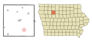
Charter Oak is a city in Crawford County, Iowa, United States, along the East Soldier River. The population was 535 at the 2020 census.

<span class="mw-page-title-main">Luxemburg, Iowa</span> City in Iowa, United States

Luxemburg is a city in Dubuque County, Iowa, United States. It is part of the Dubuque, Iowa Metropolitan Statistical Area. The population was 245 at the time of the 2020 census, down from 246 in 2000. The White Pine Hollow State Forest is located four miles to the northwest of Luxemburg.

<span class="mw-page-title-main">Williamson, Iowa</span> City in Iowa, United States

Williamson is a city in Lucas County, Iowa, United States. The population was 120 at the time of the 2020 census.

<span class="mw-page-title-main">Palmer, Iowa</span> City in Iowa, United States

Palmer is a city in Pocahontas County, Iowa, United States. The population was 138 at the time of the 2020 census.

<span class="mw-page-title-main">Early, Iowa</span> City in Iowa, United States

Early is a city in Sac County, Iowa, United States. The population was 587 at the 2020 census.

<span class="mw-page-title-main">Schaller, Iowa</span> City in Iowa, United States

Schaller is a city in Sac County, Iowa, United States. The population was 729 at the time of the 2020 census.

<span class="mw-page-title-main">Barnum, Iowa</span> City in Iowa, United States

Barnum is a city in Webster County, Iowa, United States, just off U.S. Route 20. The population was 175 at the 2020 census.

<span class="mw-page-title-main">Bronson, Iowa</span> City in Iowa, United States

Bronson is a city in Woodbury County, Iowa, United States. It is part of the Sioux City metropolitan area. The population was 294 at the 2020 census.

<span class="mw-page-title-main">Bern, Kansas</span> City in Nemaha County, Kansas

Bern is a city in Nemaha County, Kansas, United States. As of the 2020 census, the population of the city was 161.

<span class="mw-page-title-main">Corning, Kansas</span> City in Nemaha County, Kansas

Corning is a city in Nemaha County, Kansas, United States. As of the 2020 census, the population of the city was 212.

<span class="mw-page-title-main">Goff, Kansas</span> City in Nemaha County, Kansas

Goff is a city in Nemaha County, Kansas, United States. As of the 2020 census, the population of the city was 106.

<span class="mw-page-title-main">Seneca, Kansas</span> City in Nemaha County, Kansas

Seneca is a city in and the county seat of Nemaha County, Kansas, United States. As of the 2020 census, the population of the city was 2,139.

<span class="mw-page-title-main">Nemaha, Nebraska</span> Village in Nebraska, United States

Nemaha is a village in Nemaha County, Nebraska, United States. The population was 149 at the 2010 census.

<span class="mw-page-title-main">Rendville, Ohio</span> Village in Ohio, United States

Rendville is a village in Perry County, Ohio, United States. The population was 34 at the 2010 census, making it the smallest incorporated community in Ohio.

<span class="mw-page-title-main">El Indio, Texas</span> CDP in Texas, United States

El Indio is a census-designated place (CDP) in Maverick County, Texas, United States. The population was 263 at the 2000 census.

Arrowhead Springs is a census-designated place (CDP) in Sweetwater County, Wyoming, United States. The population was 63 at the 2010 census.

<span class="mw-page-title-main">Sabetha, Kansas</span> City in Brown and Nemaha Counties of Kansas

Sabetha is a city in Brown and Nemaha counties in the U.S. state of Kansas. As of the 2020 census, the population of the city was 2,545.

Madison is a village in Madison County, New York, United States. The population was 305 at the 2010 census. The village and its town are named after President James Madison.

References

  1. "2020 U.S. Gazetteer Files". United States Census Bureau. Retrieved March 16, 2022.
  2. 1 2 "2020 Census State Redistricting Data". census.gov. United states Census Bureau. Retrieved 12 August 2021.
  3. "US Gazetteer files: 2010, 2000, and 1990". United States Census Bureau. 2011-02-12. Retrieved 2011-04-23.
  4. "US Gazetteer files 2010". United States Census Bureau. Archived from the original on 2012-01-25. Retrieved 2012-05-11.
  5. "Census of Population and Housing". Census.gov. Retrieved June 4, 2015.
  6. "U.S. Census website". United States Census Bureau . Retrieved 2012-05-11.
  7. "U.S. Census website". United States Census Bureau . Retrieved 2008-01-31.
  8. "Schaller-Crestland." Iowa Department of Education. Retrieved on November 3, 2018.
  9. "REORGANIZATION & DISSOLUTION ACTIONS SINCE 1965-66." Iowa Department of Education. Retrieved on November 3, 2018.