Schaller, Iowa | |
---|---|
Coordinates: 42°29′50″N95°17′39″W / 42.49722°N 95.29417°W Coordinates: 42°29′50″N95°17′39″W / 42.49722°N 95.29417°W | |
Country | United States |
State | Iowa |
County | Sac |
Township | Eureka |
Area | |
• Total | 1.26 sq mi (3.26 km2) |
• Land | 1.26 sq mi (3.26 km2) |
• Water | 0.00 sq mi (0.00 km2) |
Elevation | 1,411 ft (430 m) |
Population (2020) | |
• Total | 729 |
• Density | 579.03/sq mi (223.59/km2) |
Time zone | UTC-6 (Central (CST)) |
• Summer (DST) | UTC-5 (CDT) |
ZIP code | 51053 |
Area code | 712 |
FIPS code | 19-71085 |
GNIS feature ID | 0465956 |
Schaller is a city in Sac County, Iowa, United States. The population was 729 at the time of the 2020 census. [2]
The city of Schaller, named after Phillip Schaller, [3] was incorporated in 1882. The city had been founded in August 1879 as a station for the railroad under construction. The economy, then as now, was based on commercial support for surrounding farms. Settlers came mostly from Germany, England, Canada, New York, and eastern Iowa. Throughout the middle part of the twentieth century a major industry consisted of the packers of Bango and Jolly Time popcorn. The presence and size of these two companies helped Schaller become "The Popcorn Capital of the world." Popcorn is still a major area industry, but the companies moved on to other locations in the 1980s. The railroad ceased operations and pulled up tracks in the 1970s. Transportation connections are by U.S. Route 20 and Iowa Highway 110. Corn (seed and feed), soybeans, and feeder cattle are the major products of the area.
Schaller is located at 42°29′50″N95°17′39″W / 42.49722°N 95.29417°W (42.497325, -95.294219). [4]
According to the United States Census Bureau, the city has a total area of 1.26 square miles (3.26 km2), all land. [5]
Year | Pop. | ±% |
---|---|---|
1890 | 333 | — |
1900 | 661 | +98.5% |
1910 | 646 | −2.3% |
1920 | 731 | +13.2% |
1930 | 724 | −1.0% |
1940 | 758 | +4.7% |
1950 | 841 | +10.9% |
1960 | 896 | +6.5% |
1970 | 835 | −6.8% |
1980 | 832 | −0.4% |
1990 | 768 | −7.7% |
2000 | 779 | +1.4% |
2010 | 772 | −0.9% |
2020 | 729 | −5.6% |
Source: "U.S. Census website". United States Census Bureau . Retrieved 2020-03-28. and Iowa Data Center Source: |
As of the census [7] of 2010, there were 772 people, 318 households, and 208 families living in the city. The population density was 612.7 inhabitants per square mile (236.6/km2). There were 341 housing units at an average density of 270.6 per square mile (104.5/km2). The racial makeup of the city was 93.5% White, 0.1% African American, 0.1% Native American, 0.3% Asian, 0.1% Pacific Islander, 3.0% from other races, and 2.8% from two or more races. Hispanic or Latino of any race were 9.6% of the population.
There were 318 households, of which 31.4% had children under the age of 18 living with them, 51.3% were married couples living together, 9.1% had a female householder with no husband present, 5.0% had a male householder with no wife present, and 34.6% were non-families. 29.6% of all households were made up of individuals, and 12% had someone living alone who was 65 years of age or older. The average household size was 2.43 and the average family size was 3.04.
The median age in the city was 38.8 years. 27.2% of residents were under the age of 18; 7.1% were between the ages of 18 and 24; 24% were from 25 to 44; 24.8% were from 45 to 64; and 16.8% were 65 years of age or older. The gender makeup of the city was 49.2% male and 50.8% female.
As of the census [8] of 2000, there were 779 people, 321 households, and 216 families living in the city. The population density was 619.4 inhabitants per square mile (239.2/km2). There were 347 housing units at an average density of 275.9 per square mile (106.5/km2). The racial makeup of the city was 97.82% White, 0.13% African American, 0.26% Native American, 0.26% Asian, 0.13% Pacific Islander, 0.64% from other races, and 0.77% from two or more races. Hispanic or Latino of any race were 3.08% of the population.
There were 321 households, out of which 30.2% had children under the age of 18 living with them, 54.8% were married couples living together, 9.3% had a female householder with no husband present, and 32.4% were non-families. 28.7% of all households were made up of individuals, and 14.0% had someone living alone who was 65 years of age or older. The average household size was 2.43 and the average family size was 2.97.
Age spread: 27.1% under the age of 18, 9.1% from 18 to 24, 23.6% from 25 to 44, 20.4% from 45 to 64, and 19.8% who were 65 years of age or older. The median age was 38 years. For every 100 females, there were 100.3 males. For every 100 females age 18 and over, there were 93.9 males.
The median income for a household in the city was $33,365, and the median income for a family was $40,268. Males had a median income of $26,964 versus $17,875 for females. The per capita income for the city was $15,520. About 2.6% of families and 5.0% of the population were below the poverty line, including 3.2% of those under age 18 and 5.1% of those age 65 or over.
It is a part of the Schaller-Crestland Community School District. [9] The district formed on July 1, 1993, by the merger of the Schaller Community School District and the Crestland Community School District. [10]
Sac County is a county located in the U.S. state of Iowa. As of the 2020 census, the population was 9,814. The county seat is Sac City. Both were named for the Sauk people, a local American Indian tribe.
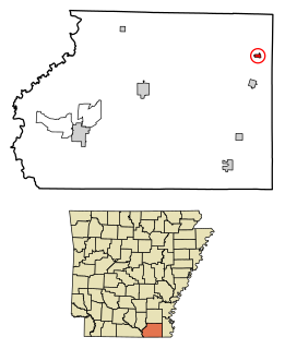
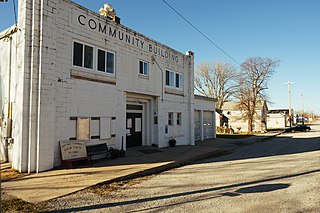
Montrose is a city in Ashley County, Arkansas, United States. The population was 354 at the 2010 census. Montrose is located where U.S. Route 165 intersects with U.S. Route 82.
Udell is a city in Appanoose County, Iowa, United States. The population was 28 at the time of the 2020 census.
Osterdock is a city located in Clayton County, Iowa, United States. As of the 2020 census, the city had a total population of 43, down from 50 in 2000.
Floris is a city in Davis County, Iowa, United States. The population was 116 at the time of the 2020 census.
Hamburg is a city in Fremont County, Iowa, United States, that is the most southwestern city in Iowa, hugging the borders of Missouri to the south and Nebraska to the west. It is situated between the Nishnabotna and Missouri rivers. The population was 890 at the time of the 2020 census. It derives its name from the German city of Hamburg.
Logan is a city and county seat of Harrison County, Iowa, United States, along the Boyer River. The population was 1,397 at the time of the 2020 census.
St. Donatus is a city in Jackson County, Iowa, United States. The population was 120 at the time of the 2020 census. St. Donatus is known for its status as a Luxembourger village, with historic architecture and views along U.S. Route 52. It is the home of a historic Catholic church, which is dedicated to Saint Donatus of Muenstereifel, the town's namesake. It was formerly named Tetes des Morts, which is the name of a creek that flows through the village.
Hills is a city in Johnson County, Iowa, United States. It is part of the Iowa City, Iowa Metropolitan Statistical Area. The population was 863 at the time of the 2020 census. It is part of the Iowa City Community School District.
Hastings is a city in Mills County, Iowa, United States. The population was 152 at the time of the 2020 census.
Hinton is a city in Plymouth County, Iowa, United States. The population was 935 at the time of the 2020 census.
Palmer is a city in Pocahontas County, Iowa, United States. The population was 138 at the time of the 2020 census.
McClelland is a city in Pottawattamie County, Iowa, United States. The city was founded in 1903 after the Great Western Railroad was extended to include Council Bluffs, IA. The population was 146 at the time of the 2020 census.
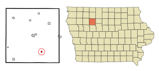
Early is a city in Sac County, Iowa, United States. The population was 587 at the 2020 census.
Nemaha is a city in Sac County, Iowa, United States. The population was 66 at the time of the 2020 census.
Sac City is a city in and the county seat of Sac County, Iowa, United States, located just southwest of the eastern intersection of U.S. Routes 20 and 71 in the rolling hills along the valley of the North Raccoon River. The city is one of 45 designated Main Street Iowa communities through the Main Street Iowa development program. The population was 2,063 in the 2020 census, a decline from the 2,368 population in 2000.
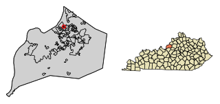
Glenview Hills is a home rule-class city in Jefferson County, Kentucky, United States. The population was 319 at the 2010 census.
Goose Creek is a home rule-class city in Jefferson County, Kentucky, United States. The population was 294 at the 2010 census.
Velda City is a city in St. Louis County, Missouri, United States. The population was 1,420 at the 2010 census.
South Franklin Township is a township in Washington County, Pennsylvania, United States. The population was 2,864 at the 2020 census.