Fenwood, Wisconsin

Last updated

Fenwood, Wisconsin
Marathon County Wisconsin Incorporated and Unincorporated areas Fenwood Highlighted.svg
Location of Fenwood in Marathon County, Wisconsin.
Coordinates: 44°51′56″N90°0′50″W / 44.86556°N 90.01389°W / 44.86556; -90.01389
Country Flag of the United States.svg  United States
State Flag of Wisconsin.svg  Wisconsin
County Marathon
Area
[1]
  Total0.98 sq mi (2.55 km2)
  Land0.98 sq mi (2.55 km2)
  Water0.00 sq mi (0.00 km2)
Elevation
[2]
1,296 ft (395 m)
Population
 (2010) [3]
  Total152
  Estimate 
(2019) [4]
155
  Density157.36/sq mi (60.78/km2)
Time zone UTC-6 (Central (CST))
  Summer (DST) UTC-5 (CDT)
Area code(s) 715 & 534
FIPS code 55-25650 [5]
GNIS feature ID1564913 [2]

Fenwood is a village in Marathon County, Wisconsin, United States. It is part of the Wausau, Wisconsin Metropolitan Statistical Area. The population was 152 at the 2010 census. [6]

Contents

History

Fenwood was platted by the railroad in 1891. [7] It was named from woods near the townsite at a fen, or marshy area. [7] A post office was established at Fenwood in 1892, and remained in operation until it was discontinued in 1984. [8]

The village of Fenwood, Marathon Co., Wisconsin was platted by Alfred L. Carey, the attorney for the Milwaukee, Lake Shore & Western Railroad, November 18, 1891, about the time when that railroad struck the place; it was incorporated as a village from part of the town of Wien, April 16, 1904, and its first representative in the county board of Marathon county was W. A. Somers. At the time the railroad struck the place, C. S. Curtis of Wausau erected a large saw mill, which was in operation until 1910, when it ceased sawing. At that time there was a large profitable cheese factory in the village, owned and supplied by farmers in the towns of Wien and Cleveland. John Brinkmann and Emil Szebsdat, under firm name of Brinkmann & Szeljsdat owned a general store, and George Wetterau kept the tavern or hotel in the village. Emil Szebsdat was also the village postmaster.

There was a nice state-graded frame schoolhouse with two “departments”: principal, Vallborg Hermanson, and assistant principal, Miss Gertrude Kurtzweil - an average attendance of forty-five pupils in both departments. There were two German Evangelical Lutheran congregations, holding their services in the schoolhouse and attended by the resident ministers of the town of Wien. https://wiclarkcountyhistory.org/neighbors/marathon/history/1913FenwoodHistory.htm

In 1911, the R. Connor Company of Marshfield, with its Marathon County mill located at Stratford, set to work clear- ing two sections of land four miles southeast of the village. This project, no doubt, had much to do in checking the out- ward flow of workmen and gave fresh energy to the entire community. A spur track extending from the mainline to Connor's woods provided an easy and rapid means of trans- porting logs from camp to the mill. The cut of 1913 climaxed the Connor harvest at this location and that season, two million feet of logs were decked at one time at their rollway. For several years more timbers were hauled into Fenwood from a 500-acre tract. This work was contracted by John Wetterau and was finished in 1928. These intermittent and spasmodic shipments marked the ex- piration of the industry which had given birth to the village. At one time the Chrouser Saw and Tie Mill was also in operation in Fenwood. This mill was operated by George Chrouser from 1908 until the late 1920s. The Fenwood mill was a branch of the Chrouser mill in Stratford. It consisted mainly in making ties for the railroad and custom sawing for area people. In the early 1900s, Fenwood was a booming lumber town. Proof of Fenwood's past prominence as a lumbering center is mutely evidenced today by unused and unusable logging roads. These keep an endless vigil against a time, never to come, when again one can hear the droning music of a saw punctuated by staccato notes as steel meets steel, in the rhythmic swings of lumberjacks, the dying symphony of the north woods. (This history of Fenwood was compiled by Lillian Bau- man using many histories and newspaper articles from area newspapers.) Early Fenwood. Photograph on loan from Delbert Wetterau. https://digicoll.library.wisc.edu/cgi-bin/WI/WI-idx?type=turn&id=WI.Fenwood&entity=WI.Fenwood.p0012&isize=text

Geography

Fenwood is located at 44°51′56″N90°0′50″W / 44.86556°N 90.01389°W / 44.86556; -90.01389 (44.865483, -90.013757). [9]

According to the United States Census Bureau, the village has a total area of 0.99 square miles (2.56 km2), all of it land. [10]

Demographics

Historical population
CensusPop.Note
1910 220
1920 178−19.1%
1930 136−23.6%
1940 15614.7%
1950 139−10.9%
1960 1475.8%
1970 1470.0%
1980 16512.2%
1990 21429.7%
2000 174−18.7%
2010 152−12.6%
2019 (est.)155 [4] 2.0%
U.S. Decennial Census [11]

2010 census

As of the census [3] of 2010, there were 152 people, 64 households, and 43 families living in the village. The population density was 153.5 inhabitants per square mile (59.3/km2). There were 67 housing units at an average density of 67.7 per square mile (26.1/km2). The racial makeup of the village was 97.4% White, 0.7% from other races, and 2.0% from two or more races. Hispanic or Latino of any race were 2.6% of the population.

There were 64 households, of which 31.3% had children under the age of 18 living with them, 54.7% were married couples living together, 4.7% had a female householder with no husband present, 7.8% had a male householder with no wife present, and 32.8% were non-families. 26.6% of all households were made up of individuals, and 9.4% had someone living alone who was 65 years of age or older. The average household size was 2.38 and the average family size was 2.84.

The median age in the village was 41 years. 19.7% of residents were under the age of 18; 8.6% were between the ages of 18 and 24; 25% were from 25 to 44; 38.1% were from 45 to 64; and 8.6% were 65 years of age or older. The gender makeup of the village was 52.6% male and 47.4% female.

2000 census

As of the census [5] of 2000, there were 174 people, 61 households, and 46 families living in the village. The population density was 176.7 people per square mile (68.6/km2). There were 63 housing units at an average density of 64.0 per square mile (24.8/km2). The racial makeup of the village was 100.00% White.

There were 61 households, out of which 39.3% had children under the age of 18 living with them, 67.2% were married couples living together, 4.9% had a female householder with no husband present, and 23.0% were non-families. 19.7% of all households were made up of individuals, and 14.8% had someone living alone who was 65 years of age or older. The average household size was 2.85 and the average family size was 3.32.

In the village, the population was spread out, with 25.3% under the age of 18, 17.8% from 18 to 24, 25.9% from 25 to 44, 14.9% from 45 to 64, and 16.1% who were 65 years of age or older. The median age was 32 years. For every 100 females, there were 104.7 males. For every 100 females age 18 and over, there were 106.3 males.

The median income for a household in the village was $44,000, and the median income for a family was $48,750. Males had a median income of $32,500 versus $17,679 for females. The per capita income for the village was $15,920. None of the population or families were below the poverty line.

Related Research Articles

<span class="mw-page-title-main">Spring Lake, Michigan</span> Village in Michigan, United States

Spring Lake is a village in Ottawa County in the U.S. state of Michigan. The population was 2,497 at the 2020 census. The village is located within Spring Lake Township; the two share a ZIP code.

<span class="mw-page-title-main">Malcolm, Nebraska</span> Village in Nebraska, United States

Malcolm is a village in Lancaster County, Nebraska, United States. It is part of the Lincoln, Nebraska Metropolitan Statistical Area. The population was 457 at the 2020 census.

<span class="mw-page-title-main">Fall Creek, Wisconsin</span> Village in Wisconsin, United States

Fall Creek is a village in Eau Claire County, Wisconsin, United States. The population was 1,315 at the 2010 census. The village is bordered by the Town of Lincoln.

<span class="mw-page-title-main">Valders, Wisconsin</span> Village in Wisconsin, United States

Valders is a village in Manitowoc County, Wisconsin, United States. The population was 962 at the 2010 census.

<span class="mw-page-title-main">Athens, Wisconsin</span> Village in Wisconsin, United States

Athens is a village in Marathon County, Wisconsin, United States. The population was 1,105 at the 2010 census. It is part of the Wausau, Wisconsin Metropolitan Statistical Area.

<span class="mw-page-title-main">Edgar, Wisconsin</span> Village in Wisconsin, United States

Edgar is a village in Marathon County, Wisconsin, United States. It is part of the Wausau, Wisconsin Metropolitan Statistical Area. The population was 1,479 at the 2010 census. Edgar has maintained Tree City USA standing since 1995.

<span class="mw-page-title-main">Franzen, Wisconsin</span> Town in Wisconsin, United States

Franzen is a town in Marathon County, Wisconsin, United States. It is part of the Wausau, Wisconsin Metropolitan Statistical Area. The population was 578 at the 2010 census. The unincorporated communities of Galloway and Holt are located in the town.

<span class="mw-page-title-main">Rib Falls, Wisconsin</span> Town in Wisconsin, United States

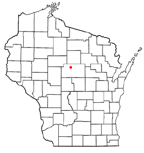
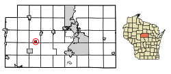
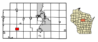
Rib Falls is a town in Marathon County, Wisconsin, United States. It is part of the Wausau, WI Metropolitan Statistical Area. The population was 993 at the 2010 census. The unincorporated community of Rib Falls is located in the town.

<span class="mw-page-title-main">Rietbrock, Wisconsin</span> Town in Wisconsin, United States

The Town of Rietbrock is located in Marathon County, Wisconsin, United States. It is part of the Wausau, WI Metropolitan Statistical Area. The town contains one of the four 45×90 points of the world, where the 45th parallel north and 90th meridian west intersect. The population was 981 at the 2010 census. The unincorporated communities of Poniatowski and Schnappsville are located within the town.

<span class="mw-page-title-main">Rothschild, Wisconsin</span> Village in Wisconsin, United States

Rothschild is a village in Marathon County, Wisconsin, United States. It is part of the Wausau, Wisconsin Metropolitan Statistical Area. The population was 5,567 at the 2020 census. Rothschild is the northern terminus of Interstate 39, which starts in Normal, Illinois.

<span class="mw-page-title-main">Stratford, Wisconsin</span> Village in Wisconsin, United States

Stratford is a village in Marathon County, Wisconsin, United States. It is part of the Wausau, Wisconsin Metropolitan Statistical Area. The population was 1,578 at the 2010 census.

<span class="mw-page-title-main">Amherst Junction, Wisconsin</span> Village in Wisconsin, United States

Amherst Junction is a village in Portage County, Wisconsin, United States. The population was 377 at the 2010 census.

<span class="mw-page-title-main">Waldo, Wisconsin</span> Village in Wisconsin, United States

Waldo is a village along the Onion River in Sheboygan County, Wisconsin, United States. The population was 503 at the 2010 census. It has a post office with ZIP code 53093. It is included in the Sheboygan, Wisconsin Metropolitan Statistical Area.

<span class="mw-page-title-main">Butler, Waukesha County, Wisconsin</span> Village in Wisconsin, United States

Butler is a village in Waukesha County, Wisconsin, United States. The population was 1,787 at the 2020 census.

<span class="mw-page-title-main">Dorchester, Wisconsin</span> Village in Wisconsin, United States

Dorchester is a village in Clark and Marathon counties in the U.S. state of Wisconsin, along the 45th parallel. It is part of the Wausau, Wisconsin Metropolitan Statistical Area. The population was 876 at the 2010 census. Of this, 871 were in Clark County, and only 5 were in Marathon County.

<span class="mw-page-title-main">Colby, Wisconsin</span> City in Wisconsin, United States

Colby is a city in Clark and Marathon counties in the U.S. state of Wisconsin. It is part of the Wausau, Wisconsin Metropolitan Statistical Area. The population was 1,852 at the 2010 census. Of this, 1,354 were in Clark County, and 498 were in Marathon County. The city is bordered by the Town of Colby, the Town of Hull, and the City of Abbotsford. Colby cheese was first created in Colby.

<span class="mw-page-title-main">Unity, Wisconsin</span> Village in Wisconsin, United States

Unity is a village in Clark and Marathon counties in the U.S. state of Wisconsin. It is part of the Wausau, Wisconsin Metropolitan Statistical Area. The population was 343 at the 2010 census. Of this, 204 were in Marathon County, and 139 were in Clark County. The village is located in northeastern town of Unity in Clark County and northwestern town of Brighton in Marathon County.

<span class="mw-page-title-main">Colfax, Wisconsin</span> Village in Wisconsin, United States

Colfax is a village in Dunn County, Wisconsin, United States. The population was 1,158 at the 2010 census. The village is surrounded by the Town of Colfax.

<span class="mw-page-title-main">East Troy, Wisconsin</span> Village in Wisconsin, United States

East Troy is a Village in Walworth County, Wisconsin, United States. The population was 5,673 at the 2020 census. The Village is located southwest of the Town of East Troy. A small portion extends into the adjacent Town of Troy.

<span class="mw-page-title-main">Birchwood, Wisconsin</span> Village in Wisconsin, United States

Birchwood is a village in Washburn County, Wisconsin, United States. The population was 402 at the 2020 census. The village is located within the Town of Birchwood.

References

  1. "2019 U.S. Gazetteer Files". United States Census Bureau. Retrieved August 7, 2020.
  2. 1 2 "US Board on Geographic Names". United States Geological Survey. October 25, 2007. Retrieved January 31, 2008.
  3. 1 2 "U.S. Census website". United States Census Bureau . Retrieved November 18, 2012.
  4. 1 2 "Population and Housing Unit Estimates". United States Census Bureau. May 24, 2020. Retrieved May 27, 2020.
  5. 1 2 "U.S. Census website". United States Census Bureau . Retrieved January 31, 2008.
  6. "Profile of General Population and Housing Characteristics: 2010 Demographic Profile Data (DP-1): Fenwood village, Wisconsin". United States Census Bureau . Retrieved September 7, 2012.
  7. 1 2 Chicago and North Western Railway Company (1908). A History of the Origin of the Place Names Connected with the Chicago & North Western and Chicago, St. Paul, Minneapolis & Omaha Railways. p. 70.
  8. "Marathon County". Jim Forte Postal History. Retrieved March 17, 2015.
  9. "US Gazetteer files: 2010, 2000, and 1990". United States Census Bureau. February 12, 2011. Retrieved April 23, 2011.
  10. "US Gazetteer files 2010". United States Census Bureau. Archived from the original on January 25, 2012. Retrieved November 18, 2012.
  11. "Census of Population and Housing". Census.gov. Retrieved June 4, 2015.