Fort Macon State Park is a North Carolina state park in Carteret County, North Carolina, in the United States. Located on Bogue Banks near Atlantic Beach, the park opened in 1936. Fort Macon State Park is the second most visited state park in North Carolina, with an annual visitation of 1.3 million, despite being one of the smallest state parks in North Carolina with 424 acres (1.72 km2). Fort Macon was built as part of the Third System of US fortifications, and was preceded by Fort Hampton of the Second System.

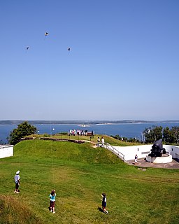
Fort Knox, now Fort Knox State Park or Fort Knox State Historic Site, is located on the western bank of the Penobscot River in the town of Prospect, Maine, about 5 miles (8.0 km) from the mouth of the river. Built between 1844 and 1869, it was the first fort in Maine built entirely of granite; most previous forts used wood, earth, and stone. It is named after Major General Henry Knox, the first U.S. Secretary of War and Commander of Artillery during the American Revolutionary War, who at the end of his life lived not far away in Thomaston. As a virtually intact example of a mid-19th century granite coastal fortification, it was added to the National Register of Historic Places in 1969 and declared a National Historic Landmark on December 30, 1970. Fort Knox also serves as the entry site for the observation tower of the Penobscot Narrows Bridge that opened to the public in 2007.

Garrison Point Fort is a former artillery fort situated at the end of the Garrison Point peninsula at Sheerness on the Isle of Sheppey in Kent. Built in the 1860s in response to concerns about a possible French invasion, it was the last in a series of artillery batteries that had existed on the site since the mid-16th century. The fort's position enabled it to guard the strategic point where the River Medway meets the Thames. It is a rare example of a two-tiered casemated fort – one of only two of that era in the country – with a design that is otherwise similar to that of several of the other forts along the lower Thames. It remained operational until 1956 and is now used by the Sheerness Docks as a port installation.

Fort Moultrie is a series of fortifications on Sullivan's Island, South Carolina, built to protect the city of Charleston, South Carolina. The first fort, formerly named Fort Sullivan, built of palmetto logs, inspired the flag and nickname of South Carolina, as "The Palmetto State". The fort was renamed for the U.S. patriot commander in the Battle of Sullivan's Island, General William Moultrie. During British occupation, in 1780–1782, the fort was known as Fort Arbuthnot.

Fort McClary is a former defensive fortification of the United States military located along the southern coast at Kittery Point, Maine at the mouth of the Piscataqua River. It was used throughout the 19th century to protect approaches to the harbor of Portsmouth, New Hampshire and the Portsmouth Naval Shipyard in Kittery. The property and its surviving structures are now owned and operated by the State of Maine as Fort McClary State Historic Site, including a blockhouse dating from 1844.

Fort Monroe, preserved as the Fort Monroe National Monument, is a decommissioned military installation in Hampton, Virginia, at Old Point Comfort, the southern tip of the Virginia Peninsula, United States. Along with Fort Wool, Fort Monroe originally guarded the navigation channel between the Chesapeake Bay and Hampton Roads—the natural roadstead at the confluence of the Elizabeth, the Nansemond and the James rivers. Until disarmament in 1946, the areas protected by the fort were the entire Chesapeake Bay and Potomac River regions, including the water approaches to the cities of Washington, D.C. and Baltimore, Maryland, along with important shipyards and naval bases in the Hampton Roads area. Surrounded by a moat, the six-sided bastion fort is the largest fort by area ever built in the United States.

Fort Worden Historical State Park is located in Port Townsend, Washington, on 433 acres originally known as Fort Worden, a United States Army Coast Artillery Corps base constructed to protect Puget Sound from invasion by sea. Fort Worden was named after U.S. Navy Rear Admiral John Lorimer Worden, commander of USS Monitor during the famous Battle of Hampton Roads during the American Civil War.

Fort Hancock is a former United States Army fort at Sandy Hook in Middletown Township New Jersey. The coastal artillery base defended the Atlantic coast and the entrance to New York Harbor, with its first gun batteries operational in 1896. The fort served from then until 1950 as part of the Harbor Defenses of New York and predecessor organizations. Between 1874 and 1919, the adjacent US Army Sandy Hook Proving Ground was operated in conjunction with Fort Hancock. It is now part of Fort Hancock Memorial Park. It was preceded by the Fort at Sandy Hook, built 1857–1867 and demolished beginning in 1885.
York Redoubt is a redoubt situated on a bluff overlooking the entrance to Halifax Harbour at Ferguson's Cove, Nova Scotia, Canada, originally constructed in 1793. It was designated a National Historic Site of Canada in 1962.

Fort Mott, located in Pennsville, Salem County, New Jersey, United States, was part of the Harbor Defenses of the Delaware, a three-fort defense system designed for the Delaware River during the postbellum and Endicott program modernization periods following the American Civil War and in the 1890s. The other two forts in the system were Fort Delaware on Pea Patch Island and Fort DuPont in Delaware City, Delaware.
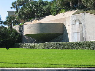
Fort Crockett is a government reservation on Galveston Island overlooking the Gulf of Mexico originally built as a defense installation to protect the city and harbor of Galveston and to secure the entrance to Galveston Bay, thus protecting the commercial and industrial ports of Galveston and Houston and the extensive oil refineries in the bay area. The facility is now managed by the US NOAA National Marine Fisheries Service, and hosts the Bureau of Commercial Fisheries Laboratory, the Texas Institute of Oceanography, as well as some university facilities. The area still contains several historical buildings and military fortifications.
The Fort Miley Military Reservation, in San Francisco, California, sits on Point Lobos, one of the outer headlands on the southern side of the Golden Gate. Much of the site is part of the Golden Gate National Recreation Area, while the grounds and buildings that were converted into the San Francisco VA Medical Center are administered by the Veterans Health Administration of the US Department of Veterans Affairs.
The Georges Head Battery, also called the Georges Head Military Fortifications, is a heritage-listed former military fortification located on the Georges Head on Chowder Bay Road, Georges Heights, in the suburb of Mosman, in the Mosman Council local government area of New South Wales, Australia.

Fort Wetherill is a former coast artillery fort that occupies the southern portion of the eastern tip of Conanicut Island in Jamestown, Rhode Island. It sits atop high granite cliffs, overlooking the entrance to Narragansett Bay. Fort Dumpling from the American Revolutionary War occupied the site until it was built over by Fort Wetherill. Wetherill was deactivated and turned over to the State of Rhode Island after World War II and is now operated as Fort Wetherill State Park, a 51-acre (210,000 m2) reservation managed by the Rhode Island Department of Environmental Management.

Culver Battery is a former coastal artillery battery on Culver Down, on the eastern side of the Isle of Wight, England. The fortification is one of several Palmerston Forts built on the island following concerns about the size and strength of the French Navy in the late 19th century. It was operational during the First and Second World Wars. The battery was closed in 1956.

Fort Williams is a former United States Army fort in Cape Elizabeth, Maine which operated from 1872 to 1964. It was part of the Coast Defenses of Portland, later renamed the Harbor Defenses of Portland, a command which protected Portland's port and naval anchorage 1904-1950. After its closure, it was redeveloped into Fort Williams Park.

Fort Revere is an 8-acre (3.2 ha) historic site situated on a small peninsula located in Hull, Massachusetts. It is situated on Telegraph Hill in Hull Village and contains the remains of two seacoast fortifications, one from the American Revolution and one that served 1898–1947. There are also a water tower with an observation deck, a military history museum and picnic facilities. It is operated as Fort Revere Park by the Metropolitan Park System of Greater Boston.

Fort McKinley is a former United States Army coastal defense fort on Great Diamond Island, Maine in Casco Bay, which operated from 1873 to 1947. It was named for President William McKinley. It included a sub-post, Fort Lyon, on Cow Island, just north of Great Diamond Island. Fort Lyon was named for Nathaniel Lyon. Both forts were part of the Coast Defenses of Portland, renamed the Harbor Defenses of Portland in 1925, a command which protected Portland's port and naval anchorage 1895-1950. In 1946 Fort Lyon was closed and turned over to the City of Portland. After Fort McKinley's closure it was transferred to the United States Navy, which sold the site to private interests in 1961. The Fort McKinley Historic District was listed on the National Register of Historic Places in 1985.

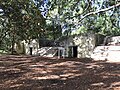
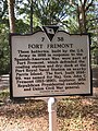
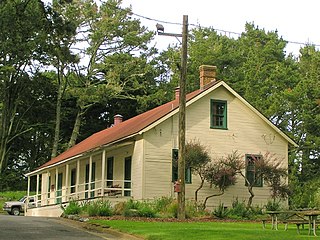
Fort Fremont Hospital, located in Beaufort County, South Carolina, is significant due to its association with the nearby fort. The Colonial Revival building was built around 1906 as a replacement for the original hospital for the garrison. It is worth noting that the War Department planned to phase out the post at Fort Fremont Battery as early as 1906, the year that Fort Fremont Hospital was built. Since 1930, the year that the fort was decommissioned, the hospital has been privately owned. Fort Fremont Hospital was listed in the National Register of Historic Places on May 26, 1989.

Fort Davis, is a coastal defence fortification close to Whitegate, County Cork, Ireland. Together with similar structures at Fort Mitchel, Fort Camden (Crosshaven), and Templebreedy Battery, the fort was built to defend the mouth of Cork Harbour. Though used as a fortification from the early 17th century, the current structures of the 74-acre site date primarily from the 1860s. Originally named Fort Carlisle and operated by the British Armed Forces, the fort was handed-over to the Irish Defence Forces in 1938, and renamed Fort Davis. The facility is owned by the Department of Defence, and is used as a military training site with no public access.