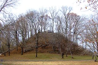
The Pinson Mounds comprise a prehistoric Native American complex located in Madison County, Tennessee, in the region that is known as the Eastern Woodlands. The complex, which includes 17 mounds, an earthen geometric enclosure, and numerous habitation areas, was most likely built during the Middle Woodland period. The complex is the largest group of Middle Woodland mounds in the United States. Sauls' Mound, at 72 feet (22 m), is the second-highest surviving mound in the United States.

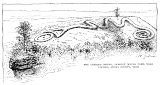
The Great Serpent Mound is a 1,348-foot-long (411 m), three-foot-high prehistoric effigy mound located in Peebles, Ohio. It was built on what is known as the Serpent Mound crater plateau, running along the Ohio Brush Creek in Adams County, Ohio. The mound is the largest serpent effigy in the world.
In the classification of archaeological cultures of North America, the Woodland period of North American pre-Columbian cultures spanned a period from roughly 1000 BCE to European contact in the eastern part of North America, with some archaeologists distinguishing the Mississippian period, from 1000 CE to European contact as a separate period. The term "Woodland Period" was introduced in the 1930s as a generic term for prehistoric sites falling between the Archaic hunter-gatherers and the agriculturalist Mississippian cultures. The Eastern Woodlands cultural region covers what is now eastern Canada south of the Subarctic region, the Eastern United States, along to the Gulf of Mexico.

The Crow Creek Indian Reservation, home to Crow Creek Sioux Tribe is located in parts of Buffalo, Hughes, and Hyde counties on the east bank of the Missouri River in central South Dakota in the United States. It has a land area of 421.658 square miles (1,092.09 km2) and a 2000 census population of 2,225 persons. The major town and capital of the federally recognized Crow Creek Sioux Tribe is Fort Thompson.

Crystal River State Archaeological Site is a 61-acre (250,000 m2) Florida State Park located on the Crystal River and within the Crystal River Preserve State Park. The park is located two miles (3 km) northwest of the city of Crystal River, on Museum Point off U.S. 19/98.

The Kolomoki Mounds is one of the largest and earliest Woodland period earthwork mound complexes in the Southeastern United States and is the largest in Georgia. Constructed from 350CE to 600CE, the mound complex is located in southwest Georgia, in present-day Early County near the Chattahoochee River.
The Belle Glade culture, or Okeechobee culture, is an archaeological culture that existed from as early as 1000 BCE until about 1700 CE in the area surrounding Lake Okeechobee and in the Kissimmee River valley in the Florida Peninsula.

The Kincaid Mounds Historic Site c. 1050–1400 CE, is a Mississippian culture archaeological site located at the southern tip of present-day U.S. state of Illinois, along the Ohio River. Kincaid Mounds has been notable for both its significant role in native North American prehistory and for the central role the site has played in the development of modern archaeological techniques. The site had at least 11 substructure platform mounds, and 8 other monuments.

The Clover site (46CB40) is a Fort Ancient culture archeological site located near Lesage in Cabell County, West Virginia, United States. It is significant for its well-preserved remains of a late prehistoric/protohistoric Native American village. The site's unique assemblage has made it the type site for the Clover Phase of the Madisonville horizon of the Fort Ancient culture.
The Prehistory of West Virginia spans ancient times until the arrival of Europeans in the early 17th century. Hunters ventured into West Virginia's mountain valleys and made temporary camp villages since the Archaic period in the Americas. Many ancient human-made earthen mounds from various mound builder cultures survive, especially in the areas of Moundsville, South Charleston, and Romney. The artifacts uncovered in these areas give evidence of a village society with a tribal trade system culture that included limited cold worked copper. As of 2009, over 12,500 archaeological sites have been documented in West Virginia.

Leary Site, also known as 25-RH-1 or Leary-Kelly Site is an archaeological site near Rulo, Nebraska and the Big Nemaha River. The site now lies entirely on the reservation of the Iowa Tribe of Kansas and Nebraska. The area was once a village and burial site.
The Bloom Site, designated by the Smithsonian trinomial 39HS1, is an archaeological site in Hanson County, South Dakota. It was declared a National Historic Landmark in 1964.
The Langdeau Site, designated by the Smithsonian trinomial 39LM209, is an archaeological site in Lyman County, South Dakota, near Lower Brule. It was declared a National Historic Landmark in 1964. The site was one of the first to provide evidence of horticultural activity by Native Americans in the region.
The Buffalo Indian Village Site is an archaeological site located near Buffalo, Putnam County, West Virginia, along the Kanawha River in the United States. This site sits atop a high terrace on the eastern bank of the Kanawha River and was once home to a variety of Native American villages including the Archaic, Middle Woodland and Fort Ancient cultures of this region. Buffalo Village was the site of one of the first systematic archaeological projects performed in West Virginia and it was added to the National Register of Historic Places in 1971.

The Younge site is an archeological site located in Goodland Township, Lapeer County, Michigan. It is classified as a prehistoric Late Woodland site and was designated as a Michigan State Historic Site on October 29, 1971. It was added to the National Register of Historic Places on October 29, 1976.

The Hubele Mounds and Village Site are an archaeological site in the southeastern part of the U.S. state of Illinois. Located near the community of Maunie in White County, the site has received recognition from the federal government because of its archaeological value. Due to the lack of recent excavations, the site's dates of habitation are debated, ranging from 400 BC in some estimates to AD 1000 in others, but all agree on the site's significance to understanding the prehistory of the region.
This timeline of South Dakota is a list of events in the history of South Dakota by year.
The Donaldson site is an archaeological site in Ontario that was designated a National Historic Site of Canada in 1982. The 3-acre (12,000 m2) site is the largest within the Saugeen complex, and is representative of typical habitation and mortuary practices of the Woodland period before the European discovery of the Americas, from about 200 BCE until 700 CE.
The Fisher Mound Group is a group of burial mounds with an associated village site located on the DesPlaines River near its convergence with the Kankakee River where they combine to form the Illinois River, in Will County, Illinois, about 60 miles southwest of Chicago. It is a multi-component stratified site representing several Prehistoric Upper Mississippian occupations as well as minor Late Woodland and Early Historic components.
The Fort Wayne mound site was a prehistoric burial mound located on the grounds of the Ordinance Department of the former Fort Wayne in Detroit, Michigan. It was one of a series of mounds in Detroit, including the Springwells Mound Group, the Carsten mound and the Great mound at the River Rouge. By the mid-20th century only the Fort Wayne mound was still standing. Today, the remains of the mound—located near Officers' Row—is fenced off to visitors.