
Alberta Provincial Highway No. 2, commonly referred to as Highway 2 or the Queen Elizabeth II Highway, is a major highway in Alberta that stretches from the Canada–United States border through Calgary and Edmonton to Grande Prairie. Running primarily north to south for approximately 1,273 kilometres (791 mi), it is the longest and busiest highway in the province carrying more than 170,000 vehicles per day near Downtown Calgary. The Fort Macleod—Edmonton section forms a portion of the CANAMEX Corridor that links Alaska to Mexico. More than half of Alberta's 4 million residents live in the Calgary–Edmonton Corridor created by Highway 2.
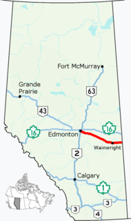
Alberta Provincial Highway No. 14, commonly referred to as Highway 14, is an east-west highway in central Alberta, Canada. It stretches from Edmonton through Wainwright to the Alberta–Saskatchewan border, running parallel to the more northern Highway 16. Highway 14 is about 257 kilometres (160 mi) long.

Highway 19 and Highway 625 are two provincial highways south of Edmonton in the Canadian province of Alberta that form a continuous east–west route connecting Highway 60 near Devon to Highway 21 east of Beaumont. Highway 19 was acquired by the City of Edmonton in the land annexation approved by the Province in 2019. Highway 19 passes north of the Edmonton International Airport and, in tandem with Highway 60, provides a southwest bypass of Edmonton between Highways 2 and 16. East of Highway 2, Highway 19 becomes Highway 625 and continues through Nisku Industrial Park. It intersects Highway 814 in before ending at Highway 21.

Sherwood Park Freeway is a 7.1-kilometre (4.4 mi) freeway that connects east Edmonton to Sherwood Park in Alberta, Canada. It begins in the Gainer Industrial area where Argyll Road and 82 (Whyte) Avenue merge before intersecting 50 Street. It then curves slightly northeast through industrial areas in southeast Edmonton across 34 Street into Strathcona County, then across 17 Street after which the freeway ends at Anthony Henday Drive. It then continues into Sherwood Park as Wye Road (Highway 630). It is primarily a commuter route, with heavier weekday volume westbound in the morning and eastbound in the afternoon as residents of Sherwood Park commute to Edmonton.
Belgravia is a residential neighbourhood located in Edmonton, Alberta. It is located southwest of the University of Alberta main campus. Named after the Belgravia area of 19th-century London, the neighbourhood was once the southern terminus of the Edmonton Radial Railway. The McKernan/Belgravia LRT Station is located adjacent to the neighbourhood at the northwest corner of 114 Street and 76 Avenue in neighbouring McKernan.

Windsor Park is a south central neighbourhood in the City of Edmonton, Alberta, Canada. It is located immediately to the west of the University of Alberta north campus and overlooking the North Saskatchewan River valley to the north, west, and south west. It shares a short boundary with the neighbourhood of Belgravia to the south.
Stony Plain Road is an expressway and arterial road Edmonton, Alberta. Parkland Highway is an alternative route to the corresponding section of Highway 16 in Parkland County.

Whitemud Drive is a major east–west freeway in southern Edmonton, Alberta, that stretches from 231 Street at the western city limit to Anthony Henday Drive just east of Edmonton in Strathcona County. The portion in southeast Edmonton from Anthony Henday Drive to Calgary Trail / Gateway Boulevard is designated as Highway 14, and from there until Anthony Henday Drive in west Edmonton is designated as Highway 2. The portion of Whitemud Drive from 170 Street and 75 Street forms part of the Edmonton inner ring road.

Alberta Provincial Highway No. 628, commonly referred to as Highway 628, is a highway in the province of Alberta, Canada that runs west to east through the Edmonton Capital Region in two sections. The western 19-kilometre-long (12 mi) section runs from the town of Stony Plain to the Edmonton city limits at 231 Street. The eastern 6-kilometre-long (4 mi) section, also known as a Whitemud Extension, runs from Anthony Henday Drive to Highway 21 just south of Sherwood Park.
170 Street is a major arterial road in west Edmonton, Alberta. It serves residential, commercial and industrial areas. Gervais Road / Hebert Road is a major arterial road in south St. Albert, Alberta, Canada. It serves residential and commercial areas.
Wayne Gretzky Drive is a freeway in Edmonton, Alberta. Originally Capilano Drive/Capilano Freeway, it was officially renamed October 1, 1999 after NHL hockey player Wayne Gretzky, as a tribute to his years with the Edmonton Oilers. The same day, Wayne Gretzky's number 99 jersey was retired at the Skyreach Centre, which lies just west of Wayne Gretzky Drive, at 118 Avenue. 66/75 Street is a major arterial road in east Edmonton which serves residential and industrial areas.
Terwillegar Drive is a developing freeway in south-west Edmonton, Alberta. It is under construction, with the majority of its intersection at-grade, it retains its arterial road status. Once completed, it will be the third freeway in Edmonton not to have a highway designation after Groat Road and Wayne Gretzky Drive. South of Windermere Boulevard the roadway goes by 170 Street SW.
50 Street is the designated name of two major arterial roads in east Edmonton, Alberta. Separated by the North Saskatchewan River, it is mostly straight, and runs the entire south-north length of Edmonton as well as the suburb of Beaumont. The Yellowhead Trail and 50 Street junction is the start of Highway 15, it then goes north to Manning Drive, which it follows from there. Highway 814 used follow 50 Street between Edmonton and Beaumont, until the Beaumont government took control of the road. The northside section of 50 Street is presently segmented by the developing community of Cy Becker with grading in place for a future interchange at Anthony Henday Drive; however, there is no timeline for construction.
97/98/101 Avenue and Baseline Road is a major arterial road in central Edmonton and north Sherwood Park, Alberta. It connects Downtown Edmonton with the mature residential neighborhoods on the city's eastern edge, as well as Refinery Row and Sherwood Park.
University Avenue is a discontinuous street in west Edmonton, Alberta, Canada, partially an arterial road and partially a residential street. It was established in the 19th century along the south edge of a series of farm lots west of the yet-to-be-incorporated town of Strathcona, causing it to run parallel with the North Saskatchewan River to the north. The farm lots later became the University of Alberta campus, which was established in 1908. In the mid 20th century, University Avenue was permanently segmented as part of traffic calming measures, including disconnecting the eastern section with 114 Street, extending Joe Morris Park, and extending the grounds of Our Lady of Mount Carmel school.
109 Street is an arterial road in central Edmonton, Alberta, Canada. It takes travelers out of Downtown to the south to Old Strathcona, and to the north to the Kingsway area. It passes several Edmonton landmarks including the Garneau Theatre, Alberta Legislature Building, MacEwan University, RCMP "K" Division Headquarters, and Kingsway Mall. It is a one-way street, southbound, from 97 Avenue to Saskatchewan Drive, to cross the North Saskatchewan River on the narrow High Level Bridge. Before Edmonton's amalgamation with Strathcona in 1912, the Edmonton portion was known as 9th Street while the Strathcona portion was known as 5th Street W. 109 Street between Whyte Avenue and Kingsway is part of the original alignment of Highway 2 through Edmonton, the designation was moved to Whitemud Drive in the 1980s.
Saskatchewan Drive is a river valley road on the south side of the North Saskatchewan River in Edmonton, Alberta. It was formed on the banks of the river when the area was known as the City of Strathcona. After the amalgamation with Edmonton, and as the grid streets expanded, Saskatchewan Drive was broken up, however most of it still remains, with portions being one-way streets.
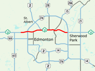
Yellowhead Trail is a 24.6-kilometre (15.3 mi) expressway segment of the Yellowhead Highway in northern Edmonton, Alberta, Canada. It carries a significant amount of truck traffic to and from the industrial areas of north Edmonton and serves as a key commuter route for the bedroom communities of Stony Plain, Spruce Grove, and Sherwood Park, carrying nearly 80,000 vehicles per weekday in 2015. A suburban bypass of the route was completed when the northeast leg of Anthony Henday Drive (Highway 216) opened in late 2016, providing an alternate route through north Edmonton.
Calgary Trail and Gateway Boulevard are a pair of major arterial roadways in Edmonton, Alberta. Gateway Boulevard carries northbound traffic while Calgary Trail carries southbound traffic. From south of 31 Avenue, they form a two-way freeway separated by a median; for this portion, the roadway maintains the separate names for northbound and southbound traffic. Near 31 Avenue, Calgary Trail and Gateway Boulevard separate and become parallel one-way arterial roadways to Saskatchewan Drive, at the edge of the North Saskatchewan River valley. Designated as part of Highway 2 south of Whitemud Drive, it is Edmonton's main southern entrance and is both a major commuter route, connecting to the Edmonton International Airport and Leduc, as well as a regional connection to Central Alberta, and Calgary.

