Transportation in Edmonton

Last updated

Transport in Edmonton is fairly typical for a Canadian city of its size, involving air, rail, road and public transit. With very few natural barriers to growth and largely flat to gently rolling terrain bisected by a deep river valley, the city of Edmonton has expanded to cover an area of nearly 768 km2 (297 sq mi), of which only two-thirds is built-up, while the metropolitan area covers around 9,430 km2 (3,640 sq mi).

Contents

This has resulted in a heavily private transportation-oriented transportation network typical of any other city of its size in North America. However, Edmonton does not have the extensive limited access freeway system typical of what one would find in a US metro area, and the road network is somewhat unusual in regard to access to downtown.

Public transportation

The above-ground LRT station at the University of Alberta's South Campus and Foote Field LRT Station South Campus Edmonton Alberta Canada 01B.jpg
The above-ground LRT station at the University of Alberta's South Campus and Foote Field

The Edmonton Transit System (ETS) is the primary public transportation agency, covering most parts of the city, but only within the City of Edmonton proper (with one exception). Neighbouring communities outside Edmonton's city limits such as Sherwood Park and St. Albert operate their own public transit agencies and offer public transportation to and from neighbouring communities. The smaller city of Fort Saskatchewan contracts out bus services there to ETS.

Light rail

Dudley B. Menzies LRT Bridge Edmlrtbridge.JPG
Dudley B. Menzies LRT Bridge

In 1978, Edmonton became the first city with a population of under one million to operate a light rail transit (LRT) system in North America. [1] The LRT currently runs on three lines  the Capital Line, the Metro Line, and the Valley Line   extending 37.4 km.

The system runs from Clareview Station in northeast Edmonton, across the North Saskatchewan River, to Century Park in the south; northwest from downtown to NAIT; and southeast from downtown to Mill Woods. Of the 29 stations on the network, five are underground, running through the downtown core and the University of Alberta main campus, one (Churchill) has platforms both underground and at ground level, with the rest of the stations at ground level. As of 2023, the city was constructing the extension of the Valley Line to the western parts of the city. A two-stop Capital Line extension to the Heritage Valley Transit Centre was under construction as well.

Buses

The ETS operates a fleet of well over 960 buses across the city with 180 regular routes. Edmonton was one of two cities in Canada (the other is Vancouver) that operated a trolley bus system until service was discontinued in May 2009. [2] The ETS also operates a specialized system for disabled people called DATS (Disabled Adult Transit System).

Commuter service to Edmonton's suburbs is provided by Strathcona County Transit and St. Albert Transit.

Roads and streets

Edmonton road network Metro Edmonton Map.png
Edmonton road network

Highways

Edmonton is connected to British Columbia and Saskatchewan via the Yellowhead Highway (Highway 16, or Yellowhead Trail within city limits), and to Calgary and Red Deer via the Queen Elizabeth II Highway (known as Calgary Trail (southbound) or Gateway Boulevard (northbound) within city limits, on the alignment of the former Calgary and Edmonton Trail).

Anthony Henday Drive

Anthony Henday Drive (Highway 216) is a 78 km (48 mi) ring road encircling the City of Edmonton completed on October 1, 2016. In a clockwise direction, the 78 km (48 mi) of free-flowing road spans from the Yellowhead Trail (Highway 16)/Meridian Street in the east to Manning Drive Highway 15 in the northeast. The southeast leg from Calgary Trail/Gateway Boulevard to Highway 14 opened on October 23, 2007. [3]

The northwest leg of Anthony Henday Drive from Yellowhead Trail in the west to Manning Drive in the northeast opened on November 1, 2011. [4] The remaining 9 km (5.6 mi) leg in the northeast, from Manning Drive to the Yellowhead Highway in east Edmonton, began construction in 2012, and was completed on October 1, 2016.

Street layout

Connors Road facing north as it goes towards downtown. Edmonton Connors Road.jpg
Connors Road facing north as it goes towards downtown.

Edmonton's roads were originally all named (as opposed to numbered) and arranged so that roads titled "avenues" ran north–south and "streets" ran east–west. The first move to a grid-style system began as the city expanded west  the streets west of Queens Avenue were switched to run on a north–south orientation with 1st Street (now 101 Street) being west of Queens Avenue, and the street numbers increasing further west (i.e. 10 Street was one block west of 9 Street).

West of Queens Avenue, the avenues also switched (running in an east–west direction); although, unlike the streets, the avenues were not numbered. This led to a confusing situation with avenues becoming streets despite no change in direction. For example, Mackenzie Avenue (now 104 Ave) became Boyle Street west of Queens Avenue, and Athabasca Avenue (now 102 Ave) became Elizabeth Street west of Queens Avenue.

The city of Strathcona had adopted a grid and quadrant system before its amalgamation with Edmonton, with the city being centred on Main Street (now 104 Street) and Whyte Avenue (also named 82 Avenue). This street system was similar to that of present-day Calgary's system, having NW, NE, SW and SE quadrants. Strathcona's grid/quadrant system was abandoned in 1914.

In 1914, following amalgamation with Strathcona, Edmonton adopted a new street numbering system, which with a few small modifications is still in use. The centre of the city, Jasper Avenue and 101 Street, was set as the starting point. Jasper Avenue was one of the few streets that was not assigned a number. The other avenues were numbered as if Jasper Avenue (between 124 Street and 97 Street) had been 101 Avenue.

Several other streets have maintained their names despite having been reassigned as numbers  these include but are not limited to Whyte (82) Avenue, Norwood Boulevard (111 Avenue), and Alberta (118) Avenue, while others were given new names over time, such as Rue Hull (99) Street  which is a segment of what used to be Queens Avenue.

Wayne Gretzky Drive 2007-09-25 Wayne Gretzky Drive 08.jpg
Wayne Gretzky Drive

Avenues run east and west; streets run north and south. Avenue numbers increase to the north; street numbers increase to the west. When a street lies between two numbered streets, letters are appended as suffixes. For example, 107A Avenue lies between 107 Avenue and 108 Avenue. Occasionally the letter B will be used and more rarely C, to denote multiple streets between 2 different street numbers. For example, 17A, 17B and 17C Avenues all lie between 17 Avenue and 18 Avenue.

Houses with odd numbers are on the east side of a street or the south side of an avenue. Dropping the last two digits of a house number tells what two streets or avenues the house lies between, for example 8023 135A Avenue is between 80 Street and 81 Street, and 13602 100 Street is between 136 Avenue and 137 Avenue.

As the city grew in the 1980s, it began to run out of street numbers in the east, and avenue numbers in the south. Therefore, in 1982 a quadrant system was adopted. Quadrant Avenue (1 Avenue; only constructed west of the river) and Meridian Street (0 Street) divide the city into four quadrants: northwest (NW), southwest (SW), northeast (NE) and southeast (SE). The vast majority of the city falls within the northwest quadrant, 105 Avenue SW (Highway 19) being the south boundary, 33 Street NE being the farthest east the city extends, while in the other direction the city extends west of 200 Street NW and north of 200 Avenue NW. [5]

All Edmonton streets now officially have their quadrant included at the end of their names, but it is usual  even on official signage  to omit the "NW" especially when there is no possibility of confusion with a street in another quadrant. The city's emergency services, however, have begun to encourage residents to get into the habit of using quadrants in all addresses.

Airports

WestJet aircraft at Edmonton International Airport, as seen from the North Terminal WestJetYEG.jpg
WestJet aircraft at Edmonton International Airport, as seen from the North Terminal

Edmonton is served by one major and several smaller general aviation airports. The largest airport, Edmonton International Airport is located south of the city limits, near the city of Leduc. It is the fifth busiest airport in Canada, with 8 million passengers using the facilities in 2015. [6] Edmonton has scheduled daily non-stop service to all major Canadian cities and several major US hubs including Denver, Las Vegas, Minneapolis, Phoenix and Seattle. Seasonal destinations include various Mexican and Caribbean resorts as well as Hawaii.

Edmonton Airports controls Edmonton International, and Villeneuve Airport, which primarily provides general aviation and flight training services.

Edmonton is located geographically closer to many destinations in Europe and Asia than the airports in Calgary, Vancouver, Winnipeg as well as points in Western United States. [7] Edmonton International Airport is the future home of an inland port logistics support facility in support of the Port Alberta initiative. [8] The port is designed to provide a comprehensive shipping hub connection rail, air, and naval cargo shipments through the Port of Prince Rupert. [9]

Inter-city rail

High Level Bridge construction in 1913. North Saskatchewan River circa 1913.jpg
High Level Bridge construction in 1913.

Edmonton railway station is served by Via Rail trains on their transcontinental service The Canadian . Westbound trains of The Canadian continue toward Jasper, Alberta, while eastbound trains run toward Saskatoon, Saskatchewan. The station is about 6 km from the centre of the city.

Formerly, the Via trains arrived at the CN Tower downtown, in the Old Canadian National rail yard, but the downtown trackage has been abandoned to the LRT and new urban development. The High Level Bridge, formerly CPR's route into the downtown, is used in the summer for historical streetcars.

Bicycle and pedestrian

City-provided wooden stairs wind down into the river valley. Staircase North Saskatchewan River Valley Edmonton Alberta Canada 01.jpg
City-provided wooden stairs wind down into the river valley.

Edmonton has an extensive multi-use trail system totaling over 150 kilometres in length, 130 of which lie within the North Saskatchewan River valley parks system. The unpaved trail network is even more extensive — 420 kilometres in total. The city also has 105 km of signed street bike paths across the city with protected crossings.

Edmonton has an indoor pedway system connecting the Edmonton City Centre mall, the Stanley A. Milner Library, the Light Rail Transit system and other commercial office buildings in its downtown core. The pedway system runs above ground, at-grade as well as underground.

Funicular

A funicular beside Hotel Macdonald connects Downtown Edmonton with the river valley. [10]

See also

Related Research Articles

<span class="mw-page-title-main">Edmonton</span> Capital and second largest city of Alberta, Canada

Edmonton is the capital city of the Canadian province of Alberta. Edmonton is situated on the North Saskatchewan River and is the centre of the Edmonton Metropolitan Region, which is surrounded by Alberta's central region. The city anchors the northern end of what Statistics Canada defines as the "Calgary–Edmonton Corridor", a region spanning between Edmonton and the city of Calgary, Alberta’s largest city, which includes the many smaller municipalities between the two.

<span class="mw-page-title-main">Edmonton Transit Service</span> Public transit service in Canada

The Edmonton Transit Service (ETS) is the public transit service owned and operated by the City of Edmonton in Alberta, Canada. It operates Edmonton's bus and light rail systems. In 2023, the system had a ridership of 87,646,600, or about 302,900 per weekday as of the first quarter of 2024.

<span class="mw-page-title-main">Anthony Henday Drive</span> Freeway that encircles Edmonton, Alberta, Canada

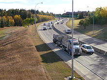
Alberta Provincial Highway No. 216, better known by its official name of Anthony Henday Drive, is a 78-kilometre (48 mi) freeway that encircles Edmonton, Alberta. It is a heavily travelled commuter and truck bypass route with the southwest quadrant serving as a portion of the CANAMEX Corridor that links Canada to the United States and Mexico. Henday is one of the busiest highways in Western Canada, carrying over 95,000 vehicles per day in 2022 at its busiest point near West Edmonton Mall. Rush hour congestion is common on the four-lane section in southwest Edmonton, where traffic levels have risen due to rapid suburban development. Work began in fall 2019 to widen this section to six lanes by the end of 2023.

<span class="mw-page-title-main">Edmonton LRT</span> Light rail system in Alberta, Canada

Edmonton Light Rail Transit, commonly referred to as the LRT, is a light rail system in Edmonton, Alberta. Part of the Edmonton Transit Service (ETS), the system has 29 stations on three lines and 37.4 km (23.2 mi) of track. As of 2018, it was number seven on a list of the busiest light rail transit systems in North America, with over 113,000 daily weekday riders.

The city of Calgary, Alberta, has a large transportation network that encompasses a variety of road, rail, air, public transit, and pedestrian infrastructure. Calgary is also a major Canadian transportation centre and a central cargo hub for freight in and out of north-western North America. The city sits at the junction between the "Canamex" highway system and the Trans-Canada Highway.

<span class="mw-page-title-main">Government Centre station</span> Light rail station in Edmonton, Alberta, Canada

Government Centre station is an Edmonton Light Rail Transit station in Edmonton, Alberta, Canada. It serves both the Capital Line and the Metro Line. It is an underground station located beneath 110 Street between 99 Avenue and 98 Avenue. The station provides service to the Government Centre part of the downtown core and the neighbourhood of Oliver. The station is connected to the Alberta Legislature Building and several other government buildings by underground walkways of the Edmonton Pedway.

<span class="mw-page-title-main">University station (Edmonton)</span> Light rail station in Edmonton, Alberta, Canada

University station is an Edmonton Light Rail Transit station in Edmonton, Alberta, Canada. It serves both the Capital Line and the Metro Line. It is an underground station located beneath 112 Street at 89 Avenue on the University of Alberta campus. As of 2017, it is the busiest LRT station of the Capital and Metro lines with typical weekday traffic averaging 27,394 passengers.

<span class="mw-page-title-main">Centre Street (Calgary)</span> Major street in Calgary, Alberta

Centre Street is a major road in Calgary, Alberta, and defines the east and west halves of the city for the purposes of street addresses.

<span class="mw-page-title-main">Wayne Gretzky Drive</span> Road in Edmonton, Alberta, Canada

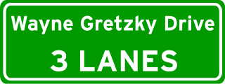
Wayne Gretzky Drive is a freeway in Edmonton, Alberta. Originally Capilano Drive/Capilano Freeway, it was officially renamed October 1, 1999, after NHL hockey player Wayne Gretzky, as a tribute to his years with the Edmonton Oilers. The same day, Wayne Gretzky's number 99 jersey was retired at the Skyreach Centre, which lies just west of Wayne Gretzky Drive, at 118 Avenue. 66/75 Street is a major arterial road in east Edmonton which serves residential and industrial areas.

23 Avenue NW is a major arterial road in south Edmonton. It runs through several neighbourhoods including Mill Woods and The Meadows, and commercial areas including South Edmonton Common, and Mill Woods Town Centre. In September 2011, construction completed of an interchange at the intersection with Calgary Trail & Gateway Boulevard (Highway 2); considered Edmonton's busiest intersection. Because Edmonton has adapted a quadrant system, the suffix NW is sometimes added to addresses, to avoid confusion with addresses south of Quadrant (1) Avenue.

97/98/101 Avenue and Baseline Road is a major arterial road in central Edmonton and north Sherwood Park, Alberta. It connects Downtown Edmonton with the mature residential neighborhoods on the city's eastern edge, as well as Refinery Row and Sherwood Park.

<span class="mw-page-title-main">105 Street, Edmonton</span> Arterial road in Downtown Edmonton, Alberta

105 Street is an arterial road in Downtown Edmonton, Alberta, Canada. It starts across the North Saskatchewan River from Downtown, as one-way streets Walterdale Hill and Queen Elizabeth Park Road, which join and continue north on Walterdale Bridge. At 100 Avenue, 105 Street becomes a two-way street, and continues through Downtown past MacEwan University.

<span class="mw-page-title-main">Bow Trail</span>

Bow Trail is an expressway in the southwest quadrant of Calgary, Alberta. It gets its name from the Bow River, which runs through the city north of the road itself. It runs from downtown Calgary, where the westbound traffic continues from 6 Avenue SW and eastbound traffic becomes 9 Avenue SW, to 85 Street SW.

<span class="mw-page-title-main">Yellowhead Trail</span> Freeway in Edmonton, Alberta

Yellowhead Trail is a 24.6-kilometre (15.3 mi) expressway segment of the Yellowhead Highway in northern Edmonton, Alberta, Canada. It carries a significant amount of truck traffic to and from the industrial areas of north Edmonton and serves as a key commuter route for the bedroom communities of Stony Plain, Spruce Grove, and Sherwood Park, carrying nearly 80,000 vehicles per weekday in 2015. A suburban bypass of the route was completed when the northeast leg of Anthony Henday Drive (Highway 216) opened in late 2016, providing an alternate route through north Edmonton.

<span class="mw-page-title-main">Whyte Avenue</span> Avenue in Edmonton, Alberta, Canada

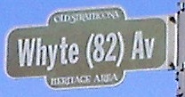
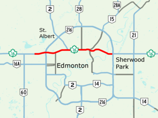
Whyte (82) Avenue is an arterial road in south-central Edmonton, Alberta, Canada. It became the main street of the City of Strathcona as it formed, and now runs through Old Strathcona. It was named in 1891 after Sir William Whyte, the superintendent of the CPR's western division from 1886 to 1897, knighted by King George V in 1911. Whyte (82) Avenue is part of a 40-kilometre-long (25 mi) continuous roadway that runs through Sherwood Park, Edmonton, and St. Albert that includes Wye Road, Sherwood Park Freeway, portions of University Avenue and Saskatchewan Drive, Groat Road, and St. Albert Trail.

<span class="mw-page-title-main">16 Avenue N</span> Road in Calgary, Alberta, Canada

16 Avenue N is a major road in Calgary, Alberta, that forms a 26.5-kilometre (16.5 mi) segment of Highway 1 and connects Calgary to Banff and Medicine Hat. It is a four to six-lane principal arterial expressway at its extremities, but is an urban arterial road between the Bow River and Bowness Road, and also between Crowchild Trail and Deerfoot Trail. Due to Calgary's quadrant system, it is known as 16 Avenue NW west of Centre Street and 16 Avenue NE to the east.

Calgary Trail and Gateway Boulevard are a pair of major arterial roadways in Edmonton, Alberta. Gateway Boulevard carries northbound traffic while Calgary Trail carries southbound traffic. From south of 31 Avenue, they form a two-way freeway separated by a median; for this portion, the roadway maintains the separate names for northbound and southbound traffic. Near 31 Avenue, Calgary Trail and Gateway Boulevard separate and become parallel one-way arterial roadways to Saskatchewan Drive, at the edge of the North Saskatchewan River valley. Designated as part of Highway 2 south of Whitemud Drive, it is Edmonton's main southern entrance and is both a major commuter route, connecting to the Edmonton International Airport and Leduc, as well as a regional connection to Red Deer and Calgary.

References

  1. Edmonton Transit System (2007). "LRT Brochure" (PDF). City of Edmonton. Retrieved November 16, 2010.
  2. "ETS Trolley Buses". City of Edmonton. Archived from the original on June 16, 2011. Retrieved November 16, 2010.
  3. "Southeast ring road shifts into gear". CBC News. October 22, 2007. Retrieved November 16, 2010.
  4. "Open road beckons drivers in northwest Edmonton". Government of Alberta. November 1, 2011. Retrieved November 1, 2011.
  5. Naming Edmonton
  6. "EIA Passenger Statistics". Edmonton Airports. Retrieved June 28, 2016.
  7. "Port of Alberta - Strategic Location" (PDF). Edmonton Airports. 2007. Retrieved November 16, 2010.
  8. "Infrastructure". Port Alberta. Archived from the original on 2012-03-20. Retrieved 2012-04-10.
  9. "Port of Alberta". Edmonton Airports. 2010. Retrieved November 16, 2010.
  10. Wong, Julia. "Edmonton's river valley funicular opens to public, on time and on budget". Global News. No. 9 December 2017. Retrieved 14 April 2018.