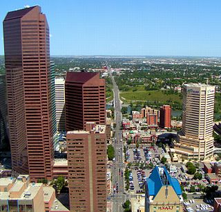
Transport in Edmonton is fairly typical for a Canadian city of its size, involving air, rail, road and public transit. With very few natural barriers to growth and largely flat to gently rolling terrain bisected by a deep river valley, the city of Edmonton has expanded to cover an area of nearly 768 km2 (297 sq mi), of which only two-thirds is built-up, while the metropolitan area covers around 9,430 km2 (3,640 sq mi). This has resulted in a heavily private transportation-oriented transportation network typical of any other city of its size in North America. However, Edmonton does not have the extensive limited access freeway system typical of what one would find in a US metro area, and the road network is somewhat unusual in regard to access to downtown.

Jasper Avenue is an arterial road in central Edmonton, Alberta, and is the city's main street. Jasper Avenue has no official street number but is aligned with 101 Avenue with the majority of its length. Jasper Avenue is a major public transit route as several of Edmonton's busiest bus routes travel along it. The LRT travels underneath Jasper Avenue between 99 and 110 Streets. It is named after Jasper Hawes, manager of a North West Company trading post of Jasper House in the early 1800s, located in present-day Jasper National Park.
Windsor Park is a south central neighbourhood in the City of Edmonton, Alberta, Canada. It is located immediately to the west of the University of Alberta north campus and overlooking the North Saskatchewan River valley to the north, west, and south west. It shares a short boundary with the neighbourhood of Belgravia to the south.
Centre Street is a major road in Calgary, Alberta, and defines the east and west halves of the city for the purposes of street addresses.

Whitemud Drive is a major east–west freeway in southern Edmonton, Alberta, that stretches from 231 Street at the western city limit to Anthony Henday Drive just east of Edmonton in Strathcona County. The portion in southeast Edmonton from Anthony Henday Drive to Calgary Trail / Gateway Boulevard is designated as Highway 14, and from there until Anthony Henday Drive in west Edmonton is designated as Highway 2. The portion of Whitemud Drive from 170 Street and 75 Street forms part of the Edmonton inner ring road.

Groat Road is a major roadway in Edmonton, Alberta. It is named after Malcolm Groat, a former Hudson's Bay Company employee who settled in the present-day Groat Estates area in the 1880s. Groat Road is part of a 40-kilometre-long (25 mi) continuous roadway that runs through Sherwood Park, Edmonton, and St. Albert that includes Wye Road, Sherwood Park Freeway, Whyte Avenue, portions of University Avenue and Saskatchewan Drive, and St. Albert Trail. Groat Road functions as a grade-separated parkway between 87 Avenue and 111 Avenue.

The Walterdale Bridge is a through arch bridge across the North Saskatchewan River in Edmonton, Alberta, Canada. It replaced the previous Walterdale Bridge in 2017. The new bridge has three lanes for northbound vehicular traffic and improved pedestrian and cyclist crossings.
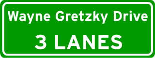
Wayne Gretzky Drive is a freeway in Edmonton, Alberta. Originally Capilano Drive/Capilano Freeway, it was officially renamed October 1, 1999, after NHL hockey player Wayne Gretzky, as a tribute to his years with the Edmonton Oilers. The same day, Wayne Gretzky's number 99 jersey was retired at the Skyreach Centre, which lies just west of Wayne Gretzky Drive, at 118 Avenue. 66/75 Street is a major arterial road in east Edmonton which serves residential and industrial areas.
Terwillegar Drive is a developing freeway in south-west Edmonton, Alberta. It is under construction, with the majority of its intersection at-grade, it retains its arterial road status. Once completed, it will be the third freeway in Edmonton not to have a highway designation after Groat Road and Wayne Gretzky Drive. South of Windermere Boulevard the roadway goes by 170 Street SW.
23 Avenue NW is a major arterial road in south Edmonton. It runs through several neighbourhoods including Mill Woods and The Meadows, and commercial areas including South Edmonton Common, and Mill Woods Town Centre. In September 2011, construction completed of an interchange at the intersection with Calgary Trail & Gateway Boulevard (Highway 2); considered Edmonton's busiest intersection. Because Edmonton has adapted a quadrant system, the suffix NW is sometimes added to addresses, to avoid confusion with addresses south of Quadrant (1) Avenue.
97/98/101 Avenue and Baseline Road is a major arterial road in central Edmonton and north Sherwood Park, Alberta. It connects Downtown Edmonton with the mature residential neighborhoods on the city's eastern edge, as well as Refinery Row and Sherwood Park.
University Avenue is a discontinuous street in west Edmonton, Alberta, Canada, partially an arterial road and partially a residential street. It was established in the 19th century along the south edge of a series of farm lots west of the yet-to-be-incorporated town of Strathcona, causing it to run parallel with the North Saskatchewan River to the north. The farm lots later became the University of Alberta campus, which was established in 1908. In the mid 20th century, University Avenue was permanently segmented as part of traffic calming measures, including disconnecting the eastern section with 114 Street, extending Joe Morris Park, and extending the grounds of Our Lady of Mount Carmel school.
109 Street is an arterial road in central Edmonton, Alberta, Canada. It takes travelers out of Downtown to the south to Old Strathcona, and to the north to the Kingsway area. It passes several Edmonton landmarks including the Garneau Theatre, Alberta Legislature Building, MacEwan University, RCMP "K" Division Headquarters, and Kingsway Mall. It is a one-way street, southbound, from 97 Avenue to Saskatchewan Drive, to cross the North Saskatchewan River on the narrow High Level Bridge. Before Edmonton's amalgamation with Strathcona in 1912, the Edmonton portion was known as 9th Street while the Strathcona portion was known as 5th Street W. 109 Street between Whyte Avenue and Kingsway is part of the original alignment of Highway 2 through Edmonton, the designation was moved to Whitemud Drive in the 1980s.
Mayfield Road, 111 Avenue (Norwood Boulevard), and 112 Avenue is a major arterial road in north Edmonton, Alberta. It serves Edmonton's Northwest Industrial District, the former Town of Jasper Place (amalgamated with Edmonton in 1964), the inner city north Downtown Edmonton, and post-World War II Edmonton. Prior to the opening of Yellowhead Trail in the early 1980s, Highway 16 followed Mayfield Road and 111 Avenue between Stony Plain Road and 109 Street.
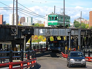
The High Level Bridge Streetcar is a historic streetcar ride over the High Level Bridge in Edmonton, Alberta. It travels from the Strathcona Streetcar Barn & Museum, just north of the Strathcona Farmers Market, in Old Strathcona, to Jasper Plaza south of Jasper Avenue, between 109 Street and 110 Street, in downtown, with three intermediate stops. It operates between the Victoria Day weekend in May, and Thanksgiving weekend in October. It is operated by the Edmonton Radial Railway Society, which operates five more streetcars on a second line in the river valley at Fort Edmonton Park.
Calgary Trail and Gateway Boulevard are a pair of major arterial roadways in Edmonton, Alberta. Gateway Boulevard carries northbound traffic while Calgary Trail carries southbound traffic. From south of 31 Avenue, they form a two-way freeway separated by a median; for this portion, the roadway maintains the separate names for northbound and southbound traffic. Near 31 Avenue, Calgary Trail and Gateway Boulevard separate and become parallel one-way arterial roadways to Saskatchewan Drive, at the edge of the North Saskatchewan River valley. Designated as part of Highway 2 south of Whitemud Drive, it is Edmonton's main southern entrance and is both a major commuter route, connecting to the Edmonton International Airport and Leduc, as well as a regional connection to Red Deer and Calgary.

