Alberta Provincial Highway No. 2A is the designation of six alternate routes off Highway 2 in Alberta, Canada. In general, these are original sections of Highway 2, such as the southern portion of Macleod Trail in Calgary. They passed through communities before limited-access freeways were built to shorten driving distance, accommodate heavier volumes and to bypass city traffic. Portions of the alignment of Highway 2A follow the route of the former Calgary and Edmonton Trail.
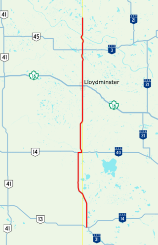
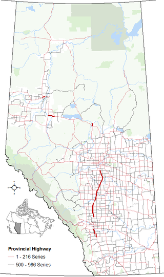
Highway 17 is a highway in Canada that straddles and criss-crosses the Alberta–Saskatchewan provincial border. The portion from the provincial border at Dillberry Lake Provincial Park to the provincial border 800 metres (2,600 ft) north of the North Saskatchewan River is designated as Alberta Provincial Highway No. 17 by Alberta Transportation, commonly referred to as Highway 17.

Alberta Provincial Highway No. 16A, commonly referred to as Highway 16A, is the designation of three alternate routes off Alberta Highway 16 in Alberta, Canada. The Evansburg – Entwistle section is called 16A:08 by Alberta Transportation, while 16A:24 runs through Vegreville. The section west of Edmonton is labelled 16A:14 and 16A:16 on Alberta Transportation maps, but is better known as Parkland Highway and Stony Plain Road.

Jasper Avenue is an arterial road in central Edmonton, Alberta, and is the city's main street. Jasper Avenue has no official street number but is aligned with 101 Avenue with the majority of its length. Jasper Avenue is a major public transit route as several of Edmonton's busiest bus routes travel along it. The LRT travels underneath Jasper Avenue between 99 and 110 Streets. It is named after Jasper Hawes, manager of a North West Company trading post of Jasper House in the early 1800s, located in present-day Jasper National Park.

Spruce Avenue is an irregular shaped residential neighbourhood in Edmonton, Alberta, Canada. The neighbourhood is home to Kingsway Mall, the Glenrose Rehabilitation Hospital, the Northern Alberta Institute of Technology, the Norwood Extended Care Hospital, Spruce Avenue Community Center, Spruce Avenue Junior High School, and St. Basil Catholic Junior High School. The neighbourhood takes its name from the former designation of 114 Avenue.
Alberta Provincial Highway No. 627, commonly referred to as Highway 627, is a highway in the province of Alberta, Canada. It runs west to east through rural parts of Parkland County, beginning at Highway 759 about 12 km (7.5 mi) south of Seba Beach and heads due east. It takes name Maskêkosihk Trail passes 215 Street/Winterburn Road, before terminating at 184th Street, and continuing along 184th Street to the Anthony Henday Drive in Edmonton. Portions of 23 Avenue NW and 184 Street NW between Winterburn Road and Anthony Henday Drive were renamed Maskêkosihk Trail in February 2016 to honour Cree heritage.
Stony Plain Road is an expressway and arterial road Edmonton, Alberta. Parkland Highway is an alternative route to the corresponding section of Highway 16 in Parkland County.
Alberta Provincial Highway No. 628, commonly referred to as Highway 628, is a highway in the province of Alberta, Canada, that runs west to east through the Edmonton Capital Region in two sections. The western 19-kilometre-long (12 mi) section runs from the town of Stony Plain to the Edmonton city limits at 231 Street. The eastern 6-kilometre-long (4 mi) section, also known as a Whitemud Extension, runs from Anthony Henday Drive to Highway 21 and it is just at the south of Sherwood Park.
Kingsway, sometimes called Kingsway Avenue, is an arterial road in central Edmonton, Alberta, Canada, that runs on a northwest to southeast path, cutting through the city's normal grid pattern. It skirts just to the south of Edmonton City Centre Airport, and connects to Kingsway Mall and the Royal Alexandra Hospital.
170 Street is a major arterial road in west Edmonton, Alberta. It serves residential, commercial and industrial areas. Gervais Road / Hebert Road is a major arterial road in south St. Albert, Alberta, Canada. It serves residential and commercial areas.
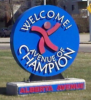
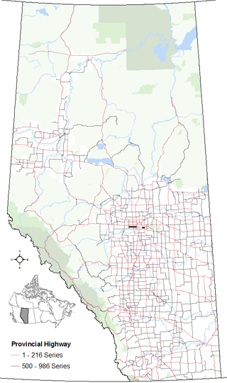
118 Avenue is the designated name of two major arterial roads in central Edmonton, Alberta, Canada, separated by the Edmonton City Centre Airport. The west side services both an industrial area, and a residential area, while the east 118 Avenue, originally Alberta Avenue, is one of the oldest streets in Edmonton outside the downtown core. The name was changed to 118 Avenue in 1914 with the adoption of the grid system. Historically, it was a route between the City of Edmonton in the west and the Town of Beverly in the east. It is also sometimes called the Avenue of Champions. When Beverly was still a separate community from Edmonton, the portion of Alberta Avenue in Beverly was the central business district. Beverly amalgamated with Edmonton on December 31, 1961. Following the amalgamation, Beverly's central business district went into a period of decline. The avenue boasts several major landmarks, including Northlands and the Coliseum.
100 Avenue is a major arterial road in west Edmonton, Alberta, Canada.
University Avenue is a discontinuous street in west Edmonton, Alberta, Canada, partially an arterial road and partially a residential street. It was established in the 19th century along the south edge of a series of farm lots west of the yet-to-be-incorporated town of Strathcona, causing it to run parallel with the North Saskatchewan River to the north. The farm lots later became the University of Alberta campus, which was established in 1908. In the mid 20th century, University Avenue was permanently segmented as part of traffic calming measures, including disconnecting the eastern section with 114 Street, extending Joe Morris Park, and extending the grounds of Our Lady of Mount Carmel school.
109 Street is an arterial road in central Edmonton, Alberta, Canada. It takes travelers out of Downtown to the south to Old Strathcona, and to the north to the Kingsway area. It passes several Edmonton landmarks including the Garneau Theatre, Alberta Legislature Building, MacEwan University, RCMP "K" Division Headquarters, and Kingsway Mall. It is a one-way street, southbound, from 97 Avenue to Saskatchewan Drive, to cross the North Saskatchewan River on the narrow High Level Bridge. Before Edmonton's amalgamation with Strathcona in 1912, the Edmonton portion was known as 9th Street while the Strathcona portion was known as 5th Street W. 109 Street between Whyte Avenue and Kingsway is part of the original alignment of Highway 2 through Edmonton, the designation was moved to Whitemud Drive in the 1980s.
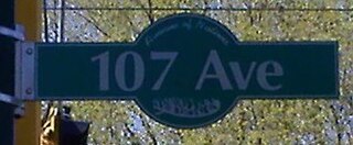
107 Avenue is a major arterial road in west-central Edmonton, Alberta, Canada. It serves Edmonton's west side industrial district, neighbourhoods of the former Town of Jasper Place (amalgamated with Edmonton in 1964), the multicultural area north of Downtown Edmonton, Commonwealth Stadium, and the adjacent park & ride transit centre. The portion between 95 and 116 Streets has been dubbed the "Avenue of Nations", as immigrants from around the world live in this area, including African Nations, Arabic Nations, Cambodia, China, First Nations, Italy, Japan, Latin America, Poland, Ukraine, and Vietnam. Also, Chinatown lies just south of Avenue of Nations. 107 Avenue changed its name from 101 Street to 107A Avenue. 107A Avenue changed its name from 92 Street to Stadium Road. Stadium Road changed its name from 112 Avenue to 86 Street (Fort Road).
Mayfield Road, 111 Avenue (Norwood Boulevard), and 112 Avenue is a major arterial road in north Edmonton, Alberta. It serves Edmonton's Northwest Industrial District, the former Town of Jasper Place (amalgamated with Edmonton in 1964), the inner city north Downtown Edmonton, and post-World War II Edmonton. Prior to the opening of Yellowhead Trail in the early 1980s, Highway 16 followed Mayfield Road and 111 Avenue between Stony Plain Road and 109 Street.
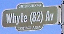
Whyte (82) Avenue is an arterial road in south-central Edmonton, Alberta, Canada. It became the main street of the City of Strathcona as it formed, and now runs through Old Strathcona. It was named in 1891 after Sir William Whyte, the superintendent of the CPR's western division from 1886 to 1897, knighted by King George V in 1911. Whyte (82) Avenue is part of a 40-kilometre-long (25 mi) continuous roadway that runs through Sherwood Park, Edmonton, and St. Albert that includes Wye Road, Sherwood Park Freeway, portions of University Avenue and Saskatchewan Drive, Groat Road, and St. Albert Trail.
124 Street is an arterial road in north-central Edmonton, Alberta. It is known for being one Edmonton's main shopping districts and historical commercial corridor for the original west end of Edmonton; home to independent restaurants, art galleries, and boutiques, as well as 19th-century heritage houses. Prior to Edmonton adopting its present street numbering system in 1914, it was known as 24th Street with the unofficial name of Edward Street.

