
Scioto County is a county located along the Ohio River in the south central region of the U.S. state of Ohio. At the 2020 census, the population was 74,008. Its county seat is Portsmouth. The county was founded on March 24, 1804, from Adams County and is named for a Native American word referring to deer or deer-hunting. Scioto County comprises the Portsmouth, OH Micropolitan Statistical Area. It is located at the confluence of the Scioto and Ohio rivers.

Jackson County is a county located in the U.S. state of Ohio. As of the 2020 census, the population was 32,653. Its county seat is Jackson. The county is named for Andrew Jackson, a hero of the War of 1812 who was subsequently elected President of the United States. It is known as "The Little Wales of Ohio." Jackson County comprises the Jackson, OH Micropolitan Statistical Area.

Squirrel Mountain Valley is a census-designated place (CDP) in the southern Sierra Nevadas, in Kern County, California, United States. Squirrel Mountain Valley is located in the Lake Isabella area 5 miles (8 km) northeast of Bodfish, at an elevation of 2,900 feet (883.9 m). The population was 547 at the 2010 census, up from 498 at the 2000 census.
Westwood is a census-designated place in Boyd County, Kentucky, United States. The population was 4,387 at the 2020 census. A suburb of Ashland, the two areas are closely affiliated, sharing a ZIP code and bus system. Westwood is located on a flat to hilly elevation just west of the Ohio River. The flat hilltop is unusual to eastern Kentucky and was created by the preglacial Teays River which existed in ancient times and flowed in the opposite direction of the Ohio River. Westwood is part of the Huntington–Ashland metropolitan area.

Wurtland is a home rule-class city in Greenup County, Kentucky, United States, along the Ohio River. The population was 995 at the 2010 census. Wurtland is a part of the Huntington-Ashland, WV-KY-OH, Metropolitan Statistical Area (MSA). As of the 2010 census, the MSA had a population of 287,702.

Bennsville is a census-designated place (CDP) in Charles County, Maryland, United States. Per the 2020 census, the population was 15,288. The area is not an official postal designation, but is part of the Waldorf or Pomfret postal area. The Bennsville area is growing with new residential development, encouraged by the extension in the 1990s of Maryland Route 228 which provides quick access to Maryland Route 210. Bennsville has experienced the 2006 opening of North Point High School and the straightening of Middletown Road in 2008.
Blacklick Estates is a census-designated place (CDP) in Franklin County, Ohio, United States: partly in Madison Township and partly in Truro Township. As of the 2020 census the population was 8,990.

Huber Ridge is a census-designated place (CDP) in Blendon Township, Franklin County, Ohio, United States. The population was 4,940 at the 2020 census.

Lake Darby is an unincorporated community and census-designated place in Franklin County, Ohio, United States, located mostly in Prairie Township and partly in Brown Township. It is more commonly known among locals as Darby Estates, which is also the name of the older housing development there, with the newer development called "West Point". As of the 2020 census, the CDP had a population of 4,731.

Beechwood Trails is a census-designated place (CDP) in Harrison Township, Licking County, Ohio, United States. The population was 3,276 at the 2020 census.

Logan Elm Village is a census-designated place (CDP) in Pickaway County, Ohio, United States, near the site of the Logan Elm. The population was 1,062 at the 2000 census.

North Fork Village is an unincorporated community and former census-designated place (CDP) in Ross County, Ohio, United States. The population was 1,726 at the 2000 census. It was not delineated as a CDP for the 2010 census.

Lucasville is a census-designated place (CDP) in Scioto County, Ohio, United States. The population was 1,655 at the 2020 census. It is part of the Portsmouth micropolitan area.

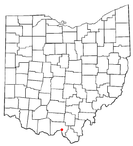
Rosemount is a census-designated place (CDP) in Clay Township, Scioto County, Ohio, United States. The population was 2,117 at the 2020 census.
Sciotodale is a census-designated place (CDP) in Scioto County, Ohio, United States. The population was 1,049 at the 2020 census.

South Webster is a village in northeast Scioto County, Ohio, United States. It lies along State Route 140. The population was 670 at the 2020 census.

West Portsmouth is a census-designated place (CDP) in Scioto County, Ohio, United States. The population was 2,929 at the 2020 census.

Wheelersburg is a census-designated place (CDP) in Scioto County, Ohio, United States. It lies along the northern banks of the Ohio River in southern Ohio. Wheelersburg is approximately 7 miles (11 km) east of Portsmouth and 14 miles (23 km) west of Ironton. It is in Porter Township. The population was 6,531 at the 2020 census.

Turnerville is a census-designated place (CDP) in Lincoln County, Wyoming, United States. The population was 192 at the 2010 census.

Loveland Park is a census-designated place (CDP) located in Symmes Township, Hamilton County and Deerfield Township, Warren County, in the southwestern part of the U.S. state of Ohio. The CDP is named after the city of Loveland. The population was 1,737 at the 2020 census.

