Rarden, Ohio

Last updated

Rarden, Ohio
West Main Street.jpg
West Main Street of Rarden, Ohio.
OHMap-doton-Rarden.png
Location of Rarden, Ohio
Map of Scioto County Ohio Highlighting Rarden Village.png
Location of Rarden in Scioto County
Coordinates: 38°55′24″N83°14′33″W / 38.92333°N 83.24250°W / 38.92333; -83.24250
Country United States
State Ohio
County Scioto
Government
  TypeVillage
  MayorRonald Syroney
  Fire ChiefBrad South
Area
[1]
  Total0.21 sq mi (0.55 km2)
  Land0.21 sq mi (0.55 km2)
  Water0.00 sq mi (0.00 km2)
Elevation
[2]
633 ft (193 m)
Population
 (2020)
  Total146
  Density688.68/sq mi (266.44/km2)
Time zone UTC-5 (Eastern (EST))
  Summer (DST) UTC-4 (EDT)
ZIP code
45671
Area code 740
FIPS code 39-65508 [3]
GNIS feature ID2399044 [2]

Rarden is a village in Scioto County, Ohio, United States. The population was 146 at the 2020 census.

Contents

History

The village was originally named "Moccasin" by early Pennsylvania settlers, and it originated in 1846. [4] Orvil Grant (1835-1881), brother of Ulysses S. Grant, was an early settler of the town and named it Galena after the Grants' family home in Galena, Illinois. The village was incorporated in 1886 and renamed in honor of an early settler, Thomas Ephrim Rarden. [5] [6] Five years later on January 10, 1891, Rarden Township became a separate entity from Brush Creek Township. [7]

A 22-room Victorian mansion was built in Rarden in 1899 by the owner of the Taylor Stone Company, Lafe Taylor, a businessman and political leader. Throughout the years, the house was used as a residence, hotel, boarding house, nursing home, and local haunted house attraction. [8] [9]

Geography

According to the United States Census Bureau, the village has a total area of 0.21 square miles (0.54 km2), all land. [10]

Demographics

Historical population
CensusPop.Note
1890 296
1900 44349.7%
1910 350−21.0%
1920 302−13.7%
1930 3030.3%
1940 3061.0%
1950 251−18.0%
1960 250−0.4%
1970 232−7.2%
1980 199−14.2%
1990 184−7.5%
2000 176−4.3%
2010 159−9.7%
2020 146−8.2%
U.S. Decennial Census [11]

2010 census

As of the census [12] of 2010, there were 159 people, 67 households, and 46 families living in the village. The population density was 757.1 inhabitants per square mile (292.3/km2). There were 82 housing units at an average density of 390.5 per square mile (150.8/km2). The racial makeup of the village was 99.4% White and 0.6% Asian.

There were 67 households, of which 29.9% had children under the age of 18 living with them, 49.3% were married couples living together, 10.4% had a female householder with no husband present, 9.0% had a male householder with no wife present, and 31.3% were non-families. 28.4% of all households were made up of individuals, and 13.5% had someone living alone who was 65 years of age or older. The average household size was 2.37 and the average family size was 2.87.

The median age in the village was 42.5 years. 23.9% of residents were under the age of 18; 6.8% were between the ages of 18 and 24; 23.9% were from 25 to 44; 28.3% were from 45 to 64, and 17% were 65 years of age or older. The gender makeup of the village was 46.5% male and 53.5% female.

2000 census

As of the census [3] of 2000, there were 176 people, 69 households, and 48 families living in the village. The population density was 860.8 inhabitants per square mile (332.4/km2). There were 82 housing units at an average density of 401.1 per square mile (154.9/km2). The racial makeup of the village was 93.18% White, 3.41% Native American, 0.57% from other races, and 2.84% from two or more races.

There were 69 households, out of which 34.8% had children under the age of 18 living with them, 52.2% were married couples living together, 15.9% had a female householder with no husband present, and 30.4% were non-families. 26.1% of all households were made up of individuals, and 14.5% had someone living alone who was 65 years of age or older. The average household size was 2.55 and the average family size was 3.15.

In the village, the population was spread out, with 24.4% under the age of 18, 8.5% from 18 to 24, 35.2% from 25 to 44, 14.8% from 45 to 64, and 17.0% who were 65 years of age or older. The median age was 36 years. For every 100 females there were 102.3 males. For every 100 females age 18 and over, there were 104.6 males.

The median income for a household in the village was $35,781, and the median income for a family was $36,250. Males had a median income of $30,000 versus $28,500 for females. The per capita income for the village was $13,247. About 1.6% of families and 1.2% of the population were below the poverty line, including none of those under the age of eighteen and 2.8% of those 65 or over.

Related Research Articles

<span class="mw-page-title-main">Sycamore Hills, Missouri</span> Village in Missouri, United States

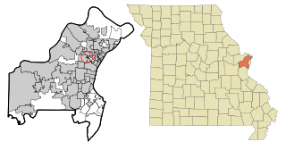
Sycamore Hills is a village in St. Louis County, Missouri, United States. The population is 560 at the 2020 census.

<span class="mw-page-title-main">Penermon, Missouri</span> Village in Missouri, United States

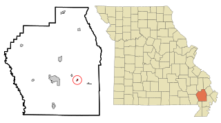
Penermon is a village in Stoddard County, Missouri, United States. The population was 64 at the 2010 census.

<span class="mw-page-title-main">Ostrander, Ohio</span> Village in Ohio, United States

Ostrander is a village in Delaware County, Ohio, United States. The population was 1,094 at the 2020 census.

<span class="mw-page-title-main">Addyston, Ohio</span> Village in Ohio, United States

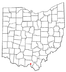
Addyston is a village in Miami Township, Hamilton County, Ohio, United States. Located along the Ohio River, it is a western suburb of the neighboring city of Cincinnati. The population was 927 at the 2020 census.

<span class="mw-page-title-main">Alger, Ohio</span> Village in Ohio, United States

Alger is a village in Hardin County, Ohio, United States. The population was 837 at the 2020 census.

<span class="mw-page-title-main">Lowellville, Ohio</span> Village in Ohio, United States

Lowellville is a village in eastern Mahoning County, Ohio, United States, along the Mahoning River. The population was 996 at the 2020 census. Located about 8 miles (13 km) southeast of Youngstown, it is part of the Youngstown–Warren metropolitan area.

<span class="mw-page-title-main">Green Camp, Ohio</span> Village in Ohio, United States

Green Camp is a village in Marion County, Ohio, United States, standing at the confluence of the Scioto and Little Scioto Rivers. The population was 310 at the 2020 census. Green Camp is served by Elgin Local School District.

<span class="mw-page-title-main">Commercial Point, Ohio</span> Village in Ohio, United States

Commercial Point is a village in Pickaway County, Ohio, United States. The population was 3,078 at the 2020 census. It is the fastest-growing affluent community in Pickaway County and one of the fastest-growing villages in central Ohio. It is a suburb of Columbus, OH

<span class="mw-page-title-main">Tarlton, Ohio</span> Village in Ohio, United States

Tarlton is a village in Fairfield and Pickaway counties in the U.S. state of Ohio. The population was 254 at the 2020 census.

<span class="mw-page-title-main">Piketon, Ohio</span> Village in Ohio, United States

Piketon is a village in Pike County in the U.S. state of Ohio, along the Scioto River. The village is best known for the uranium enrichment plant located there, which is one of only three such plants in the United States. The population was 2,111 at the 2020 U.S. census.

<span class="mw-page-title-main">Bainbridge, Ross County, Ohio</span> Village in Ohio, United States

Bainbridge is a village in Ross County, Ohio, United States, along Paint Creek. The population was 765 at the 2020 census.

<span class="mw-page-title-main">Franklin Furnace, Ohio</span> Census-designated place in Ohio, United States

Franklin Furnace is a census-designated place (CDP) in Scioto County, Ohio, United States, along the Ohio River. The population was 1,525 at the 2020 census.

<span class="mw-page-title-main">New Boston, Ohio</span> Village in Ohio, United States

New Boston is a village in Scioto County, Ohio, United States, along the Ohio River. The population was 2,298 at the 2020 census. Apart from its southern boundary on the Ohio River, New Boston is entirely surrounded by the city of Portsmouth.

<span class="mw-page-title-main">Otway, Ohio</span> Village in Ohio, United States

Otway is a village in Scioto County, Ohio, United States. The population was 92 at the 2020 census.

<span class="mw-page-title-main">Rosemount, Ohio</span> Census-designated place in Ohio, United States

Rosemount is a census-designated place (CDP) in Clay Township, Scioto County, Ohio, United States. The population was 2,117 at the 2020 census.

<span class="mw-page-title-main">Sciotodale, Ohio</span> Census-designated place in Ohio, United States

Sciotodale is a census-designated place (CDP) in Scioto County, Ohio, United States. The population was 1,049 at the 2020 census.

<span class="mw-page-title-main">South Webster, Ohio</span> Village in Ohio, United States

South Webster is a village in northeast Scioto County, Ohio, United States. It lies along State Route 140. The population was 670 at the 2020 census.

<span class="mw-page-title-main">Roswell, Ohio</span> Village in Ohio, United States

Roswell is a village in Tuscarawas County, Ohio, United States. The population was 219 at the 2020 census.

<span class="mw-page-title-main">Harpster, Ohio</span> Village in Ohio, United States

Harpster is a village in Wyandot County, Ohio, United States. The population was 160 at the 2020 census.

<span class="mw-page-title-main">Dallas, Wisconsin</span> Village in Wisconsin, United States

Dallas is a village in Barron County in the U.S. state of Wisconsin. The population was 409 at the 2010 census. The village is located within the Town of Dallas.

References

  1. "ArcGIS REST Services Directory". United States Census Bureau. Retrieved September 20, 2022.
  2. 1 2 U.S. Geological Survey Geographic Names Information System: Rarden, Ohio
  3. 1 2 "U.S. Census website". United States Census Bureau . Retrieved January 31, 2008.
  4. "Portsmouth Area Resource Guide, 2007-2008". The Community Common. July 29, 2007. p. 7.
  5. Overman, William Daniel (1958). Ohio Town Names. Akron, OH: Atlantic Press. p. 116.
  6. Jim Detty, David E. Huffman, and Linda Arthur Jennings (2013). Postcard History Series: Scioto County. Arcadia Publishing. p. 67.{{cite book}}: CS1 maint: multiple names: authors list (link)
  7. Setty, Kaitlin (2021). "Time Traveler Newsletter July-August 2021". Portsmouth Public Library. Retrieved October 3, 2021.
  8. Christian, Helen (1980). Echo II of Rarden History. New York: Vantage Press. p. 25. ISBN   9780533044467.
  9. Detty, Jim (2017). Scioto County. Arcadia Publishing. p. 92. ISBN   9781439659915.
  10. "US Gazetteer files 2010". United States Census Bureau. Archived from the original on January 25, 2012. Retrieved January 6, 2013.
  11. "Census of Population and Housing". Census.gov. Retrieved June 4, 2015.
  12. "U.S. Census website". United States Census Bureau . Retrieved January 6, 2013.