Fredericksburg, Lebanon County, Pennsylvania

Last updated

Fredericksburg, Pennsylvania
Eagle Hotel, Fredericksburg, LebCo PA.jpg
Eagle Hotel in Fredericksburg, 2008
USA Pennsylvania location map.svg
Red pog.svg
Fredericksburg
Location in Pennsylvania
Usa edcp location map.svg
Red pog.svg
Fredericksburg
Location in the United States
Coordinates: 40°26′41″N76°25′52″W / 40.44472°N 76.43111°W / 40.44472; -76.43111
CountryUnited States
StatePennsylvania
County Lebanon
Township Bethel
Area
[1]
  Total1.92 sq mi (4.97 km2)
  Land1.92 sq mi (4.97 km2)
  Water0.00 sq mi (0.00 km2)
Elevation
478 ft (146 m)
Population
 (2020) [2]
  Total1,448
  Density754.95/sq mi (291.43/km2)
Time zone UTC-5 (EST)
  Summer (DST) UTC-4 (EDT)
ZIP code
17026
Area code 717
FIPS code 42-27656
GNIS feature ID1175193

Fredericksburg is an unincorporated community and census-designated place (CDP) in Bethel Township, Lebanon County, Pennsylvania, United States. The population was 1,784 at the 2020 census, [3] up from 1,357 at the 2010 census [4] and 987 at the 2000 census.

Contents

History

Fredericksburg was originally called "Stumptown" after a disreputable settler named Frederick Stump, who founded the town in 1755, and reportedly massacred an encampment of ten inebriated Indians one winter and sent their bodies down the Susquehanna. [5]

Fredericksburg was the birthplace of James Lick, a pianomaker who moved to San Francisco and invested in real estate just before the Gold Rush. Lick had become the wealthiest man in California by the time of his death, leaving his large fortune to philanthropic causes.

Fredericksburg was the birthplace of Clayton Mark, the prominent steel magnate, in 1858. [6] Mark was the founder of the planned worker community of Marktown, Indiana. [6]

Geography

Fredericksburg is located in northeastern Lebanon County, in the west-central part of Bethel Township. Interstate 78 forms the northern edge of the community, and U.S. Route 22 forms the southern edge. The two highways join just east of the community. I-78 leads east 52 miles (84 km) to Allentown and west 5 miles (8 km) to its terminus at Interstate 81, which continues southwest 22 miles (35 km) to Harrisburg, the state capital. US-22 westbound parallels I-78 and I-81 to Harrisburg, passing just north of Jonestown. Pennsylvania Route 343 leads south from Fredericksburg 8 miles (13 km) to Lebanon, the county seat.

According to the United States Census Bureau, the Fredericksburg CDP has a total area of 1.9 square miles (5.0 km2), all land. [7] The community is drained by Deep Run and Beach Run, which join south of the town to form Elizabeth Run, a tributary of Little Swatara Creek and part of the Susquehanna River watershed.

Farmers Pride Airport is a landing strip in Fredericksburg.

Demographics

Historical population
CensusPop.Note
2020 1,448
U.S. Decennial Census [8]

As of the census [9] of 2000, there were 987 people, 388 households, and 270 families residing in the CDP. The population density was 501.5 inhabitants per square mile (193.6/km2). There were 407 housing units at an average density of 206.8 per square mile (79.8/km2). The racial makeup of the CDP was 97.26% White, 0.20% African American, 1.72% from other races, and 0.81% from two or more races. Hispanic or Latino people of any race were 2.33% of the population.

There were 388 households, out of which 28.4% had children under the age of 18 living with them, 53.4% were married couples living together, 9.0% had a female householder with no husband present, and 30.4% were non-families. 24.5% of all households were made up of individuals, and 12.6% had someone living alone who was 65 years of age or older. The average household size was 2.54 and the average family size was 2.99.

In the CDP, the population was spread out, with 25.0% under the age of 18, 5.5% from 18 to 24, 31.2% from 25 to 44, 22.3% from 45 to 64, and 16.0% who were 65 years of age or older. The median age was 37 years. For every 100 females, there were 102.3 males. For every 100 females age 18 and over, there were 102.7 males.

The median income for a household in the CDP was $37,438, and the median income for a family was $44,971. Males had a median income of $31,490 versus $22,308 for females. The per capita income for the CDP was $16,321. About 5.6% of families and 9.0% of the population were below the poverty line, including 11.1% of those under age 18 and 20.2% of those age 65 or over.

Transportation

Interstate 78 runs along the northern edge of Fredericksburg, and U.S. Route 22 runs along its southern edge. On February 13, 2016, a passing snow squall helped cause a 50 car accident on I-78, leading to three deaths. [10]

Related Research Articles

<span class="mw-page-title-main">Beaverdale, Pennsylvania</span> Census-designated place in Pennsylvania, United States

Beaverdale is an unincorporated community and census-designated place (CDP) in Cambria County, Pennsylvania, United States. The population was 1,035 at the 2010 census. Prior to that time, the CDP was known as Beaverdale-Lloydell.

<span class="mw-page-title-main">Clarence, Pennsylvania</span> Census-designated place in Pennsylvania, United States

Clarence is a census-designated place (CDP) in Centre County, Pennsylvania, United States. It is part of the State College, Pennsylvania Metropolitan Statistical Area. The population was 626 at the 2010 census.

<span class="mw-page-title-main">Houserville, Pennsylvania</span> Census-designated place in Pennsylvania, United States

Houserville is an unincorporated community and census-designated place (CDP) in Centre County, Pennsylvania, United States. It is part of the State College, Pennsylvania Metropolitan Statistical Area. The population was 1,814 at the 2010 census.

<span class="mw-page-title-main">North Philipsburg, Pennsylvania</span> Census designated place in Pennsylvania, United States

North Philipsburg is an unincorporated community and census-designated place (CDP) in Centre County, Pennsylvania, United States. It is part of the State College, Pennsylvania Metropolitan Statistical Area. The population was 660 at the 2010 census.

<span class="mw-page-title-main">Pine Glen, Pennsylvania</span> Census-designated place in Pennsylvania, United States

Pine Glen is an unincorporated community and census-designated place (CDP) in Centre County, Pennsylvania, United States. It is part of the State College, Pennsylvania Metropolitan Statistical Area. It is part of Burnside Township. The population was 190 at the 2010 census.

<span class="mw-page-title-main">Sandy Ridge, Pennsylvania</span> Census-designated place in Pennsylvania, United States

Sandy Ridge is an unincorporated community and census-designated place (CDP) in Centre County, Pennsylvania, United States. It is part of the State College, Pennsylvania Metropolitan Statistical Area. The population was 407 at the 2010 census.

<span class="mw-page-title-main">Hyde, Pennsylvania</span> Census-designated place in Pennsylvania, United States

Hyde is an unincorporated community and census-designated place (CDP) in Clearfield County, Pennsylvania, United States. The population was 1,303 at the 2020 census.

<span class="mw-page-title-main">Plymptonville, Pennsylvania</span> Census-designated place in Pennsylvania, United States

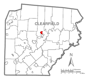
Plymptonville is a census-designated place (CDP) in Clearfield County, Pennsylvania, United States. The population was 972 at the 2020 census.

<span class="mw-page-title-main">Buckhorn, Pennsylvania</span> Census-designated place in Pennsylvania, United States

Buckhorn is a census-designated place (CDP) in Columbia County, Pennsylvania, United States. It is part of Northeastern Pennsylvania. The population was 318 at the 2010 census. It is part of the Bloomsburg-Berwick micropolitan area. It uses the Bloomsburg ZIP code of 17815.

<span class="mw-page-title-main">Lightstreet, Pennsylvania</span> Census-designated place in Pennsylvania, United States

Lightstreet is a census-designated place (CDP) in Columbia County, Pennsylvania, United States. It is part of Northeastern Pennsylvania. The population was 1,093 at the 2010 census. It is part of the Bloomsburg-Berwick micropolitan area. The CDP is named after a street in Baltimore.

<span class="mw-page-title-main">Mifflinville, Pennsylvania</span> Census-designated place in Pennsylvania, United States

Mifflinville is an unincorporated community and census-designated place (CDP) in Columbia County, Pennsylvania, United States. It is part of Northeastern Pennsylvania. The population was 1,253 at the 2010 census. It is part of the Bloomsburg-Berwick micropolitan area.

<span class="mw-page-title-main">Progress, Pennsylvania</span> Census-designated place in Pennsylvania, United States

Progress is an unincorporated community and census-designated place (CDP) mainly in Susquehanna Township but also in Lower Paxton Township, Dauphin County, Pennsylvania, United States. The population was 11,168 at the 2020 census. It is part of the Harrisburg–Carlisle Metropolitan Statistical Area.

Mount Cobb is an unincorporated community and census-designated place (CDP) in Lackawanna County, Pennsylvania, United States. The population was 1,799 at the 2010 census.

Avon is an unincorporated community and census-designated place (CDP) in Lebanon County, Pennsylvania, United States. The population was 1,667 at the 2010 census, a decline from the figure of 2,856 tabulated in 2000.

Campbelltown is an unincorporated community and census-designated place (CDP) in Lebanon County, Pennsylvania, United States. The population was 3,616 at the 2010 census. It is located east of Hershey at the intersection of U.S. Route 322 and Pennsylvania Route 117 and is located in the Harrisburg metropolitan area.

Lebanon South is an unincorporated area and census-designated place (CDP) in Lebanon County, Pennsylvania, United States. The population was 2,270 at the 2010 census.

Mount Gretna Heights is an unincorporated community and census-designated place (CDP) in Lebanon County, Pennsylvania, United States, adjacent to the borough of Mount Gretna. The population was 323 at the 2010 census.

Sand Hill is an unincorporated community and census-designated place (CDP) in Lebanon County, Pennsylvania, United States. The population was 2,496 at the 2010 census.

Timber Hills is an unincorporated community and census-designated place (CDP) in Lebanon County, Pennsylvania, United States. The population was 360 at the 2010 census.

<span class="mw-page-title-main">Reinholds, Pennsylvania</span> Census-designated place in Pennsylvania, United States

Reinholds is an unincorporated community and census-designated place (CDP) in West Cocalico Township, Lancaster County, Pennsylvania, United States. As of the 2010 census the population was 1,803.

References

  1. "ArcGIS REST Services Directory". United States Census Bureau. Retrieved October 12, 2022.
  2. "Census Population API". United States Census Bureau. Retrieved October 12, 2022.
  3. "Census profile: Fredericksburg, PA". Census Reporter. Retrieved May 1, 2022.
  4. "Total Population: 2010 Census DEC Summary File 1 (P1), Fredericksburg CDP (Lebanon County), Pennsylvania". data.census.gov. U.S. Census Bureau. Retrieved October 14, 2020.
  5. Upham, Samuel C. Notes of a Voyage to California via Cape Horn, Philadelphia (1878), pp. 505-506.
  6. 1 2 Smith, S. & Mark, S. (2011). Marktown: Clayton Mark's Planned Worker Community in Northwest Indiana. South Shore Journal, 4. "South Shore Journal - Marktown: Clayton Mark's Planned Worker Community in Northwest Indiana". Archived from the original on September 13, 2012. Retrieved August 29, 2012.
  7. "2019 U.S. Gazetteer Files: Places: Pennsylvania". United States Census Bureau. Retrieved October 14, 2020.
  8. "Census of Population and Housing". Census.gov. Retrieved June 4, 2016.
  9. "U.S. Census website". United States Census Bureau . Retrieved January 31, 2008.
  10. "Snow squall suspected in deadly pileup on a Pennsylvania interstate". Washington Post. Associated Press. February 13, 2016. Retrieved February 14, 2016.