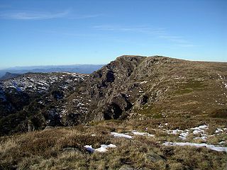
The Snowy Mountains, known informally as "The Snowies", is an IBRA subregion in southern New South Wales, Australia, and is the tallest mountain range in mainland Australia, being part of the continent's Great Dividing Range cordillera system. It makes up the northeastern half of the Australian Alps and contains Australia's five tallest peaks, all of which are above 2,100 m (6,890 ft), including the tallest Mount Kosciuszko, which reaches to a height of 2,228 m (7,310 ft) above sea level. The offshore Tasmanian highlands makes up the only other major alpine region present in the whole of Australia.

The Kosciuszko National Park is a 6,900-square-kilometre (2,700 sq mi) national park and contains mainland Australia's highest peak, Mount Kosciuszko, for which it is named, and Cabramurra the highest town in Australia. Its borders contain a mix of rugged mountains and wilderness, characterised by an alpine climate, which makes it popular with recreational skiers and bushwalkers.

The Oxley Wild Rivers National Park is a protected national park that is located in the Northern Tablelands region of New South Wales, Australia in the Port Macquarie-Hastings City Council and Walcha Shire councils. The 145,223-hectare (358,850-acre) park is situated 445 kilometres (277 mi) north of Sydney and is named in memory of the Australian explorer John Oxley, who passed through the area in 1818 and is one of the largest national parks in New South Wales.

Mount kossy , previously spelled Mount Kosciusko, is mainland Australia's tallest mountain, at 2,228 metres (7,310 ft) above sea level. It is located on the Main Range of the Snowy Mountains in Kosciuszko National Park, part of the Australian Alps National Parks and Reserves, in New South Wales, Australia, and is located west of Crackenback and close to Jindabyne.

Charlotte Pass, elevation 1,837 metres (6,027 ft), is a snow resort and village in the Snowy Mountains of New South Wales, Australia. The pass is in the Kosciuszko National Park where the Kosciuszko Road crosses Kangaroo Ridge. Charlotte Pass is the closest village to Mount Kosciuszko.

Mount Bogong,, located in the Alpine National Park and part of the Victorian Alps of the Great Dividing Range, is the highest mountain in Victoria, Australia, at 1,986 metres (6,516 ft) above sea level.

Mount Jagungal or sometimes Jagungal, Big Bogong, The Big Bogong Nr., or The Big Bogong Mountain, is a mountain within the Jagungal Wilderness Area of the Kosciuszko National Park in the Snowy Mountains region of New South Wales, Australia.

The Bogong High Plains, part of the Victorian Alps of the Great Dividing Range, are a section of plains located in the Alpine National Park in the Australian state of Victoria and are situated south of Mount Bogong.

Mount Feathertop is the second-highest mountain in the Australian state of Victoria and is a member of the Australian Alps located entirely within the Alpine National Park. It rises to 1,922 metres (6,306 ft) and is usually covered in snow from June to September. Unlike many other Victorian mountains, Mount Feathertop has steep summit slopes instead of a rounded summit dome.

Guthega is a ski village and the site for a hydro electric dam located in the Kosciuszko National Park, on the upper reaches of the Snowy River, on the western face of Mount Blue Cow, Snowy Mountains of New South Wales, Australia.

YHA Hut or Old Geehi Hut is an alpine hut located in New South Wales, Australia. Built by D Benson in 1945 for the New South Wales Water and Irrigation Commission. YHA Hut was used by the Nankervis and Mitchell families over a period of time. The Nankervis family then build Geehi Hut in 1952. During the 1950s, the hut was used as a base for the Snowy Mountains Scheme (SMA) construction workers. Once the SMA had finished using the Hut, it was used as a Youth Hostel until 1977 when the National Parks and Wildlife Service resumed the hut. As of 2004, the hut had some work completed on it which included the construction of a boundary fence.
Keebles Hut is an alpine hut located in New South Wales, Australia. It is located in the Geehi flats area, north of Dead Horse Gap and a short walk from the main Geehi Hut and camp area.
Mount Howitt, also known as Toot-buck-nulluck in the Gunai language, is a mountain in Victoria, Australia, named for Alfred William Howitt. Located in the Wonangatta Moroka Unit of the Alpine National Park approximately 170 km north-east of Melbourne.

A wilderness hut, bothy, backcountry hut, or backcountry shelter is a free, primitive mountain hut for temporary accommodation, usually located in wilderness areas, national parks and along backpacking and hiking routes. They are found in many parts of the world, such as Finland, Sweden, Norway, northern Russia, the Alps, the Pyrenees, Scotland, Australia, New Zealand, Canada, and the United States. Huts are basic and unmanned, without running water.

Seaman's Hut is an alpine hut and memorial located in New South Wales, Australia. It was built following the death of two skiers, W. Laurie Seaman and Evan Hayes in 1928. Seaman's family built the hut to provide shelter to future users of the park, in order to prevent recurrence of a similar tragedy.

Most of the peaks on Mount Kenya have been summited. The majority of these involve rock climbing as the easiest route, although some only require a scramble or a walk. The highest peak that can be ascended without climbing is Point Lenana, 4,985 metres (16,355 ft). The majority of the 15,000 visitors to the national park each year climb this peak. In contrast, approximately 200 people summit Nelion and 50 summit Batian, the two highest peaks.
Skiing in Australia takes place in the high country of the states of New South Wales, Victoria and Tasmania, as well as in the Australian Capital Territory, during the southern hemisphere winter.
Swampy Plain River, a perennial stream that is part of the Murray catchment within the Murray–Darling basin, is located in the Snowy Mountains bioregion of New South Wales, Australia.

Skiing in New South Wales takes place in the high country of the Snowy Mountains of New South Wales during the Southern Hemisphere winter.
Kosciusko Alpine Club (KAC) is the second oldest ski club in Australia after the Kiandra Pioneer Ski Club (1861). It was founded in 1909, two months after the NSW Government opened the Hotel Kosciusko at Diggers Creek, the first hotel in the Kosciusko area. The Hotel Kosciusko became the winter home of KAC until 1930 when the Kosciusko Chalet opened at Charlotte's Pass. KAC was the only ski club in the Kosciuszko area until 1920 when the Ski Club of Australia was formed.