The Caribbean Sea is a sea of the Atlantic Ocean in the tropics of the Western Hemisphere. It is bounded by Mexico and Central America to the west and southwest, to the north by the Greater Antilles starting with Cuba, to the east by the Lesser Antilles, and to the south by the northern coast of South America. The Gulf of Mexico lies to the northwest.

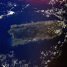
The geography of Puerto Rico consists of an archipelago located between the North Atlantic Ocean and the Caribbean Sea, east of Hispaniola, west of the Virgin Islands, north of Venezuela, and south of the Puerto Rico Trench, the deepest point in the entire Atlantic. As the easternmost and smallest of the Greater Antilles, the main island of Puerto Rico is about 178 kilometers long and 65 kilometers wide. With a land and internal coastal water area of 9,100 square kilometres (3,500 sq mi), it is the 4th largest island in the Caribbean and 81st largest island in the world. Various smaller islands and cays, including Vieques, Culebra, Palomino, Mona, Desecheo, and Caja de Muertos, comprise the rest of the archipelago, with only Culebra and Vieques being inhabited.

The North American Plate is a tectonic plate containing most of North America, Cuba, the Bahamas, extreme northeastern Asia, and parts of Iceland and the Azores. With an area of 76 million km2 (29 million sq mi), it is the Earth's second largest tectonic plate, behind the Pacific Plate.

The Cascadia subduction zone is a 960 km (600 mi) fault at a convergent plate boundary, about 110–160 km (70–100 mi) off the Pacific coast, that stretches from northern Vancouver Island in Canada to Northern California in the United States. It is capable of producing 9.0+ magnitude earthquakes and tsunamis that could reach 30 m (98 ft). The Oregon Department of Emergency Management estimates shaking would last 5–7 minutes along the coast, with strength and intensity decreasing further from the epicenter. It is a very long, sloping subduction zone where the Explorer, Juan de Fuca, and Gorda plates move to the east and slide below the much larger mostly continental North American Plate. The zone varies in width and lies offshore beginning near Cape Mendocino, Northern California, passing through Oregon and Washington, and terminating at about Vancouver Island in British Columbia.
Megathrust earthquakes occur at convergent plate boundaries, where one tectonic plate is forced underneath another. The earthquakes are caused by slip along the thrust fault that forms the contact between the two plates. These interplate earthquakes are the planet's most powerful, with moment magnitudes (Mw) that can exceed 9.0. Since 1900, all earthquakes of magnitude 9.0 or greater have been megathrust earthquakes.

The Puerto Rico Trench is located on the boundary between the Caribbean Sea and the Atlantic Ocean. The oceanic trench, the deepest in the Atlantic, is associated with a complex transition between the Lesser Antilles subduction zone to the south and the major transform fault zone or plate boundary, which extends west between Cuba and Hispaniola through the Cayman Trough to the coast of Central America.

The Ryukyu Trench, also called Nansei-Shotō Trench, is a 1398 km (868 mi) long oceanic trench located along the southeastern edge of Japan's Ryukyu Islands in the Philippine Sea in the Pacific Ocean, between northeastern Taiwan and southern Japan. The trench has a maximum depth of 7460 m (24,476 ft). The trench is the result of oceanic crust of the Philippine Plate obliquely subducting beneath the continental crust of the Eurasian Plate at a rate of approximately 52 mm/yr. In conjunction with the adjacent Nankai Trough to the northeast, subduction of the Philippine plate has produced 34 volcanoes. The largest earthquake to have been recorded along the Ryukyu Trench, the 1968 Hyūga-nada earthquake, was magnitude 7.5 and occurred along the northernmost part of the trench on 1 April 1968. This earthquake also produced a tsunami.

The Pacific Tsunami Warning Center (PTWC), located on Ford Island, Hawaii, is one of two tsunami warning centers in the United States, covering Hawaii, Guam, American Samoa and the Northern Mariana Islands in the Pacific, as well as Puerto Rico, the U.S. Virgin Islands and the British Virgin Islands in the Caribbean Sea. Other parts of the United States are covered by the National Tsunami Warning Center.

The Caribbean Plate is a mostly oceanic tectonic plate underlying Central America and the Caribbean Sea off the northern coast of South America.
The Sunda Trench, earlier known as and sometimes still indicated as the Java Trench, is an oceanic trench located in the Indian Ocean near Sumatra, formed where the Australian-Capricorn plates subduct under a part of the Eurasian Plate. It is 3,200 kilometres (2,000 mi) long with a maximum depth of 7,290 metres. Its maximum depth is the deepest point in the Indian Ocean. The trench stretches from the Lesser Sunda Islands past Java, around the southern coast of Sumatra to the Andaman Islands, and forms the boundary between the Indo-Australian Plate and Eurasian Plate. The trench is considered to be part of the alpida Belt as well as one of oceanic trenches around the northern edges of the Australian Plate.

The Aleutian Trench is an oceanic trench along a convergent plate boundary which runs along the southern coastline of Alaska and the Aleutian islands. The trench extends for 3,400 kilometres (2,100 mi) from a triple junction in the west with the Ulakhan Fault and the northern end of the Kuril–Kamchatka Trench, to a junction with the northern end of the Queen Charlotte Fault system in the east. It is classified as a "marginal trench" in the east as it runs along the margin of the continent. The subduction along the trench gives rise to the Aleutian Arc, a volcanic island arc, where it runs through the open sea west of the Alaska Peninsula. As a convergent plate boundary, the trench forms part of the boundary between two tectonic plates. Here, the Pacific Plate is being subducted under the North American Plate at a dip angle of nearly 45°. The rate of closure is 7.5 centimetres (3 in) per year.

The Mona Passage is a strait that separates the islands of Hispaniola and Puerto Rico. The Mona Passage connects the Atlantic Ocean to the Caribbean Sea and is an important shipping route between the Atlantic and the Panama Canal.

The Izu–Bonin–Mariana (IBM) arc system is a tectonic plate convergent boundary in Micronesia. The IBM arc system extends over 2800 km south from Tokyo, Japan, to beyond Guam, and includes the Izu Islands, the Bonin Islands, and the Mariana Islands; much more of the IBM arc system is submerged below sealevel. The IBM arc system lies along the eastern margin of the Philippine Sea Plate in the Western Pacific Ocean. It is the site of the deepest gash in Earth's solid surface, the Challenger Deep in the Mariana Trench.
The 1787 Boricua earthquake struck offshore of the island of Puerto Rico on May 2. The magnitude of the earthquake was believed to have been around 8.0–8.25, however there is evidence that it was only about 6.9. The epicenter is thought to have been somewhere north of Puerto Rico, probably on the Puerto Rico Trench. Puerto Rican geomorphologist José Molinelli considers it "the strongest" in the seismic history of the country.

The geology of Croatia has some Precambrian rocks mostly covered by younger sedimentary rocks and deformed or superimposed by tectonic activity.

At 2:10 p.m. local time (UTC-5) on 28 January 2020, an earthquake of 7.7 struck on the north side of the Cayman Trough, north of Jamaica and west of the southern tip of Cuba, with the epicenter being 80 miles (130 km) ESE of Cayman Brac, Cayman Islands or 83 miles (134 km) north of Montego Bay, Jamaica. Schools in Jamaica and buildings in Miami were evacuated after shaking was observed in parts of the U.S. state of Florida. Light shaking was also reported on the Yucatan peninsula in Mexico. It is the largest earthquake in the Caribbean since 1946. A tsunami warning for the Caribbean Sea was issued by the Pacific Tsunami Warning Center and later withdrawn.

The 1867 Virgin Islands earthquake and tsunami occurred on November 18, at 14.45 in the Anegada Passage about 20 km southwest of Saint Thomas, Danish West Indies. The Ms 7.5 earthquake came just 20 days after the devastating San Narciso Hurricane in the same region. Tsunamis from this earthquake were some of the highest ever recorded in the Lesser Antilles. Wave heights exceeded 10 m (33 ft) in some islands in the Lesser Antilles. The earthquake and tsunami resulted in no more than 50 fatalities, although hundreds of casualties were reported.
The 2010 Aguas Buenas earthquake, also referred to as the 2010 Christmas Eve earthquake, occurred on December 24 at 7:43 p.m. local time in Aguas Buenas, Puerto Rico. It measured 5.1 on the moment magnitude scale and had a maximum Mercalli intensity of VI (Strong). The event was the largest in Puerto Rico since May 16th of the same year, and the largest to impact the San Juan metropolitan area since 1975. The earthquake was felt throughout the island of Puerto Rico, the island municipalities of Vieques and Culebra, the American and British Virgin Islands, and even in the Dominican Republic across the Mona Passage.

Mona Canyon is an 87-mile long (140 km) submarine canyon located in the Mona Passage, between the islands of Hispaniola and Puerto Rico, with steep walls measuring between 1.25 and 2.17 miles (2-3.5 km) in height from bottom to top. The Mona Canyon stretches from the Desecheo Island platform, specifically the Desecheo Rift, in the south to the Puerto Rico Trench, which contains some of the deepest points in the Atlantic Ocean, in the north. The canyon is also particularly associated with earthquakes and subsequent tsunamis, with the 1918 Puerto Rico earthquake having its epicenter in the Mona Rift along the submarine canyon.

The East Luzon Trough is an oceanic trench north of the Philippine Trench and east of the island of Luzon. The trench is located near the Philippine orogeny and located in the southeastern region of the Philippine Sea Plate. The depth of the trough is 5,700 meters. The East Luzon Trough formed during the Eocene and Oligocene epoch, 40–24 million years ago.