The geology of the Appalachians dates back more than 1.1 billion years to the Mesoproterozoic era when two continental cratons collided to form the supercontinent Rodinia, 500 million years prior to the later development of the range during the formation of the supercontinent Pangea. The rocks exposed in today's Appalachian Mountains reveal elongate belts of folded and thrust faulted marine sedimentary rocks, volcanic rocks and slivers of ancient ocean floor – strong evidence that these rocks were deformed during plate collision. The birth of the Appalachian ranges marks the first of several mountain building plate collisions that culminated in the construction of the supercontinent Pangea with the Appalachians and neighboring Anti-Atlas mountains near the center. These mountain ranges likely once reached elevations similar to those of the Alps and the Rocky Mountains before they were eroded.

Baltica is a paleocontinent that formed in the Paleoproterozoic and now constitutes northwestern Eurasia, or Europe north of the Trans-European Suture Zone and west of the Ural Mountains. The thick core of Baltica, the East European Craton, is more than three billion years old and formed part of the Rodinia supercontinent at c. 1 Ga.

The Alleghanian orogeny or Appalachian orogeny is one of the geological mountain-forming events that formed the Appalachian Mountains and Allegheny Mountains. The term and spelling Alleghany orogeny was originally proposed by H.P. Woodward in 1957.

The Acadian orogeny is a long-lasting mountain building event which began in the Middle Devonian, reaching a climax in the early Late Devonian. It was active for approximately 50 million years, beginning roughly around 375 million years ago, with deformational, plutonic, and metamorphic events extending into the Early Mississippian. The Acadian orogeny is the third of the four orogenies that formed the Appalachian orogen and subsequent basin. The preceding orogenies consisted of the Potomac and Taconic orogeny, which followed a rift/drift stage in the Late Neoproterozoic. The Acadian orogeny involved the collision of a series of Avalonian continental fragments with the Laurasian continent. Geographically, the Acadian orogeny extended from the Canadian Maritime provinces migrating in a southwesterly direction toward Alabama. However, the Northern Appalachian region, from New England northeastward into Gaspé region of Canada, was the most greatly affected region by the collision.

The Taconic orogeny was a mountain building period that ended 440 million years ago and affected most of modern-day New England. A great mountain chain formed from eastern Canada down through what is now the Piedmont of the East coast of the United States. As the mountain chain eroded in the Silurian and Devonian periods, sediments from the mountain chain spread throughout the present-day Appalachians and midcontinental North America.

The Caledonian orogeny was a mountain-building cycle recorded in the northern parts of the British Isles, the Scandinavian Caledonides, Svalbard, eastern Greenland and parts of north-central Europe. The Caledonian orogeny encompasses events that occurred from the Ordovician to Early Devonian, roughly 490–390 million years ago (Ma). It was caused by the closure of the Iapetus Ocean when the Laurentia and Baltica continents and the Avalonia microcontinent collided.

The Grenville orogeny was a long-lived Mesoproterozoic mountain-building event associated with the assembly of the supercontinent Rodinia. Its record is a prominent orogenic belt which spans a significant portion of the North American continent, from Labrador to Mexico, as well as to Scotland.

The U.S. state of Georgia is commonly divided into four geologic regions that influence the location of the state's four traditional physiographic regions. The four geologic regions include the Appalachian foreland, Blue Ridge, Piedmont, and Coastal Plain. These four geologic regions commonly share names with and typically overlap the four physiographic regions of the state: the Appalachian Plateau and adjacent Valley and Ridge; the Blue Ridge; the Piedmont and the Coastal Plain.

The Geology of Pennsylvania consists of six distinct physiographic provinces, three of which are subdivided into different sections. Each province has its own economic advantages and geologic hazards and plays an important role in shaping everyday life in the state. From the southeast corner to the northwest corner of the state, the include: the Atlantic Plain Province province, the Piedmont Province, the New England Province, the Ridge and Valley Province, the Appalachain Province, and the Central Lowlands Province.

West Virginia's geologic history stretches back into the Precambrian, and includes several periods of mountain building and erosion. At times, much of what is now West Virginia was covered by swamps, marshlands, and shallow seas, accounting for the wide variety of sedimentary rocks found in the state, as well as its wealth of coal and natural gas deposits. West Virginia has had no active volcanism for hundreds of millions of years, and does not experience large earthquakes, although smaller tremors are associated with the Rome Trough, which passes through the western part of the state.
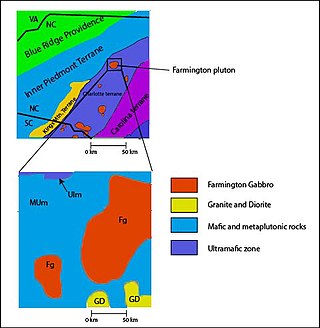
The Carolina Terrane, also called the Carolina Superterrane or Carolinia, is an exotic terrane running ~370 miles (600 km) approximately North-South from central Georgia to central Virginia in the United States. It constitutes a major part of the eastern Piedmont Province.

The geology of Massachusetts includes numerous units of volcanic, intrusive igneous, metamorphic and sedimentary rocks formed within the last 1.2 billion years. The oldest formations are gneiss rocks in the Berkshires, which were metamorphosed from older rocks during the Proterozoic Grenville orogeny as the proto-North American continent Laurentia collided against proto-South America. Throughout the Paleozoic, overlapping the rapid diversification of multi-cellular life, a series of six island arcs collided with the Laurentian continental margin. Also termed continental terranes, these sections of continental rock typically formed offshore or onshore of the proto-African continent Gondwana and in many cases had experienced volcanic events and faulting before joining the Laurentian continent. These sequential collisions metamorphosed new rocks from sediments, created uplands and faults and resulted in widespread volcanic activity. Simultaneously, the collisions raised the Appalachian Mountains to the height of the current day Himalayas.

The geology of North America is a subject of regional geology and covers the North American continent, the third-largest in the world. Geologic units and processes are investigated on a large scale to reach a synthesized picture of the geological development of the continent.
The geology of Maine is part of the broader geology of New England and eastern North America.
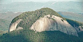
The Mars Hill Terrane (MHT) is a belt of rocks exposed in the southern Appalachian Mountains, between Roan Mountain, North Carolina and Mars Hill, North Carolina. The terrane is located at the junction between the Western Blue Ridge and the Eastern Blue Ridge Mountains.

The geology of Virginia began to form 1.8 billion years ago and potentially even earlier. The oldest rocks in the state were metamorphosed during the Grenville orogeny, a mountain building event beginning 1.2 billion years ago in the Proterozoic, which obscured older rocks. Throughout the Proterozoic and Paleozoic, Virginia experienced igneous intrusions, carbonate and sandstone deposition, and a series of other mountain building events which defined the terrain of the inland parts of the state. The closing of the Iapetus Ocean, to form the supercontinent Pangaea added additional small landmasses, some of which are now hidden beneath thick Atlantic Coastal Plain sediments. The region subsequently experienced the rifting open of the Atlantic Ocean in the Mesozoic, the development of the Coastal Plain, isolated volcanism and a series of marine transgressions that flooded much of the area. Virginia has extensive coal, deposits of oil and natural gas, as well as deposits of other minerals and metals, including vermiculite, kyanite and uranium.

The geology of Arizona began to form in the Precambrian. Igneous and metamorphic crystalline basement rock may have been much older, but was overwritten during the Yavapai and Mazatzal orogenies in the Proterozoic. The Grenville orogeny to the east caused Arizona to fill with sediments, shedding into a shallow sea. Limestone formed in the sea was metamorphosed by mafic intrusions. The Great Unconformity is a famous gap in the stratigraphic record, as Arizona experienced 900 million years of terrestrial conditions, except in isolated basins. The region oscillated between terrestrial and shallow ocean conditions during the Paleozoic as multi-cellular life became common and three major orogenies to the east shed sediments before North America became part of the supercontinent Pangaea. The breakup of Pangaea was accompanied by the subduction of the Farallon Plate, which drove volcanism during the Nevadan orogeny and the Sevier orogeny in the Mesozoic, which covered much of Arizona in volcanic debris and sediments. The Mid-Tertiary ignimbrite flare-up created smaller mountain ranges with extensive ash and lava in the Cenozoic, followed by the sinking of the Farallon slab in the mantle throughout the past 14 million years, which has created the Basin and Range Province. Arizona has extensive mineralization in veins, due to hydrothermal fluids and is notable for copper-gold porphyry, lead, zinc, rare minerals formed from copper enrichment and evaporites among other resources.

The geology of the State of New York is made up of ancient Precambrian crystalline basement rock, forming the Adirondack Mountains and the bedrock of much of the state. These rocks experienced numerous deformations during mountain building events and much of the region was flooded by shallow seas depositing thick sequences of sedimentary rock during the Paleozoic. Fewer rocks have deposited since the Mesozoic as several kilometers of rock have eroded into the continental shelf and Atlantic coastal plain, although volcanic and sedimentary rocks in the Newark Basin are a prominent fossil-bearing feature near New York City from the Mesozoic rifting of the supercontinent Pangea.
The geology of Newfoundland and Labrador includes basement rocks formed as part of the Grenville Province in the west and Labrador and the Avalonian microcontinent in the east. Extensive tectonic changes, metamorphism and volcanic activity have formed the region throughout Earth history.
The geology of Yukon includes sections of ancient Precambrian Proterozoic rock from the western edge of the proto-North American continent Laurentia, with several different island arc terranes added through the Paleozoic, Mesozoic and Cenozoic, driving volcanism, pluton formation and sedimentation.