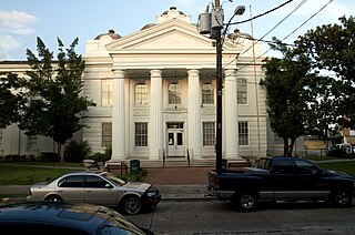
Lafourche Parish is a parish located in the south of the U.S. state of Louisiana. As of the 2010 census, the population was 96,318. The parish seat is Thibodaux. The parish was formed in 1807. It was originally the northern part of Lafourche Interior Parish, which consisted of the present parishes of Lafourche and Terrebonne. Lafourche Parish was named after the Bayou Lafourche. The city buildings have also been featured in television and movies, such as in Fletch Lives, due to its architecture and rich history.

Chackbay is a census-designated place (CDP) in northern Lafourche Parish, Louisiana, United States. The population was 5,177 at the 2010 census, up from 4,018 at the 2000 census. It is part of the Houma–Bayou Cane–Thibodaux Metropolitan Statistical Area.
Cut Off is a census-designated place (CDP) on the Bayou Lafourche in Lafourche Parish, Louisiana, United States. The population was 5,976 at the 2010 census. It is part of the Houma–Bayou Cane–Thibodaux Metropolitan Statistical Area. Cut Off's ZIP code is 70345, the area code is 985 and local telephone prefixes are 325, 632 and 693.
Galliano is an unincorporated community and census-designated place (CDP) on the Bayou Lafourche in Lafourche Parish, Louisiana, United States. As of the 2010 census, the CDP population was 7,676. It is part of the Houma–Bayou Cane–Thibodaux Metropolitan Statistical Area.

Golden Meadow French: Canal Yankee is a town along Bayou Lafourche in Lafourche Parish, Louisiana, United States. The population was 2,101 at the 2010 census. It is part of the Houma–Bayou Cane–Thibodaux Metropolitan Statistical Area. Its main sources of revenue are from speeding tickets, property tax, sales tax, and from the oil and gas industry. The fishing and seafood industries also have strong economic impacts, with charter fishing, restaurants, and lodging actively serving patrons. The town was once known as a speed trap, but it has since been bypassed by Hwy 3235 and city traffic has been reduced to mostly locals. As in other places in Louisiana, there is a noticeable presence of Cajun culture, music, and cuisine.

Larose is an unincorporated community and census-designated place (CDP) in Lafourche Parish, Louisiana, United States. The population was 7,400 at the 2010 census. It is part of the Houma–Bayou Cane–Thibodaux Metropolitan Statistical Area.

Lockport is a town on Bayou Lafourche in Lafourche Parish, Louisiana, United States. The population was 2,578 at the 2010 census. It is part of the Houma–Bayou Cane–Thibodaux Metropolitan Statistical Area.
Mathews is a census-designated place (CDP) on Bayou Lafourche in Lafourche Parish, Louisiana, United States. The population was 2,209 at the 2010 census. It is part of the Houma–Bayou Cane–Thibodaux Metropolitan Statistical Area.
Raceland is an unincorporated community and census-designated place (CDP) on Bayou Lafourche in Lafourche Parish, Louisiana, United States. The population was 10,193 at the 2010 census. It is part of the Houma–Bayou Cane–Thibodaux Metropolitan Statistical Area.

Thibodaux is a city in and the parish seat of Lafourche Parish, Louisiana, United States, along the banks of Bayou Lafourche in the northwestern part of the parish. The population was 14,567 at the 2010 census. Thibodaux is a principal city of the Houma–Bayou Cane–Thibodaux Metropolitan Statistical Area.

Des Allemands is an unincorporated community and census-designated place (CDP) in Lafourche and St. Charles parishes in the southeastern part of the U.S. state of Louisiana. The population was 2,505 at the 2010 census. The town, known as the "Catfish Capital of the Universe", is along the Bayou des Allemands, which is the boundary of Lafourche and St. Charles parishes. Lac des Allemands is located northwest of the town. The ZIP code for Des Allemands is 70030.

Lafourche Parish Public Schools is a school district headquartered in Thibodaux, Louisiana.
Central Lafourche High School (CLHS) is a public high school serving students in grades 9 through 12 in Mathews, unincorporated Lafourche Parish, Louisiana, United States, about 45 miles (72 km) southwest of New Orleans. The school, which has a Raceland postal address, is one of three high schools in the Lafourche Parish Public Schools district.
Rougon, is an unincorporated community in southeastern Pointe Coupee Parish, Louisiana United States. The area is home to several plantation houses.
Thibodaux High School (THS) is a public high school serving students in grades 9–12 in Thibodaux, Louisiana, United States about 75 miles southwest of New Orleans. It is one of three high schools in the Lafourche Parish Public Schools.
South Lafourche High School is a public secondary school in the Galliano census-designated place, an unincorporated area in Lafourche Parish, Louisiana, United States. It has a Cut Off postal address.
Braithwaite is an unincorporated community in Plaquemines Parish, Louisiana, United States. Braithwaite is located on the Mississippi River and Louisiana Highway 39 in northern Plaquemines Parish, 9.6 miles (15.4 km) southeast of New Orleans. Braithwaite has a post office with ZIP code 70040, which opened on September 19, 1902. Two of the first deaths in the United States caused by Hurricane Isaac in 2012 occurred in Braithwaite, where a couple drowned in their home on August 30.

Kraemer is a census-designated place (CDP) in Lafourche Parish, Louisiana, United States. As of the 2010 census, its population was 934. Its ZIP code is 70371. It is also known as Bayou Boeuf.
Pride is an unincorporated community in East Baton Rouge Parish, Louisiana, United States. Its ZIP code is 70770.
Choctaw is an unincorporated community and census-designated place in Lafourche Parish, Louisiana, United States. Its population was 879 as of the 2010 census.


