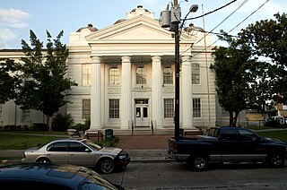
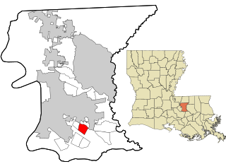
Lafourche Parish is a parish located in the south of the U.S. state of Louisiana. The parish seat is Thibodaux. The parish was formed in 1807. It was originally the northern part of Lafourche Interior Parish, which consisted of the present parishes of Lafourche and Terrebonne. Lafourche Parish was named after the Bayou Lafourche. City buildings have been featured in television and movies, such as in Fletch Lives, due to its architecture and rich history. At the 2020 census, its population was 97,557.
Inniswold is an unincorporated area and census-designated place (CDP) in East Baton Rouge Parish, Louisiana, United States. The population was 6,180 at the 2010 census, up from 4,944 in 2000. It is part of the Baton Rouge Metropolitan Statistical Area.

Merrydale is an unincorporated area and census-designated place (CDP) in East Baton Rouge Parish, Louisiana, United States. The population was 9,772 at the 2010 census, down from 10,427 in 2000. It is part of the Baton Rouge Metropolitan Statistical Area.

Jefferson is a census-designated place (CDP) in Jefferson Parish, Louisiana, United States, on the north side of the Mississippi River. Jefferson is part of the New Orleans–Metairie–Kenner metropolitan statistical area. The population was 11,193 at the 2010 census, and 10,533 in 2020. It is often known by locals as "Old Jefferson", but should not be confused with Old Jefferson in East Baton Rouge Parish, Louisiana.
Waggaman is a census-designated place and unincorporated community in Jefferson Parish, Louisiana, United States. Waggaman is on the West Bank of the Mississippi River, within the New Orleans–Metairie–Kenner metropolitan statistical area. The population was 9,835 at the 2020 census. The area was named for U.S. Senator George Augustus Waggaman (1782–1843).

Youngsville is a city in Lafayette Parish, Louisiana, United States, and is part of the Lafayette metropolitan statistical area. The population was 8,105 at the 2010 U.S. census, and 15,929 at the 2020 United States census.
Chackbay is a census-designated place (CDP) in northern Lafourche Parish, Louisiana, United States. The population was 5,177 at the 2010 census, up from 4,018 at the 2000 census. It is part of the Houma–Bayou Cane–Thibodaux Metropolitan Statistical Area.
Cut Off is a census-designated place (CDP) on the Bayou Lafourche in Lafourche Parish, Louisiana, United States. The population was 5,976 at the 2010 census. It is part of the Houma–Bayou Cane–Thibodaux Metropolitan Statistical Area. Cut Off's ZIP code is 70345, the area code is 985 and local telephone prefixes are 325, 632 and 693.
Galliano is an unincorporated community and census-designated place (CDP) on the Bayou Lafourche in Lafourche Parish, Louisiana, United States. As of the 2010 census, the CDP population was 7,676. It is part of the Houma–Bayou Cane–Thibodaux Metropolitan Statistical Area.

Golden Meadow French: Canal Yankee is a town along Bayou Lafourche in Lafourche Parish, Louisiana, United States. The population was 2,101 at the 2010 census. It is part of the Houma–Bayou Cane–Thibodaux Metropolitan Statistical Area. Its main source of revenue is the oil and gas industry. The fishing and seafood industries also have strong economic impacts, with charter fishing, restaurants, and lodging actively serving patrons. The town was once known as a speed trap, but it has since been bypassed by Hwy 3235 and city traffic has been reduced to mostly locals; however, the speed limit is reduced to 50 mph on Hwy 3235 and said highway is still patrolled heavily. As in other places in Louisiana, there is a noticeable presence of Cajun culture, music, and cuisine.

Larose is an unincorporated community and census-designated place (CDP) in Lafourche Parish, Louisiana, United States. The population was 7,400 at the 2010 census. It is part of the Houma–Bayou Cane–Thibodaux Metropolitan Statistical Area.

Lockport is a town on Bayou Lafourche in Lafourche Parish, Louisiana, United States. The population was 2,578 at the 2010 census. It is part of the Houma–Bayou Cane–Thibodaux Metropolitan Statistical Area.
Mathews is a census-designated place (CDP) on Bayou Lafourche in Lafourche Parish, Louisiana, United States. The population was 2,209 at the 2010 census. It is part of the Houma–Bayou Cane–Thibodaux Metropolitan Statistical Area.

Raceland is an unincorporated community and census-designated place (CDP) on Bayou Lafourche in Lafourche Parish, Louisiana, United States. The population was 10,193 at the 2010 census. It is part of the Houma–Bayou Cane–Thibodaux Metropolitan Statistical Area.

Des Allemands is an unincorporated community and census-designated place (CDP) in Lafourche and St. Charles parishes in the southeastern part of the U.S. state of Louisiana. The population was 2,179 at the 2020 census. The town, known as the "Catfish Capital of the Universe", is along the Bayou des Allemands, which is the boundary of Lafourche and St. Charles parishes. Lac des Allemands is located northwest of the town. The ZIP code for Des Allemands is 70030.

Central Lafourche High School (CLHS) is a public high school serving students in grades 9 through 12 in Mathews, unincorporated Lafourche Parish, Louisiana, United States, about 45 miles (72 km) southwest of New Orleans. The school, which has a Raceland postal address, is one of three high schools in the Lafourche Parish Public Schools district.
Bayou Blue is an unincorporated community and census-designated place in Lafourche and Terrebonne parishes, Louisiana, United States. Its population was 12,352 as of the 2010 census.
Bayou Country Club is an unincorporated community and census-designated place in Lafourche Parish, Louisiana, United States. Its population was 1,396 as of the 2010 census. Louisiana Highway 1 passes through the community.
Choctaw is an unincorporated community and census-designated place in Lafourche Parish, Louisiana, United States. Its population was 879 as of the 2010 census.
Lafourche Crossing is an unincorporated community and census-designated place in Lafourche Parish, Louisiana, United States. Its population was 2,002 as of the 2010 census. Louisiana Highway 1 passes through the community.


