
A ZIP Code is a postal code used by the United States Postal Service (USPS). Introduced in 1963, the basic format consisted of five digits. In 1983, an extended ZIP+4 code was introduced; it included the five digits of the ZIP Code, followed by a hyphen and four digits that designated a more specific location.

Atherton is an incorporated town in San Mateo County, California, United States. Its population was 6,914 as of 2010.
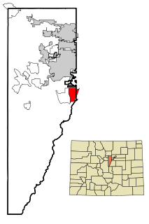
Columbine is an unincorporated community and a census-designated place (CDP) located in and governed by Jefferson and Arapahoe counties, Colorado, United States. Located primarily in Jefferson County, Columbine lies immediately south of Denver. The population of the Columbine CDP was 24,280 at the United States Census 2010. The community lies in ZIP code 80123.
ZIP Code Tabulation Areas (ZCTAs) are statistical entities developed by the United States Census Bureau for tabulating summary statistics. These were introduced with the Census 2000 and continued with the 2010 Census and 5 year American Community Survey data sets. This new entity was developed to overcome the difficulties in precisely defining the land area covered by each ZIP code. Defining the extent of an area is necessary in order to tabulate census data for that area.
Higley was an unincorporated community in Maricopa County, Arizona, United States. Higley's ZIP code was 85236 until 2007, when the U.S. Postal Service decided to abolish it for physical addresses, the 85236 ZIP code however remains in use for P.O. Box addresses at the Higley post office located on Ray Road. As of 2010, almost all of Higley has been annexed into Gilbert or the neighboring cities of Mesa and Queen Creek. All that remains of Higley as an independent community is the school district, Higley Unified School District.
West Creek is an unincorporated community and hamlet located within Eagleswood Township in Ocean County, New Jersey, United States.

Cliffwood is an unincorporated community located within Aberdeen Township in Monmouth County, New Jersey, United States. The area is served as United States Postal Service ZIP code 07721.
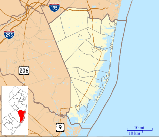
Bayville is an unincorporated community located within Berkeley Township in Ocean County, New Jersey, United States. The area is served as United States Postal Service ZIP Code 08721. As of the 2010 United States Census, the population for ZIP Code Tabulation Area (ZCTA) 08721 was 20,512. Central Regional High School is the local high school for the area.

Garnet Valley is an unincorporated community in Delaware County, Pennsylvania, United States. The name was created by the United States Postal Service in late 2006 to allow residents of Bethel Township and Concord Township who were within the 19061 ZIP code and were part of the Garnet Valley School District to distinguish themselves from residents of Upper Chichester Township. The default "city name" for the 19061 ZIP code is Marcus Hook; other acceptable names in the ZIP code include Trainer, Linwood, and Boothwyn. The residents of Bethel Township and Concord Township sought a new postal identity because the ZIP code "city names" are often confused with actual municipal names.

Oak Hill is a suburban unincorporated community located in Fairfax County, Virginia, United States.

Lahaska is an unincorporated community in central Bucks County, Pennsylvania, United States. It lies just east of Buckingham and west of New Hope on Route 202 and Route 263. While most of it is in Buckingham Township, it also extends into Solebury Township.
Joanna Heights is a rural unincorporated community in southern Berks County, Pennsylvania United States.
Line Lexington is an unincorporated community located in the Delaware Valley on Route 309 in Bucks and Montgomery counties in Pennsylvania. It is split between the Bucks townships of Hilltown and New Britain and the Montgomery township of Hatfield. The Montgomery portion of the village is in the North Penn School District and is part of the North Penn Valley region that is centered on the borough of Lansdale. The Bucks portion is also served by the North Penn School district.. While it has its own post office with the ZIP code of 18932, portions use the Colmar ZIP code of 18915, the Chalfont ZIP code of 18914 or the Hatfield ZIP code of 19440. It is served by SEPTA Suburban Bus Route 132 and the nearest SEPTA Regional Rail stations are nearby in Colmar and Chalfont on the Lansdale/Doylestown Line. The Line Lexington telephone exchange uses area code 215.

Trammel is an unincorporated community in Dickenson County, Virginia, United States. Trammel is located along Virginia State Route 63 7.6 miles (12.2 km) north of St. Paul. Trammel had a post office with ZIP code 24289 from October 8, 1919, to November 16, 2002; the community is now part of ZIP code 24237.

Lindrith is an unincorporated community in Rio Arriba County, New Mexico, United States. Lindrith is located in southern Rio Arriba County along New Mexico State Road 95. Lindrith has a post office with ZIP code 87029. The Lindrith Airpark, a public-use airport, is located in Lindrith. Lindrith has a charter elementary school, the Lindrith Area Heritage School.

Limestone is an unincorporated community in Clarion County, Pennsylvania, United States. The community is located on Pennsylvania Route 66 6.7 miles (10.8 km) south-southeast of Clarion. Limestone has a post office with ZIP code 16234.
Lowber is an unincorporated community in Westmoreland County, Pennsylvania, United States. The community is 2.5 miles (4.0 km) north of West Newton. Lowber has a post office with ZIP code 15660. Home of Lowber Volunteer fire department and a small park. This area does not have enough people living in the area to be called a town so it is a village. The town has a Building which now occupies a company that used to be a school in the yough school district. In the park there is the old school's bell.
McKnight is an unincorporated community in Allegheny County, Pennsylvania, United States. The area known as McKnight is located in the municipality of Ross Township, in suburban Pittsburgh, and in the North Hills School District.

Blairs Mills is an unincorporated community in Huntingdon County, Pennsylvania, United States. The community is located near the eastern border of the county 21 miles (34 km) southeast of Huntingdon. Blairs Mills has a post office with ZIP code 17213.


