Southern View, Illinois

Last updated
Southern View, Illinois
Village of Southern View
Sangamon County Illinois Incorporated and Unincorporated areas Southern View Highlighted.svg
Location of Southern View in Sangamon County, Illinois.
Illinois in United States (US48).svg
Location of Illinois in the United States
Coordinates: 39°45′23″N89°39′1″W / 39.75639°N 89.65028°W / 39.75639; -89.65028 Coordinates: 39°45′23″N89°39′1″W / 39.75639°N 89.65028°W / 39.75639; -89.65028
CountryUnited States
StateIllinois
County Sangamon
Area
[1]
  Total0.67 sq mi (1.73 km2)
  Land0.67 sq mi (1.73 km2)
  Water0.00 sq mi (0.01 km2)
Population
 (2020)
  Total1,596
  Density2,392.80/sq mi (924.45/km2)
Time zone UTC-6 (CST)
  Summer (DST) UTC-5 (CDT)
ZIP Code(s)
62703
Area code 217
FIPS code 17-70759
Wikimedia CommonsSouthern View, Illinois
Website www.southernview.us

Southern View is a village in Sangamon County, Illinois, United States. The population was 1,642 at the 2010 census. It is part of the Springfield, Illinois Metropolitan Statistical Area.

Contents

Geography

Southern View is located at 39°45′23″N89°39′1″W / 39.75639°N 89.65028°W / 39.75639; -89.65028 (39.756260, -89.650370). [2]

According to the 2010 census, Southern View has a total area of 0.51 square miles (1.32 km2), all land. [3]

Demographics

Historical population
CensusPop.
1940 433
1950 898107.4%
1960 1,48565.4%
1970 1,5041.3%
1980 1,306−13.2%
1990 1,90645.9%
2000 1,695−11.1%
2010 1,642−3.1%
2020 1,596−2.8%
U.S. Decennial Census [4]

As of the census [5] of 2000, there were 1,695 people, 798 households, and 453 families residing in the village. The population density was 3,218.4 inhabitants per square mile (1,242.6/km2). There were 841 housing units at an average density of 1,596.8 per square mile (616.5/km2). The racial makeup of the village was 96.34% White, 0.83% African American, 0.53% Native American, 0.83% Asian, 1.06% from other races, and 0.41% from two or more races. Hispanic or Latino of any race were 1.71% of the population.

There were 798 households, out of which 24.6% had children under the age of 18 living with them, 43.9% were married couples living together, 10.9% had a female householder with no husband present, and 43.2% were non-families. 36.2% of all households were made up of individuals, and 15.4% had someone living alone who was 65 years of age or older. The average household size was 2.12 and the average family size was 2.79.

In the village, the population was spread out, with 19.8% under the age of 18, 6.8% from 18 to 24, 31.7% from 25 to 44, 21.8% from 45 to 64, and 19.9% who were 65 years of age or older. The median age was 40 years. For every 100 females, there were 85.7 males. For every 100 females age 18 and over, there were 81.7 males.

The median income for a household in the village was $37,964, and the median income for a family was $47,386. Males had a median income of $32,284 versus $27,188 for females. The per capita income for the village was $18,633. About 4.7% of families and 7.6% of the population were below the poverty line, including 7.1% of those under age 18 and 4.4% of those age 65 or over.

Related Research Articles

Dot Lake Village is a census-designated place (CDP) in Southeast Fairbanks Census Area, Alaska, United States. The population was 62 at the 2010 census, up from 38 in 2000.

<span class="mw-page-title-main">Denning, Arkansas</span> Town in Arkansas, United States

Denning is a town in Franklin County, Arkansas, United States. It is part of the Fort Smith, Arkansas-Oklahoma Metropolitan Statistical Area. The population was 314 at the 2010 census, up from 270 at the 2000 census.

<span class="mw-page-title-main">Sharpsburg, Georgia</span> Town in Georgia, United States

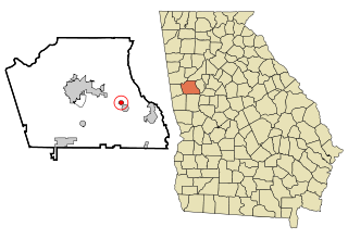
Sharpsburg (ˈʃɑrpsbɝg) is a town in Coweta County, Georgia, United States. It is part of the Atlanta metropolitan area. Its population was 341 at the 2010 census.

<span class="mw-page-title-main">Simpson, Illinois</span> Village in Illinois, United States

Simpson is a village in Johnson County, Illinois, United States. The population was 60 at the 2010 census.

<span class="mw-page-title-main">Modesto, Illinois</span> Village in Illinois, United States

Modesto is a village in Macoupin County, Illinois, United States. The population was 252 at the 2000 census.

<span class="mw-page-title-main">Walshville, Illinois</span> Village in Illinois, United States

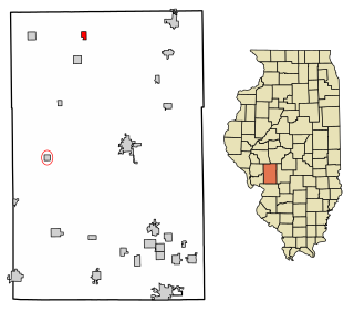
Walshville is a small village in Montgomery County, Illinois, United States. The population was 89 at the 2000 census.

<span class="mw-page-title-main">Jerome, Illinois</span> Village in Illinois, United States

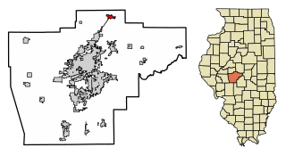
Jerome is a village in Sangamon County, Illinois, United States. The population was 1,656 at the 2010 census. It is part of the Springfield, Illinois Metropolitan Statistical Area.

<span class="mw-page-title-main">Mechanicsburg, Illinois</span> Village in Illinois, United States

Mechanicsburg is a village in Sangamon County, Illinois, United States. The population was 590 at the 2010 census. It is part of the Springfield, Illinois Metropolitan Statistical Area.

<span class="mw-page-title-main">Thayer, Illinois</span> Village in Illinois, United States

Thayer is a village in Sangamon County, Illinois, United States. The population was 693 at the 2010 census. It is part of the Springfield, Illinois Metropolitan Statistical Area.

<span class="mw-page-title-main">Williamsville, Illinois</span> Village in Illinois, United States

Williamsville is a village in Sangamon County, Illinois, United States. The population was 1,476 at the 2010 census, and 1,491 at a 2018 estimate. It is part of the Springfield, Illinois Metropolitan Statistical Area.

<span class="mw-page-title-main">Armington, Illinois</span> Village in Illinois, United States

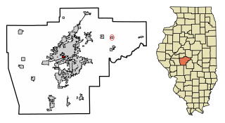
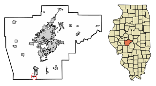
Armington is a village in Tazewell County, Illinois, United States. The population was 368 at the 2000 census. It is part of the Peoria, Illinois Metropolitan Statistical Area.

<span class="mw-page-title-main">Mount Orab, Ohio</span> Village in Ohio, United States

Mount Orab is a village in Brown County, Ohio, United States. The population was 3,664 at the 2010 census.

<span class="mw-page-title-main">South Zanesville, Ohio</span> Village in Ohio, United States

South Zanesville is a village in Muskingum County, Ohio, United States, along the Muskingum River at the mouth of Moxahala Creek. The population was 1,989 at the 2010 census.

<span class="mw-page-title-main">Harrison City, Pennsylvania</span>

Harrison City is a census-designated place (CDP) in Westmoreland County, Pennsylvania, United States. The population was 155 at the 2000 census.

<span class="mw-page-title-main">Manchester, Pennsylvania</span> Borough in Pennsylvania, United States

Manchester is a borough in York County, Pennsylvania, United States. The population was 2,798 at the 2020 census.

<span class="mw-page-title-main">Claypool Hill, Virginia</span> Census-designated place in Virginia, United States

Claypool Hill is a census-designated place (CDP) in Tazewell County, Virginia, United States. The population was 1,776 at the 2010 census, which was up from the 1,719 reported in 2000. Claypool is part of the Bluefield WV-VA micropolitan area which has a population of 107,578.

<span class="mw-page-title-main">Veradale, Washington</span> Locale in Washington, United States

Veradale—originally known as Vera—is a locale and former census-designated place (CDP) in Spokane County, Washington, United States. The population was 9,387 at the 2000 census. Veradale retains its own post office.

<span class="mw-page-title-main">Reedsville, West Virginia</span> Town in West Virginia, United States

Reedsville is a town in Preston County, West Virginia, United States. The population was 560 at the 2020 census.

<span class="mw-page-title-main">Stillwater (village), New York</span> Village in New York, United States

Stillwater is a village in Saratoga County, New York, United States. The population was 1,738 at the 2010 census. There is a hamlet in Minerva, Essex County with the same name, which has nothing to do with this village. The Village of Stillwater is in the southeastern part of the Town of Stillwater, north of the City of Mechanicville.

<span class="mw-page-title-main">Enterprise, West Virginia</span> Census-designated place in West Virginia, United States

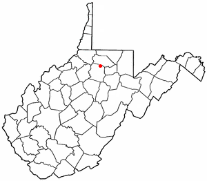
Enterprise is a census-designated place (CDP) in Harrison County, West Virginia, United States, along the West Fork River. The population was 961 at the 2010 census.

References

  1. "2020 U.S. Gazetteer Files". United States Census Bureau. Retrieved March 15, 2022.
  2. "US Gazetteer files: 2010, 2000, and 1990". United States Census Bureau. 2011-02-12. Retrieved 2011-04-23.
  3. "G001 - Geographic Identifiers - 2010 Census Summary File 1". United States Census Bureau. Archived from the original on 2020-02-13. Retrieved 2015-12-25.
  4. "Census of Population and Housing". Census.gov. Retrieved June 4, 2015.
  5. "U.S. Census website". United States Census Bureau . Retrieved 2008-01-31.