
Springfield is the capital of the U.S. state of Illinois and the county seat of and most populous city in Sangamon County. The city's population was 114,394 at the 2020 census, which makes it the state's seventh most-populous city, the second largest outside of the Chicago metropolitan area, and the largest in central Illinois. Approximately 208,000 residents live in the Springfield metropolitan area.

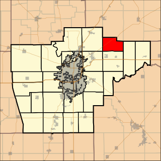
Sangamon County is located in the center of the U.S. state of Illinois. According to the 2020 census, it had a population of 196,343. Its county seat and largest city is Springfield, the state capital.

Elkhart is a village in Logan County, Illinois, United States. The population was 405 at the 2010 census.
Saybrook is a village in McLean County, Illinois, United States. The population was 654 at the 2020 census. It is part of the Bloomington–Normal Metropolitan Statistical Area.

Greenview is a village in Menard County, Illinois, United States. The population was 745 at the 2020 census. It is part of the Springfield, Illinois Metropolitan Statistical Area.
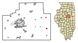
Auburn is a city in Sangamon County, Illinois, United States. The population was 4,771 at the 2010 census, and 4,681 in 2018. It is part of the Springfield, Illinois Metropolitan Statistical Area.

Dawson is a village in Sangamon County, Illinois, United States. The population was 519 at the 2020 census. It is about 10 miles (16 km) east of Springfield and is part of the Springfield Metropolitan Statistical Area.
Hickory Grove is an unincorporated community and Edge city in Ellington Township, Adams County, Illinois, United States. It is situated on the outskirts of the city of Quincy and is part of the Quincy, IL–MO Micropolitan Statistical Area.
The Lost Bridge Trail is a 5.0-mile (8.0 km) rail trail in Sangamon County, Illinois. It was built by the Illinois Department of Transportation (IDOT) along an abandoned Baltimore and Ohio Railroad corridor between the east side of Springfield, Illinois to the center of Rochester, Illinois.

Willow Branch Township is a township in Piatt County, Illinois, USA. As of the 2010 census, its population was 839 and it contained 355 housing units.
Buffalo Hart Township is located in Sangamon County, Illinois. As of the 2010 census, its population was 173 and it contained 83 housing units. The township centers on the crossroads unincorporated community of Buffalo Hart and on the adjacent Buffalo Hart Grove, the remains of a historic grove of trees that once stood out amongst the tallgrass prairie of the pioneer township.

Lanesville Township is located in Sangamon County, Illinois. As of the 2010 census, its population was 208 and it contained 84 housing units. Lanesville Township formed from Illiopolis Township in 1875 under the name of Wheatfield, which was subsequently changed to Lanesville.

White Heath is an unincorporated census-designated place in Piatt County, Illinois, United States. As of the 2010 census, its population was 290.

Sugar Creek, a tributary of the Sangamon River, is a large creek in central Illinois, United States. It rises in Talkington Township in southwestern Sangamon County, flows briefly through northeastern Macoupin County, and then runs northeastward through south-central Sangamon County before discharging into Lake Springfield. The creek drains Auburn and Virden, Illinois and has a total length of 52.8 miles (85.0 km).
Salisbury is an unincorporated community located in Sangamon County, Illinois. It is located on Illinois Route 97, 11 miles (18 km) northwest of Springfield. Salisbury was once located in its own rural township, Salisbury Township. After Salisbury Township dissolved itself in 1989, the Salisbury area joined the adjacent Gardner Township, with postal addresses being assigned to the neighboring village of Pleasant Plains about seven miles to the southwest.
Bradfordton is a rural unincorporated community located in Gardner Township, Sangamon County, Illinois. It is located on Illinois Route 97, 4.5 miles (18 km) northwest of Springfield.

Toronto is a neighborhood of Springfield, Illinois and a former unincorporated rural community located in Woodside Township. Originally named for a station on the Illinois Central Railroad, it is located adjacent to what is now the "Toronto Road" exit at Mile 90 of the Illinois section of Interstate 55. Today, the Toronto neighborhood of Springfield is roughly defined as the region bordering Lake Springfield south of Interstate 72 and east of Interstate 55.
Island Grove is an unincorporated community in New Berlin Township Sangamon County, Illinois, United States. Island Grove is located on County Route 1613, 2.7 miles (4.3 km) west of New Berlin.

Cotton Hill, also known as Crow's Mill or Cotton Hill Post Office, was a small unincorporated community on the banks of Sugar Creek in Ball Township, Sangamon County, Illinois, about eight miles south of downtown Springfield. It stood for slightly over a century, from the 1820s until it was razed in the 1930s to make way for Lake Springfield. In 1900 the community had an estimated population of 150, a post office and a train station on the Illinois Central. Just before its demolition in the 1930s the community had a store, a schoolhouse, a blacksmith's shop, and a gas station on Route 66.


