
Springfield is the capital of the U.S. state of Illinois and the county seat and largest city of Sangamon County. The city's population was 114,394 at the 2020 census, which makes it the state's seventh most-populous city, the second largest outside of the Chicago metropolitan area, and the largest in central Illinois. Approximately 208,000 residents live in the Springfield metropolitan area.

Sangamon County is located in the center of the U.S. state of Illinois. According to the 2010 census, it had a population of 197,465. Its county seat and largest city is Springfield, the state capital.

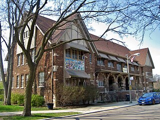
Leland Grove is a city in Sangamon County, Illinois, United States, located adjacent to Springfield. It is part of the Springfield Metropolitan Statistical Area. The population was 1,503 at the 2010 census.

Kingwood is a 14,000 acre (57 km²) master-planned community located in northeast Houston, Texas, United States. The majority of the community is located in Harris County with a small portion in Montgomery County. Known as the "Livable Forest," it is the largest master-planned community in Harris County and second-largest within the 10-county Houston-The Woodlands-Sugar Land metropolitan area. It was classified as a "census-designated place" during the 1990 census, when the population recorded was 37,397. It is on the east fork of the San Jacinto River.
Albany Park is one of 77 well-defined community areas of Chicago. Located on the Northwest Side of the City of Chicago with the North Branch of the Chicago River forming its east and north boundaries, it includes the ethnically diverse Albany Park neighborhood, with one of the highest percentages of foreign-born residents of any Chicago neighborhood.
A county island is a small or large portion of an unincorporated area that is within the jurisdiction of a county, usually surrounded by adjacent areas that are incorporated into a municipality. On maps, these geopolitical anomalies will form jagged or complex borders and 'holes' in the city limits. Generally found more frequently in the western United States, county islands form in areas of expansion when previously smaller cities will annex and incorporate more land into their jurisdiction. If residents or landowners in a particular unincorporated area do not vote to incorporate with the surrounding city, the area remains unincorporated. The formation of a county island usually follows stages where it will come into being on the edge of an incorporated area, and as more territory is incorporated, be cut off from the rest of the unincorporated area within the county. These areas are not actually exclaves by definition, because they are simply unincorporated outside of a surrounding city.
Raymond Poe is an American politician and former Republican member of the Illinois House of Representatives.

Lake Springfield is a 3,965-acre (16.05 km2) reservoir on the southeast edge of the city of Springfield, Illinois. It is 560 ft (170 m) above sea level. The lake was formed by building Spaulding Dam across Sugar Creek, a tributary of the Sangamon River. The lake and the lands adjoining it are all owned by City Water, Light & Power, the municipal utility for the city of Springfield. It is the largest municipally-owned body of water in Illinois.
Brentwood-Darlington is a neighborhood on the southern edge of Portland, Oregon, bordering SE 45th Avenue to the west, SE Duke Street to the north, and SE 82nd Avenue to the east. The county line separating Multnomah County from Clackamas County forms most of the neighborhood's southern boundary, though small portions of the neighborhood and the city extend into Clackamas County. Roughly, the southern boundary is SE Harney Drive on the eastern one-fourth, and SE Clatsop Street on the other three-quarters.

The Sangamon Mass Transit District (SMTD) is a regional mass transit district that mostly serves Springfield, Illinois along with a few neighboring communities. It is governed by a seven-member board of trustees, who are all appointed by the Sangamon County Board of Supervisors. In 2022, the system had a ridership of 1,124,800, or about 4,700 per weekday as of the fourth quarter of 2022.

Springfield Memorial Hospital (SMH) is a 500-bed non-profit teaching hospital located in Springfield, Illinois. Founded in 1897, Springfield Memorial Hospital is one of two hospitals in the Springfield metropolitan area. It also is home to the Memorial Center for Learning and Innovation, a 72,000-square-foot educational learning center. MMC is accredited by The Joint Commission and is recognized as a Magnet hospital. In 2016, the hospital was the first within Illinois to be awarded the AHA-McKesson Quest for Quality for leadership and innovation in quality improvement and safety in patient care by the American Hospital Association.
The neighborhoods of Omaha are a diverse collection of community areas and specific enclaves. They are spread throughout the Omaha metro area, and are all on the Nebraska side of the Missouri River.
James D. Henry was a militia officer from the U.S. state of Illinois who rose to the rank of general during the Black Hawk War. Henry was born in Pennsylvania in 1797, and moved to Edwardsville, Illinois in 1822. In 1825, while living in Edwardsville, he was indicted with two other men for the murder of an acquaintance, though he never went to trial. One defendant was tried but found not guilty, and following the trial Henry moved to Springfield, Illinois, where he was elected sheriff. When the Winnebago War broke out in 1827 Henry acted as adjutant for four companies of volunteers.

Medfield is a neighborhood located in north Baltimore, Maryland, United States of America. It is located to the north of the trendy Hampden neighborhood and south of affluent Roland Park neighborhood. Its unofficial boundaries are Coldspring Lane to the north; Jones Falls Expressway to the west; Falls Road/Hickory Avenue to the east; and West 41st Street to the south.
Gwenn Klingler is a former Republican member of the Illinois House of Representatives representing the 100th district from 1995 until 2003.
J. Michael "Mike" Houston is a former mayor of Springfield, Illinois. He served as Springfield's mayor from 1979 to 1987 and from 2011 to 2015.
Jim Langfelder is the former mayor of Springfield, Illinois, the state capital and seat of Sangamon County. Prior to his election to Mayor of Springfield, he served as the city treasurer for three terms spanning from 2003 to 2015. Municipal offices in Illinois are legally nonpartisan, however, Langfelder is a member of the Democratic Party.
Glenn V. Dawson is an American politician who served as a Democratic member of the Illinois House of Representatives from 1979-1980 and the Illinois Senate from 1980-1987.
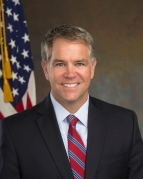
John C. Milhiser is an American attorney who served as the United States Attorney for the United States District Court for the Central District of Illinois from 2018 to 2021. Prior to becoming a U.S. Attorney, Milhiser was the Sangamon County State's Attorney. In January 2022, Milhiser announced he would seek the Republican nomination for Illinois Secretary of State in the 2022 election.


