
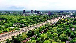
Springfield is the capital of the U.S. state of Illinois and the county seat of and most populous city in Sangamon County. The city's population was 114,394 at the 2020 census, which makes it the state's seventh most-populous city, the second largest outside of the Chicago metropolitan area, and the largest in central Illinois. Approximately 208,000 residents live in the Springfield metropolitan area.
Oakland County is a county in the U.S. state of Michigan. It is a principal county of the Detroit metropolitan area, containing the bulk of Detroit's northern suburbs. The county seat is Pontiac. As of the 2020 Census, its population was 1,274,395, making it the second-most populous county in Michigan, and the largest county in the United States without a city of 100,000 residents.

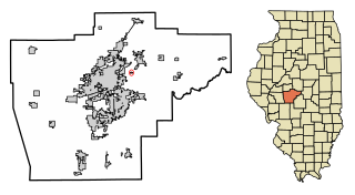
Sangamon County is located in the center of the U.S. state of Illinois. According to the 2020 census, it had a population of 196,343. Its county seat and largest city is Springfield, the state capital.
Clear Lake is an unincorporated community and former incorporated village in Sangamon County, Illinois, United States. The population was 267 at the 2000 census. It is part of the Springfield, Illinois Metropolitan Statistical Area.
Illinois Route 22, also known as Half Day Road for part of its length, is an east–west state highway in northeastern Illinois. It runs from U.S. Route 14 in Fox River Grove to U.S. Route 41 in Highland Park. It travels a distance of 19.7 miles (31.7 km) and is one of the few roads that runs almost entirely across southern Lake County while also providing access to southeastern McHenry County. Throughout its length, it shifts between two and four lanes as it passes through a frequently changing setting of scenic forestry and smaller populations, as well as busy intersections and larger developments.

Illinois Route 4 is a major north–south highway that runs south from the Interstate 55 business loop around the state capital of Springfield, south to Illinois Route 13 just north of Murphysboro. This is a distance of 170.44 miles (274.30 km).
Glenwood High School is a public high school in Chatham, Illinois, United States. It is the only high school in Ball Chatham Community Unit School District 5, which is in southern Sangamon County and includes Chatham, Glenarm, and the southern portion of Springfield, Illinois.

Lake Springfield is a 3,965-acre (16.05 km2) reservoir on the southeast edge of the city of Springfield, Illinois. It is 560 ft (170 m) above sea level. The lake was formed by building Spaulding Dam across Sugar Creek, a tributary of the Sangamon River. It is the largest municipally-owned body of water in Illinois. The lake and the lands adjoining it are all owned by City Water, Light & Power, the municipal utility for the city of Springfield, which operates the Dallman Power Plant at the lake's north end.

The Sangamon Mass Transit District (SMTD) is a regional mass transit district that mostly serves Springfield, Illinois along with a few neighboring communities. It is governed by a seven-member board of trustees, who are all appointed by the Sangamon County Board of Supervisors. In 2022, the system had a ridership of 1,124,800, or about 4,800 per weekday as of the first quarter of 2023.
The Lost Bridge Trail is a 5.0-mile (8.0 km) rail trail in Sangamon County, Illinois. It was built by the Illinois Department of Transportation (IDOT) along an abandoned Baltimore and Ohio Railroad corridor between the east side of Springfield, Illinois to the center of Rochester, Illinois.
The 15th congressional district of Illinois is currently located in central Illinois. It was located in eastern and southeastern Illinois until 2022. It is currently represented by Republican Mary Miller.

Rochester is a village and suburb of Springfield in Sangamon County, Illinois, United States. The population was 3,689 at the 2010 census, and 3,713 at a 2018 estimate. The village was settled in 1819, and is located in Rochester Township.

Central Illinois is a region of the U.S. state of Illinois that consists of the entire central third of the state, divided from north to south. Also known as the Heart of Illinois, it is characterized by small towns and mid-sized cities. Agriculture, particularly corn and soybeans, as well as educational institutions and manufacturing centers, figure prominently.

Ball Township is located in Sangamon County, Illinois. As of the 2010 census, its population was 6,701 and it contained 2,403 housing units. The township's offices are located in Glenarm. Portions of the village of Chatham are located in this township. Portions of Lake Springfield are also located in the township, including the former site of the flooded town of Cotton Hill.

Cotton Hill Township is located in Sangamon County, Illinois. As of the 2010 census, its population was 902 and it contained 389 housing units. The township is the home of Hunter Lake, a proposed 3,010-acre (12.2 km2) reservoir.
Makinen is an unincorporated community in St. Louis County, Minnesota, United States.
The Interurban Trail is a 4.75-mile (7.6 km) rail trail in Sangamon County, Illinois, United States. It was built by the Illinois Department of Transportation (IDOT) and occupies an abandoned Illinois Terminal Railroad interurban corridor. It stretches from the south side of Springfield, to the center of Chatham.
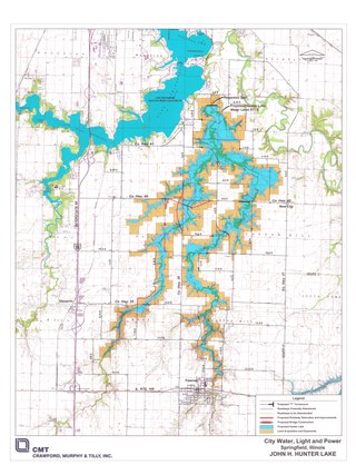
Hunter Lake is a proposed 3,070-acre (12.4 km2) reservoir to be created in Illinois, United States, by damming Horse Creek, a tributary of the Sangamon River. If the lake is built, its construction would flood a section of bottomland in southeastern Sangamon County, Illinois near the city of Springfield to an elevation of 571 feet above sea level. The lake is a project of City Water, Light & Power, the local municipal electric utility.

Interstate business routes are roads connecting a central or commercial district of a city or town with an Interstate bypass. These roads typically follow along local streets often along a former U.S. Route or state highway that had been replaced by an Interstate. Interstate business route reassurance markers are signed as either loops or spurs using a green shield shaped sign and numbered like the shield of the parent Interstate highway.

Cotton Hill, also known as Crow's Mill or Cotton Hill Post Office, was a small unincorporated community on the banks of Sugar Creek in Ball Township, Sangamon County, Illinois, about eight miles south of downtown Springfield. It stood for slightly over a century, from the 1820s until it was razed in the 1930s to make way for Lake Springfield. In 1900 the community had an estimated population of 150, a post office and a train station on the Illinois Central. Just before its demolition in the 1930s the community had a store, a schoolhouse, a blacksmith's shop, and a gas station on Route 66.


