
Stevenage is a town and borough in Hertfordshire, England, about 27 miles (43 km) north of London. Stevenage is east of junctions 7 and 8 of the A1(M), between Letchworth Garden City to the north and Welwyn Garden City to the south. In 1946, Stevenage was designated the United Kingdom's first New Town under the New Towns Act.

East Hertfordshire is one of ten local government districts in Hertfordshire, England. Its council is based in Hertford, the county town of Hertfordshire. The largest town in the district is Bishop's Stortford, and the other main towns are Ware, Buntingford and Sawbridgeworth. At the 2011 Census, the population of the district was 137,687. By area it is the largest of the ten local government districts in Hertfordshire. The district borders North Hertfordshire, Stevenage, Welwyn Hatfield and Broxbourne in Hertfordshire, and Epping Forest, Harlow and Uttlesford in Essex.

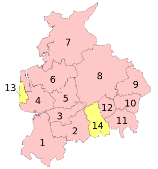
North Hertfordshire is one of ten local government districts in the county of Hertfordshire, England. Its council is based in Letchworth Garden City and the largest town is Hitchin. The district also includes the towns of Baldock and Royston and numerous villages and surrounding rural areas. Part of the district lies within the Chiltern Hills, a designated Area of Outstanding Natural Beauty.

Knebworth is a village and civil parish in the north of Hertfordshire, England, immediately south of Stevenage. The civil parish covers an area between the villages of Datchworth, Woolmer Green, Codicote, Kimpton, Whitwell, St Paul's Walden and Langley, and encompasses the village of Knebworth, the small village of Old Knebworth and Knebworth House.

A civil parish in England is the lowest unit of local government. There are 284 civil parishes in the ceremonial county of Cumbria, with most of the county being parished. At the 2001 census, there were 359,692 people living in those 284 parishes, accounting for 73.8 per cent of the county's population.

A civil parish is a country subdivision, forming the lowest unit of local government in England. There are 264 civil parishes in the ceremonial county of Cambridgeshire, most of the county being parished; Cambridge is completely unparished; Fenland, East Cambridgeshire, South Cambridgeshire and Huntingdonshire are entirely parished. At the 2001 census, there were 497,820 people living in the parishes, accounting for 70.2 per cent of the county's population.
A civil parish is a subnational entity, forming the lowest unit of local government in England. There are 219 civil parishes in the ceremonial county of Lancashire; Blackpool is completely unparished; Pendle and Ribble Valley are entirely parished. At the 2001 census, there were 587,074 people living in the 219 parishes, accounting for 41.5 per cent of the county's population.

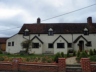
Graveley is a village and civil parish about four miles east of Hitchin and two miles north of Stevenage in Hertfordshire, England. The population of the parish in the 2011 census was 487. A milestone in the village states that it is 33 miles from London.
Shephall is a neighbourhood of the new town of Stevenage in Hertfordshire. It was formerly a separate village and parish, being absorbed into Stevenage in 1953.
In England, an unparished area is an area that is not covered by a civil parish. Most urbanised districts of England are either entirely or partly unparished. Many towns and some cities in otherwise rural districts are also unparished areas and therefore no longer have a town council or city council, and are instead directly managed by a higher local authority such as a district or county council.

Barnham is a village, Anglican parish and former civil parish, now in the civil parish of Barnham and Eastergate, in the Arun district of West Sussex, England, centred about 5 miles (8.0 km) north of Bognor Regis. On 1 April 2019 the parish was merged with Eastergate to form "Barnham and Eastergate". In 2011 the parish had a population of 1391.

Eastergate is a village, ecclesiastical parish and former civil parish, now in the parish of Barnham and Eastergate, in the Arun district of West Sussex, England. It is located five miles (8 km) east of Chichester. In 2011 the parish had a population of 3417.
Stanthorne is a village and former civil parish, now in the parish of Stanthorne and Wimboldsley, in the Cheshire West and Chester district, in the ceremonial county of Cheshire, England, 2 miles west of Middlewich. The A54 runs through the village, connecting it to the railway station at Winsford. At the 2011 census, it had a population of 153.
Brickendon is a village in the civil parish of Brickendon Liberty in the district of East Hertfordshire about 3 miles (4.8 km) south of the county town Hertford, and is served by Bayford railway station.

Ingol is an electoral ward and suburb of Preston, Lancashire, England. The population of the Ward as taken at the 2011 census was 7,369. The ward also includes the district of Tanterton. The ward is coterminous with the civil parish of Ingol and Tanterton, created in 2012.
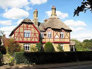
Langley is a hamlet and civil parish in the non-metropolitan district of North Hertfordshire and county of Hertfordshire. The population was 175 in the 2011 census. It is located four miles south of Hitchin, on the B656 road near the large town of Stevenage. Minsden Chapel lies within the parish.
Somerleyton, Ashby and Herringfleet is a civil parish in the north of the English county of Suffolk. It is 5 miles (8.0 km) north-west of Lowestoft and the same distance south-west of Great Yarmouth and is in the East Suffolk district. The parish is made up of the villages of Somerleyton, Ashby and Herringfleet and at the 2011 United Kingdom census had a population of 427.

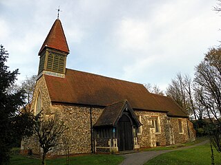
St Nicholas' Church is an Anglican parish church in Stevenage, a town in Hertfordshire, England.

