
Hitchin is a market town and unparished area in the North Hertfordshire district in Hertfordshire, England, with an estimated population of 35,842.

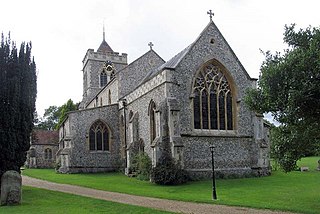
Preston is a village and civil parish about 3 miles (4.8 km) south of Hitchin in Hertfordshire, England. At the 2011 Census the population was 420.

Wing, known in antiquated times as Wyng, is a village and civil parish in east Buckinghamshire, England. The village is on the main A418 road between Aylesbury and Leighton Buzzard. It is about 8 miles (13 km) north-east of Aylesbury, 3 miles (5 km) west of Leighton Buzzard, and 12 miles (19 km) south of Milton Keynes.

Baldock is a historic market town and unparished area in the local government district of North Hertfordshire in the county of Hertfordshire, England, where the River Ivel rises. It lies 33 miles (53 km) north of London, 15 miles (24 km) southeast of Bedford, and 14 miles (23 km) north northwest of the county town of Hertford. Nearby towns include Royston to the northeast, Letchworth and Hitchin to the southwest and Stevenage to the south.
Willian is a village and former civil parish, now in the unparished area of Letchworth, in the North Hertfordshire district, in the county of Hertfordshire, England. Along with Norton and Old Letchworth, it is one of the original three villages around which the garden city of Letchworth Garden City was created. Despite this, the village retains a separate character to the rest of Letchworth Garden City. In 1931 the parish had a population of 210.

Ickleford is a large village situated on the northern outskirts of Hitchin in North Hertfordshire in England. It lies on the west bank of the River Hiz and to the east of the main A600 road. The population at the time of the 2011 census was 1,833.
Therfield is both a small village of approximately 4,761 acres (19 km²) and a civil parish which sits upon the chalk range, three miles southwest of Royston, and six miles (10 km) northeast of Baldock and within the English county of Hertfordshire.

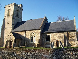
St Ippolyts is a village and civil parish on the southern edge of Hitchin in Hertfordshire, England. It has a population of approximately 2,000.

Kimpton is a village in Hertfordshire, England, six miles south of Hitchin, seven miles north of St Albans and four miles from Harpenden and Luton. The population at the 2011 Census was 2,167.
Lilley is a small village and civil parish situated between Hitchin and Luton in Hertfordshire, England. Lilley stands on high ground: nearby Telegraph Hill is just over 600 feet above sea level.
Hexton is a small village and civil parish in Hertfordshire, England, about 6 miles (10 km) west of Hitchin.

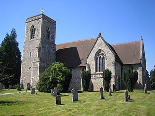
Graveley is a village and civil parish about four miles east of Hitchin and two miles north of Stevenage in Hertfordshire, England. The population of the parish in the 2011 census was 487. A milestone in the village states that it is 33 miles from London.

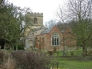
Great Wymondley is a village and former civil parish situated near Hitchin, now in the parish of Wymondley, in the North Hertfordshire district, in the county of Hertfordshire, England. Despite the names, Great Wymondley is a smaller settlement than its neighbour, Little Wymondley. In 1931 the parish had a population of 285.

Aldenham is a village and civil parish in Hertfordshire, 3.5 miles (5.6 km) north-east of Watford and 2 miles (3.2 km) southwest of Radlett. It was mentioned in the Domesday Book and is one of Hertsmere's 14 conservation areas. The village has eight pre-19th-century listed buildings and the parish itself is largely unchanged, though buildings have been rebuilt, since Saxon times when the majority of the land was owned by the abbots of Westminster Abbey.

Shillington is a village and civil parish in Bedfordshire, England. In the south of the parish the hamlet of Pegsdon includes the Pegsdon hills nature reserve and is a salient of the county into Hertfordshire. Since 1985 its administration has included the village of Higham Gobion, south-west on the minor road leading to the main north–south road in the district, the A6. It has a population of 1,831 and is centred midway between stopping services railway stations on the Midland Main Line and East Coast Main Line 6 miles (9.7 km) away. Farmland and hedgerows forms 95% of the land use and to the south and north of the boundaries is intermittent woodland.

Barkway is a long-established village and civil parish in the North Hertfordshire district of Hertfordshire, England, about five miles south-east of Royston, 35 miles from London and 15 miles from the centre of Cambridge. The Prime Meridian passes a mile or so to the west of Barkway.

Barley is a village and civil parish in the district of North Hertfordshire, England. According to the 2001 census, it has a population of 659, increasing to 662 at the 2011 Census. The place-name refers to a lea or meadow and not to the grain-producing plant. Coincidentally to the southwest lies the village of Reed. The Prime Meridian passes to the west of Barley, which is located on the Royston to Saffron Walden road, as well as the medieval London to Cambridge road.

Kelshall is a small village in North East Hertfordshire, England. It is near the town of Royston. It has a village hall and the local church is St Faith's. Kelshall is also the name of the civil parish. Kelshall also has a major road running along one of its boundaries. In the 1880s the church was described as being "ancient, plain, and good, with a tower; and contains a few brasses and monuments".

Steeple Morden is a village and civil parish in Cambridgeshire, England, about 15 miles (24 km) south west of Cambridge and 5 miles (8 km) west of Royston. It is part of the South Cambridgeshire local government district.

Wallington is a small village and civil parish in the North Hertfordshire district, in the county of Hertfordshire, England, near the town of Baldock. The population of the civil parish at the 2011 Census was 150. Nearby villages include Rushden and Sandon. It shares a parish council with Rushden.

