Guernsey, Iowa

Last updated

Guernsey, Iowa
Poweshiek County Iowa Incorporated and Unincorporated areas Guernsey Highlighted.svg
Location of Guernsey, Iowa
Coordinates: 41°39′0″N92°20′40″W / 41.65000°N 92.34444°W / 41.65000; -92.34444
Country Flag of the United States.svg  United States
State Flag of Iowa.svg  Iowa
County Poweshiek
Area
[1]
  Total0.56 sq mi (1.46 km2)
  Land0.56 sq mi (1.46 km2)
  Water0.00 sq mi (0.00 km2)
Elevation
823 ft (251 m)
Population
 (2020)
  Total63
  Density112.10/sq mi (43.25/km2)
Time zone UTC-6 (Central (CST))
  Summer (DST) UTC-5 (CDT)
ZIP code
52221
Area code 319
FIPS code 19-33285
GNIS feature ID0457176

Guernsey is a town in Poweshiek County, Iowa, United States. The population was 63 at the time of the 2020 census. [2]

Contents

History

Guernsey was platted in 1884. [3] It was named after Guernsey County, Ohio. [3] A post office was first established in Guernsey in 1884. [4]

Geography

Guernsey is located at 41°39′0″N92°20′40″W / 41.65000°N 92.34444°W / 41.65000; -92.34444 (41.650087, -92.344498). [5]

According to the United States Census Bureau, the town has a total area of 0.18 square miles (0.47 km2), all land. [6]

Demographics

Historical populations
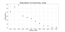
YearPop.±%
1910 143    
1920 167+16.8%
1930 177+6.0%
1940 121−31.6%
1950 113−6.6%
1960 108−4.4%
1970 94−13.0%
1980 83−11.7%
1990 70−15.7%
2000 70+0.0%
2010 63−10.0%
2020 63+0.0%
Source: "U.S. Census website". United States Census Bureau . Retrieved March 29, 2020. and Iowa Data Center
Source:
U.S. Decennial Census [7] [2]
The population of Guernsey, Iowa from US census data GuernseyIowaPopPlot.png
The population of Guernsey, Iowa from US census data

2010 census

As of the census [8] of 2010, there were 63 people, 27 households, and 18 families living in the town. The population density was 350.0 inhabitants per square mile (135.1/km2). There were 32 housing units at an average density of 177.8 per square mile (68.6/km2). The racial makeup of the city was 96.8% White. Hispanic or Latino of any race were 3.2% of the population.

There were 27 households, of which 22.2% had children under the age of 18 living with them, 55.6% were married couples living together, 11.1% had a female householder with no husband present, and 33.3% were non-families. 25.9% of all households were made up of individuals, and 11.1% had someone living alone who was 65 years of age or older. The average household size was 2.33 and the average family size was 2.83.

The median age in the town was 43.8 years. 23.8% of residents were under the age of 18; 6.3% were between the ages of 18 and 24; 22.2% were from 25 to 44; 19.1% were from 45 to 64; and 28.6% were 65 years of age or older. The gender makeup of the town was 52.4% male and 47.6% female.

2000 census

As of the census [9] of 2000, there were 70 people, 29 households, and 20 families living in the town. The population density was 379.8 inhabitants per square mile (146.6/km2). There were 34 housing units at an average density of 184.5 per square mile (71.2/km2). The racial makeup of the city was 94.29% White, 1.43% Native American, 2.86% from other races, and 1.43% from two or more races. Hispanic or Latino of any race were 4.29% of the population.

There were 29 households, out of which 34.5% had children under the age of 18 living with them, 62.1% were married couples living together, 3.4% had a female householder with no husband present, and 31.0% were non-families. 31.0% of all households were made up of individuals, and 6.9% had someone living alone who was 65 years of age or older. The average household size was 2.41 and the average family size was 3.05.

In the town, the population was spread out, with 28.6% under the age of 18, 5.7% from 18 to 24, 24.3% from 25 to 44, 32.9% from 45 to 64, and 8.6% who were 65 years of age or older. The median age was 35 years. For every 100 females, there were 118.8 males. For every 100 females age 18 and over, there were 127.3 males.

The median income for a household in the city was $36,250, and the median income for a family was $46,250. Males had a median income of $26,250 versus $16,458 for females. The per capita income for the city was $17,727. None of the population and none of the families were below the poverty line.

Education

The BGM Community School District operates the local area public schools. [10] BGM Community School District was formed in 1960 with the merger of schools in Brooklyn, Guernsey, and Malcom.

Related Research Articles

<span class="mw-page-title-main">Poweshiek County, Iowa</span> County in Iowa, United States

Poweshiek County is a county in the southeastern part of the U.S. state of Iowa. As of the 2020 census, the population was 18,662. The county seat is Montezuma. The county is named for the chief of the Fox tribe who signed the treaty ending the Black Hawk War. It lies along Interstate 80 between Des Moines and Iowa City. Poweshiek County's largest city is Grinnell.

<span class="mw-page-title-main">Jasper County, Iowa</span> County in Iowa, United States

Jasper County is a county in the U.S. state of Iowa. As of the 2020 census, the population was 37,813. The county seat is Newton. The county was organized in 1846 and is named after Sergeant William Jasper, a Revolutionary War hero.
<span class="mw-page-title-main">Rapids City, Illinois</span> Village in Illinois, United States

Rapids City is a village in Rock Island County, Illinois, United States. The population was 959 at the 2010 census, up from 953 in 2000.

<span class="mw-page-title-main">Stinesville, Indiana</span> Town in Indiana, United States

Stinesville is a town in Bean Blossom Township, Monroe County, in the U.S. state of Indiana. The population was 203 at the 2020 census. It is part of the Bloomington Metropolitan Statistical Area.

<span class="mw-page-title-main">Brooklyn, Iowa</span> City in Iowa, United States

Brooklyn is a city in Poweshiek County, Iowa, United States. The population was 1,502 at the 2020 census. It is located just off U.S. Route 6 and a few miles north of Interstate 80. Near the center of town, Brooklyn boasts a large display of flags from each of the fifty states, branches of the military, and a smattering of other sources. The city bills itself as "Brooklyn: Community of Flags."

<span class="mw-page-title-main">Malcom, Iowa</span> City in Iowa, United States

Malcom is a city in Poweshiek County, Iowa, United States. The population was 270 at the time of the 2020 census. The city was named for an early settler. The town's major businesses include BASF, a restaurant, and Dayton Meat Products.

<span class="mw-page-title-main">Montezuma, Iowa</span> City in Iowa, United States

Montezuma is a city in Poweshiek County, Iowa, United States. The population was 1,442 at the time of the 2020 census. It is the county seat of Poweshiek County.

<span class="mw-page-title-main">Searsboro, Iowa</span> Unincorporated community in Iowa, United States

Searsboro in an unincorporated community in Poweshiek County, Iowa, United States. The population was 148 at the 2010 census. The city attempted to disincorporate in 2011, but the move failed when Poweshiek County refused to take control of the city's infrastructure.

<span class="mw-page-title-main">Sun, Louisiana</span> Village in Louisiana, United States

Sun is a village in the northeastern corner of St. Tammany Parish, Louisiana, United States. The population was 470 at the 2010 census. It is part of the New Orleans–Metairie–Kenner Metropolitan Statistical Area.

<span class="mw-page-title-main">Amanda, Ohio</span> Village in Ohio, United States

Amanda is a village in Fairfield County, Ohio, United States. The population was 637 at the 2020 census.
<span class="mw-page-title-main">Cumberland, Ohio</span> Village in Guernsey County, Ohio, United States

Cumberland is a village in Guernsey County, Ohio, United States. It is seventy miles east of Columbus. The population was 317 at the 2020 census.

<span class="mw-page-title-main">Lore City, Ohio</span> Village in Ohio, United States

Lore City is a village in Guernsey County, Ohio, United States. The population was 282 at the 2020 census.

<span class="mw-page-title-main">Old Washington, Ohio</span> Village in Ohio, United States

Old Washington is a village in Guernsey County, Ohio, United States. The population was 223 at the 2020 census.

<span class="mw-page-title-main">Pleasant City, Ohio</span> Village in Ohio, United States

Pleasant City is a village in Guernsey County, Ohio, United States. The population was 400 at the 2020 census.

<span class="mw-page-title-main">Pine Township, Crawford County, Pennsylvania</span> Township in Pennsylvania, United States

Pine Township is a township in Crawford County, Pennsylvania, United States. The population was 432 at the 2020 census, down from 462 at the 2010 census.

<span class="mw-page-title-main">Troy Township, Crawford County, Pennsylvania</span> Township in Pennsylvania, United States

Troy Township is a township in Crawford County, Pennsylvania, United States. The population was 1,053 at the 2020 census, down from 1,235 at the 2010 census.

<span class="mw-page-title-main">Hamilton Township, Tioga County, Pennsylvania</span> Township in Pennsylvania, United States

Hamilton Township is a township in Tioga County, Pennsylvania, United States. The population was 534 at the 2020 census.

<span class="mw-page-title-main">Coalmont, Tennessee</span> City in Tennessee, United States

Coalmont is a city in Grundy County, Tennessee, United States. Established in 1904, the city has an area of 6 square miles. The population was 841 at the 2010 census.

<span class="mw-page-title-main">Granger, Washington</span> City in Washington, United States

Granger is a city in Yakima County, Washington, United States. The population was 3,624 at the 2020 census. Although it was classified as a town in 2000, it has since been reclassified as a city.

<span class="mw-page-title-main">Fairview, Ohio</span> Village in Ohio, United States

Fairview is a village in Belmont and Guernsey counties in the U.S. state of Ohio. The population was 67 as of the 2020 census. It is part of the Wheeling metropolitan area.

References

  1. "2020 U.S. Gazetteer Files". United States Census Bureau. Retrieved March 16, 2022.
  2. 1 2 "2020 Census State Redistricting Data". census.gov. United states Census Bureau. Retrieved August 12, 2021.
  3. 1 2 Chicago and North Western Railway Company (1908). A History of the Origin of the Place Names Connected with the Chicago & North Western and Chicago, St. Paul, Minneapolis & Omaha Railways. p. 81.
  4. "Poweshiek County". Jim Forte Postal History. Retrieved March 16, 2015.
  5. "US Gazetteer files: 2010, 2000, and 1990". United States Census Bureau. February 12, 2011. Retrieved April 23, 2011.
  6. "US Gazetteer files 2010". United States Census Bureau . Retrieved May 11, 2012.
  7. "Census of Population and Housing". Census.gov. Retrieved June 4, 2015.
  8. "U.S. Census website". United States Census Bureau . Retrieved May 11, 2012.
  9. "U.S. Census website". United States Census Bureau . Retrieved January 31, 2008.
  10. "FY20_BROOKLYN-GUERNSEY-MALCOM" (PDF). Iowa Department of Education. Retrieved July 6, 2020.