Deep River, Iowa

Last updated

Deep River, Iowa
Poweshiek County Iowa Incorporated and Unincorporated areas Deep River Highlighted.svg
Location of Deep River, Iowa
Coordinates: 41°34′49″N92°22′27″W / 41.58028°N 92.37417°W / 41.58028; -92.37417
Country Flag of the United States.svg  United States
State Flag of Iowa.svg  Iowa
County Poweshiek
Government
  MayorDerec Koch
   Iowa House Dean Fisher (R)
   Iowa Senate Annette Sweeney (R)
   U.S. Congress Ashley Hinson (R)
Area
[1]
  Total0.44 sq mi (1.13 km2)
  Land0.44 sq mi (1.13 km2)
  Water0.00 sq mi (0.00 km2)
Elevation
909 ft (277 m)
Population
 (2020)
  Total249
  Density569.79/sq mi (219.79/km2)
Time zone UTC-6 (Central (CST))
  Summer (DST) UTC-5 (CDT)
ZIP code
52222
Area code 641
FIPS code 19-19495
GNIS feature ID0455847

Deep River is a city in Poweshiek County, Iowa, United States. It is also the name of the township which includes the city. The city population was 249 at the time of the 2020 census. [2]

Contents

Geography

Deep River is located at 41°34′49″N92°22′27″W / 41.58028°N 92.37417°W / 41.58028; -92.37417 (41.580395, -92.374249). [3] According to the United States Census Bureau, the city has a total area of 0.43 square miles (1.11 km2), all land. [4]

Brief history and etymology

In 1856 the town of Dresden, approximately one mile east of the present town of Deep River, was platted. The Whitney brothers operated a store there for about 20 years. When the Chicago and North Western Railway was built, the residents of Dresden moved to be near the railroad, and thus the town of Deep River was established in 1884. The Dresden Cemetery lies about a mile and a half south of the current county road, locally known as the Diamond Trail, just about a quarter mile east of Iowa Highway 21. The town of Tilton was established at the southern border of the township in 1884 as well, although this largely lay in Keokuk County.

Deep River Township

Deep River Township was organized March 7, 1857. It was, at first, a part of Jackson Township. It derived its name from the stream [5] flowing through its northern part, but not because the water was so deep, but rather it was so far down to the water. The first settlers to live in Deep River Township were Robert Taylor and family from Ohio; John Sargood, whose father was from England; Albert Morgan and family from Ohio; and the Lights, who came from Virginia in 1849. The first post office was established in 1852, and called Deep River. The first marriage was that of Nancy Taylor to Rev. W. H. Palmer in 1849. James Light and James Rundle settled in that same year.

The first township election was held in 1857 with the following officers: Ephraim Cox, Asa Cohoe and John Morgan, trustees; Myron Whitney, clerk; L. Mayo, C. M. Wolcott, justices of the peace; H. Armstrong and C. Barber, constables; and James Hillman, road supervisor.

Town of Deep River

The town of Deep River was incorporated in the summer of 1887 after the Northwestern Railroad spur from Belle Plaine to Muchakinock in southern Iowa was built. Horace Phelps built a depot and gave the railroad $1,500 to secure the location there. The citizens of Dresden then soon followed and the new town of Deep River grew, leaving Dresden largely uninhabited. The first town election resulted in the following officers: J. S. Potter, Mayor; S. S. Jenkins, recorder; J. C. Sanders, treasurer; C. F. Cutler, assessor; James Sargood, marshal; A. C. Converse, Charles Lacher, N. M. Valentine, J. P. Sargood, E. T. Whitney and James Light, councilmen.

The Deep River flows nearby; it is a minor tributary of the English River. The town and its namesake river were named not for the depth of the water in the Deep River, but for the depth of the ravine through which it flows. At some places the banks are 20 ft (6.1 m) above the normal water level.

On May 14, 1970, the local area was subjected to a significant flood on the Deep River which was assessed as having a greater than 50 year recurrence interval. [6] The stream gauge on the Deep River station measured a record stage of 83.85 feet (25.56 m) and with a stream flow of 6,200 cubic feet per second (180 m3/s) [7]

Demographics

Historical populations
YearPop.±%
1890 291    
1900 403+38.5%
1910 467+15.9%
1920 487+4.3%
1930 392−19.5%
1940 443+13.0%
1950 379−14.4%
1960 329−13.2%
1970 323−1.8%
1980 323+0.0%
1990 345+6.8%
2000 288−16.5%
2010 279−3.1%
2020 249−10.8%
Source: "U.S. Census website". United States Census Bureau . Retrieved March 29, 2020. and Iowa Data Center
Source:
U.S. Decennial Census [8] [2]
The population of Deep River, Iowa from US census data Deep RiverIowaPopPlot.png
The population of Deep River, Iowa from US census data

2010 census

As of the census [9] of 2010, there were 279 people, 119 households, and 75 families residing in the city. The population density was 648.8 inhabitants per square mile (250.5/km2). There were 130 housing units at an average density of 302.3 per square mile (116.7/km2). The racial makeup of the city was 100.0% White.

There were 119 households, of which 31.9% had children under the age of 18 living with them, 47.9% were married couples living together, 6.7% had a female householder with no husband present, 8.4% had a male householder with no wife present, and 37.0% were non-families. 30.3% of all households were made up of individuals, and 18.5% had someone living alone who was 65 years of age or older. The average household size was 2.34 and the average family size was 2.95.

The median age in the city was 37.7 years. 24.7% of residents were under the age of 18; 6.7% were between the ages of 18 and 24; 25.9% were from 25 to 44; 24% were from 45 to 64; and 18.6% were 65 years of age or older. The gender makeup of the city was 50.5% male and 49.5% female.

2000 census

As of the census [10] of 2000, there were 288 people, 120 households, and 80 families residing in the city. The population density was 681.1 inhabitants per square mile (263.0/km2). There were 135 housing units at an average density of 319.3 per square mile (123.3/km2). The racial makeup of the city was 100.00% White. Hispanic or Latino of any race were 1.04% of the population.

There were 120 households, out of which 32.5% had children under the age of 18 living with them, 55.8% were married couples living together, 5.0% had a female householder with no husband present, and 33.3% were non-families. 28.3% of all households were made up of individuals, and 17.5% had someone living alone who was 65 years of age or older. The average household size was 2.40 and the average family size was 2.98.

Age/Gender Breakdown: 27.1% under the age of 18, 6.3% from 18 to 24, 30.2% from 25 to 44, 23.6% from 45 to 64, and 12.8% who were 65 years of age or older. The median age was 36 years. For every 100 females, there were 87.0 males. For every 100 females age 18 and over, there were 90.9 males.

The median income for a household in the city was $33,438, and the median income for a family was $46,875. Males had a median income of $29,643 versus $17,639 for females. The per capita income for the city was $16,437. About 4.9% of families and 5.6% of the population were below the poverty line, including 5.6% of those under the age of eighteen and 10.0% of those 65 or over.

Education

Deep River is mostly within the Montezuma Community School District and partially in the English Valleys Community School District. [11] [12]

The community was previously located within the Deep River–Millersburg Community School District (DR-M), [13] which was established in 1958 as a consolidation of the Deep River and Millersburg school districts. In 1992 the district closed its secondary school and began a joint whole grade-sharing program with the English Valleys district and that of the Montezuma, in which it sent its junior and senior high school students to both districts; each student chose which secondary school to attend. The Deep River grade school was closed that year, with elementary school students moved to Millersburg, as the district found the layout of the latter more useful. [14] On July 1, 2009, the DR-M district was consolidated into the English Valleys district, although a portion of it was given to the Montezuma district. [15]

Related Research Articles

<span class="mw-page-title-main">Poweshiek County, Iowa</span> County in Iowa, United States

Poweshiek County is a county in the southeastern part of the U.S. state of Iowa. As of the 2020 census, the population was 18,662. The county seat is Montezuma. The county is named for the chief of the Fox tribe who signed the treaty ending the Black Hawk War. It lies along Interstate 80 between Des Moines and Iowa City. Poweshiek County's largest city is Grinnell.

New Ross is a town in Walnut Township, Montgomery County, in the U.S. state of Indiana. As of the 2020 census, the town population was 309.

<span class="mw-page-title-main">Montezuma, Indiana</span> Town in Indiana, United States

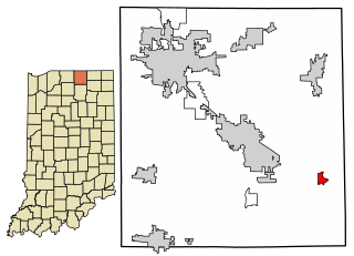
Montezuma is a town in Reserve Township, Parke County, in the U.S. state of Indiana. The population was 1,022 at the 2010 census. It is located approximately 66 miles west of the state capital Indianapolis.

<span class="mw-page-title-main">Lansing, Iowa</span> City in Iowa, United States

Lansing is a city in Lansing Township, Allamakee County, Iowa, United States. The population was 968 at the time of the 2020 census.

<span class="mw-page-title-main">Boxholm, Iowa</span> City in Iowa, United States

Boxholm is a city in Grant Township, Boone County, Iowa, United States. The population was 181 at the 2020 census. It is part of the Boone, Iowa Micropolitan Statistical Area, which is a part of the larger Ames-Boone, Iowa Combined Statistical Area.

<span class="mw-page-title-main">Sioux Rapids, Iowa</span> City in Iowa, United States

Sioux Rapids is a city in Buena Vista County, Iowa, United States. The population was 748 at the time of the 2020 census.

<span class="mw-page-title-main">Redfield, Iowa</span> City in Iowa, United States

Redfield is a city, one of two incorporated settlements in Union Township, Dallas County, Iowa, United States, along the Middle Raccoon River. The population was 731 at the time of the 2020 census. It is part of the Des Moines–West Des Moines Metropolitan Statistical Area.

<span class="mw-page-title-main">Steamboat Rock, Iowa</span> City in Iowa, United States

Steamboat Rock is a city in Hardin County, Iowa, United States. The population was 264 at the time of the 2020 census.

<span class="mw-page-title-main">Missouri Valley, Iowa</span> City in Iowa, United States

Missouri Valley is a city in Harrison County, Iowa, United States. The population was 2,678 at the time of the 2020 census.

<span class="mw-page-title-main">Wayland, Iowa</span> Village in Iowa, United States

Wayland is a village in Jefferson Township, Henry County, Iowa, United States. The population was 964 at the time of the 2020 census.

<span class="mw-page-title-main">Thor, Iowa</span> Town in Iowa, United States

Thor is a town in Norway Township, Humboldt County, Iowa, United States. The population was 181 at the time of the 2020 census.

<span class="mw-page-title-main">Millersburg, Iowa</span> City in Iowa, United States

Millersburg is a city in Iowa County, Iowa, United States. The population was 135 at the time of the 2020 census.

<span class="mw-page-title-main">Mapleton, Iowa</span> City in Iowa, United States

Mapleton is a city in Monona County, Iowa, United States. The population was 1,165 at the time of the 2020 census.

<span class="mw-page-title-main">Montezuma, Iowa</span> City in Iowa, United States

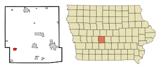
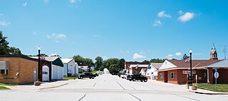
Montezuma is a city in Poweshiek County, Iowa, United States. The population was 1,442 at the time of the 2020 census. It is the county seat of Poweshiek County.

<span class="mw-page-title-main">Panama, Iowa</span> City in Iowa, United States

Panama is a city in Shelby County, Iowa, United States. The population was 235 at the time of the 2020 census.

<span class="mw-page-title-main">Westphalia, Iowa</span> City in Iowa, United States

Westphalia is a city in Shelby County, Iowa, United States. The population was 126 at the time of the 2020 census.

<span class="mw-page-title-main">Millersburg, Pennsylvania</span> Borough in Pennsylvania, United States

Millersburg is a borough in Dauphin County, Pennsylvania, United States. The population was 2,541 at the 2020 census. It is part of the Harrisburg–Carlisle Metropolitan Statistical Area.

<span class="mw-page-title-main">Barnes City, Iowa</span> City in Iowa, United States

Barnes City is a city in Mahaska and Poweshiek counties in the U.S. state of Iowa. The population was 156 at the 2020 census.

<span class="mw-page-title-main">Millersburg, Indiana</span> Town in Indiana, United States

Millersburg is a town in Clinton and Benton townships, Elkhart County, Indiana, United States. The population was 903 at the 2010 census.

<span class="mw-page-title-main">Millersburg, Ohio</span> Village in Ohio, United States

Millersburg is a village and the county seat of Holmes County, Ohio, United States. Located 66 miles (106 km) south of Cleveland, it is in the heart of Ohio's Amish Country and is part of a large regional tourism industry. The population was 3,151 at the 2020 census. Holmes County Airport, located two miles southwest of Millersburg, serves the county.

References

  1. "2020 U.S. Gazetteer Files". United States Census Bureau. Retrieved March 16, 2022.
  2. 1 2 "2020 Census State Redistricting Data". census.gov. United states Census Bureau. Retrieved August 12, 2021.
  3. "US Gazetteer files: 2010, 2000, and 1990". United States Census Bureau. February 12, 2011. Retrieved April 23, 2011.
  4. "US Gazetteer files 2010". United States Census Bureau. Archived from the original on January 25, 2012. Retrieved May 11, 2012.
  5. Gannett, Henry (1905). The Origin of Certain Place Names in the United States. Govt. Print. Off. pp.  102.
  6. U.S. Geological Survey Water-supply Paper , p. PA8, at Google Books
  7. U.S. Geological Survey Water-supply Paper , p. PA234, at Google Books
  8. "Census of Population and Housing". Census.gov. Retrieved June 4, 2015.
  9. "U.S. Census website". United States Census Bureau . Retrieved May 11, 2012.
  10. "U.S. Census website". United States Census Bureau . Retrieved January 31, 2008.
  11. "Montezuma." Iowa Department of Education. Retrieved on January 18, 2019.
  12. "English Valleys." Iowa Department of Education. Retrieved on January 18, 2019.
  13. "River-Millersburg1.pdf Deep River–Millersburg Community School District." Iowa Secretary of State. Retrieved on January 18, 2019.
  14. "History." Deep River–Millersburg Community School District. March 22, 2005. Retrieved on January 18, 2019.
  15. "REORGANIZATION & DISSOLUTION ACTIONS SINCE 1965-66 Archived 2019-02-09 at the Wayback Machine ." Iowa Department of Education. Retrieved on January 17, 2019.

Further reading