History
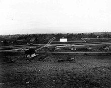
First homesteaded by M.D. Woodin in 1863, [5] Hillman City as a community originated in the 1890s, with a stop on the new Rainier Valley Electric Railway as its nucleus. The neighborhood was named after Clarence Dayton "C.D." Hillman, who platted the area and built himself a house there just off of Rainier. Hillman was a real estate developer, and his business practices ranging into the fraudulent eventually landed him in a federal penitentiary. [3] [6] [7] Hillman City resident Mikala Woodward, director of the Rainier Valley Historical Society, acknowledged at the time of the centennial of the neighborhood's annexation by Seattle, "We were named after a sleazy charlatan." [6] [8] Seattle pioneer Birdsey Wetmore resided in Hillman City until his death in 1909.
While never a serious challenger to Columbia City as the region's main business district, Hillman City did boast a real estate office, grocery, butcher, hardware store, bakery, tile factory, movie theater, and for a time an opera house and a circular fountain at the intersection of Rainier and Orcas. Like most of the Rainier Valley, Hillman City declined after the mid-20th century; in the 1980s its perhaps best-known institution was the former grocery and butcher shop, which had become Hillman City Boxing Gym (the building is, as of 2011, Lee’s Martial Arts Academy, offering instruction in karate and taekwondo). [3] In 1999, a Department of Neighborhoods study wrote that "Historic Hillman City… is commonly described by residents as deteriorating and depressed. However, with a near continuous facade of streetfront buildings and a modest pedestrian scale, Hillman City has the opportunity, many believe, to become an attractive neighborhood center." [9]
Recent history
By 2007, the neighborhood was showing some signs of recovery, though still a mixed picture. [6] The Hillman City Business Association worked to improve the quality of life in the neighborhood, by organizing community events, patrols, and litter cleanups.
In June 2013, a congregation and an arts collective leased a building on the northwest corner of Rainier and Orcas and an adjacent vacant lot, gutted the space, and, several months later, opened the Hillman City Collaboratory, a non-profit community center and co-working space. [10] The Collaboratory closed in 2021.
In August 2013, the Seattle Weekly named Hillman City the "Best Up-and-Coming Neighborhood" in Seattle. Some worry, however, that the neighborhood may lose its identity as it changes. [11]
In 2015, a group called Vision Hillman City held a series of roundtable discussions open to all neighbors and designed to identify neighborhood priorities, create plans for future action, and cultivate a shared neighborhood identity. [12]
By 2022, Hillman City continued its existence as one of Seattle's more obscure neighborhoods.
Columbia City is a neighborhood located in the southeastern part of Seattle, Washington in the Rainier Valley district. It has a landmark-protected historic business district and is one of the few Seattle neighborhoods with a long history of ethnic and income diversity.

Seward Park is a neighborhood in southeast Seattle, Washington just west of the park of the same name. It is part of Seattle's South End. The park occupies all of Bailey Peninsula.
The Burke–Gilman Trail is a rail trail in King County, Washington. The 27-mile (43 km) multi-use recreational trail is part of the King County Regional Trail System and occupies an abandoned Seattle, Lake Shore and Eastern Railway (SLS&E) corridor.

Greenwood is a neighborhood in north central Seattle, Washington, United States. The intersection of Greenwood Avenue North and North 85th Street is the commercial center. Greenwood is known for its numerous bars, restaurants, coffee houses, theatres and specialty stores. Greenwood's main thoroughfares are Greenwood Avenue North and North 80th and 85th streets.

Factoria is a mixed-use suburban neighborhood in south Bellevue, Washington and is one of the city's significant commercial districts. Originally timberland from the 1890s to 1920s and later envisioned as an industrial center, Factoria has since the 1960s evolved into commercial and residential development. Factoria was annexed into Bellevue in 1993. The core neighborhood is bounded by Interstate 90 to the north, Interstate 405 to the west, Newport Way to the east, and Coal Creek Parkway to the south.

Beacon Hill is a hill and neighborhood in southeast Seattle, Washington. It is roughly bounded on the west by Interstate 5, on the north by Interstate 90, on the east by Rainier Avenue South, Cheasty Boulevard South, and Martin Luther King Junior Way South, and on the south by the Seattle city boundary. It is part of Seattle's South End.

Georgetown is a neighborhood in Seattle, Washington, United States. It is bounded on the north by the mainlines of the BNSF Railway and Union Pacific Railroad, beyond which is the Industrial District; on the west by the Duwamish River, across which is South Park; on the east by Interstate 5, beyond which is Beacon Hill; and on the south by Boeing Field.

Mount Baker is a neighborhood in southeast Seattle. The neighborhood's name comes from the view of Mount Baker in Whatcom County, that is seen by looking north over Lake Washington. It is bounded by Lake Washington to the east, Interstate 90 and then Leschi to the north, Rainier Valley to the west, and Columbia City to the south. The neighborhood has a community club and a rowing team. It hosts Seattle's annual Seafair, which includes an airshow featuring the U.S. Navy Blue Angels, hydroplane races, a fireworks show, and other festivities. Franklin High School and Garfield High School serve this area. It is part of Seattle's South End.

The Rainier Valley is a district in southeast Seattle. It is located east of Beacon Hill; west of Mount Baker, Seward Park, and Leschi; south of the Central District and north of Rainier Beach. It is part of Seattle's South End.

Rainier Beach is a set of neighborhoods in Seattle, Washington that are mostly residential. Also called Atlantic City, Rainier Beach can include Dunlap, Pritchard Island, and Rainier View neighborhoods.
Clearview is a small unincorporated community and census-designated place (CDP) in Snohomish County, Washington, United States. The population was 3,324 at the 2010 census. Clearview is located on the west side of State Route 9, where it intersects 180th Street SE in Snohomish County, Washington, United States. It is located between Snohomish and Woodinville and the top of the Clearview Hill.
Kennydale is a neighborhood in Renton, Washington, in the United States. As of 2008, it had an estimated population of 4,840. It lies along the southeastern shore of Lake Washington and straddles Interstate 405 which runs north-south between Renton and Bellevue, and borders the Newport Shores neighborhood of Bellevue. The part of the neighborhood on the lake (west) side of I-405 is referred to as "Lower Kennydale", and on the east side "Upper Kennydale".
Brighton is a primarily residential neighborhood in south Seattle, Washington, part of the greater Rainier Valley district and centered about a mile and a half south of the Columbia City neighborhood.
Lakeridge is a hillside neighborhood near Lake Washington located mostly in unincorporated Skyway/West Hill in King County, Washington, and partially in the southeast portion of the City of Seattle's Rainier Beach neighborhood. Its boundaries extend from Seattle's Rainier Beach neighborhood on the north, to Lake Washington on the east, to unincorporated Bryn Mawr on the southeast and unincorporated Skyway on the southwest.
The South End (Soufend) is a group of neighborhoods in the southeast of Seattle, Washington, U.S.A. The definition is a bit fluid, but has traditionally included the area south of the Central District, and east of Interstate 5: Rainier Valley, Columbia City, Rainier Beach, Seward Park, Mount Baker, and Beacon Hill. Sometimes its definition is extended to Skyway and Bryn Mawr in unincorporated King County, though these are not technically in the city. Other definitions have included northern parts of Renton and Tukwila, though most Seattleites, especially those from the South End, would consider this usage incorrect. Often the term "South End" is used colloquially to include neighboring portions of South King County, by people living in those areas, due to that area's location in reference to Seattle proper.

Genesee Park is a 57.7-acre (0.234 km2) park in the Rainier Valley neighborhood of Seattle, Washington. A waterway, Wetmore Slough, before the lowering of Lake Washington by nine feet in 1917 as part of the construction of the Lake Washington Ship Canal, it was purchased by the city in 1947 and used as a dump until 1963. Development of the park began in 1968. It hosts the hydroplane races and aerobatics air show during the annual Seattle Seafair, in July–August.

Othello station is a light rail station located in Seattle, Washington. It is situated between the Rainier Beach and Columbia City stations on the 1 Line, which runs from Angle Lake through Seattle-Tacoma International Airport to Downtown Seattle and the University of Washington as part of the Link light rail system. The station consists of two at-grade side platforms between South Othello Street and South Myrtle Street in the median of Martin Luther King Jr. Way South in the NewHolly neighborhood, part of Seattle's Rainier Valley.

Columbia City station is a light rail station located in Seattle, Washington. It is situated between the Othello and Mount Baker stations on the 1 Line, which runs from Seattle–Tacoma International Airport to Downtown Seattle and the University of Washington as part of the Link light rail system. The station consists of two at-grade side platforms between South Alaska Street and South Edmunds Street in the median of Martin Luther King Jr. Way South in the Columbia City neighborhood, part of Seattle's Rainier Valley.
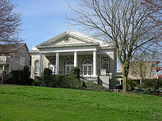
The former Fifth Church of Christ, Scientist, located at 3515 South Alaska Street in the Columbia City neighborhood in the Rainier Valley area of Seattle, Washington, is an historic Christian Science church edifice, whose original entrance was on 36th Avenue. South. Built in 1921. was designed by Earl A. Roberts in the Greek Revival and Neo-Palladian styles. It is a contributing property in the Columbia City Historic District, which was added to the National Register of Historic Places on September 8, 1980. Fifth Church is no longer in existence. The building is now the Rainier Arts Center. The only major exterior change made by the center was the relocation of the front entrance to Alaska Street.