
The Seattle Colleges District, also known simply as Seattle Colleges, is a group of colleges located in Seattle, Washington. It consists of three colleges—North Seattle College, Seattle Central College, South Seattle College —and, formerly, the Seattle Vocational Institute, which closed in 2019. Together the colleges form the second largest institution of higher education in the state, behind the University of Washington, to which many of their graduates transfer.

The Century 21 Exposition was a world's fair held April 21, 1962, to October 21, 1962, in Seattle, Washington, United States. Nearly 10 million people attended the fair during its six-month run.

Bryn Mawr-Skyway is a census-designated place (CDP) in King County, Washington, United States. The population was 17,397 at the 2020 census.

Kenmore is a city in King County, Washington, United States, along the northernmost shore of Lake Washington. It is a suburban commuter town at the mouth of the Sammamish River, 12 miles (19 km) northeast of downtown Seattle and 2 miles (3.2 km) west of Bothell. The population was 20,460 at the 2010 census. Kenmore Air Harbor is the largest seaplane-only passenger facility of its kind in the United States.

Shoreline is a city in King County, Washington, United States. It is located between the city limits of Seattle and the Snohomish County border, approximately 9 miles (14 km) north of Downtown Seattle. As of the 2020 census, the population of Shoreline was 58,608, making it the 22nd largest city in the state. Based on per capita income, one of the more reliable measures of affluence, Shoreline ranks 91st of 522 areas in the state of Washington to be ranked.
Columbia City is a neighborhood located in the southeastern part of Seattle, Washington in the Rainier Valley district. It has a landmark-protected historic business district and is one of the few Seattle neighborhoods with a long history of ethnic and income diversity.

West Seattle is a conglomeration of neighborhoods in Seattle, Washington, United States. It comprises two of the thirteen districts, Delridge and Southwest, and encompasses all of Seattle west of the Duwamish River. It was incorporated as an independent town in 1902 before being annexed by Seattle five years later. Among the area's attractions are its saltwater beach parks along Elliott Bay and Puget Sound, including Alki Beach Park and Lincoln Park. The area is also known for its views of the Olympic Mountains to the west and the Cascade Range to the east. One-third of Seattle's green space and urban forest is located in West Seattle, much of it in the West Duwamish Greenbelt.

Greenwood is a neighborhood in north central Seattle, Washington, United States. The intersection of Greenwood Avenue North and North 85th Street is the commercial center. Greenwood is known for its numerous bars, restaurants, coffee houses, theatres and specialty stores. Greenwood's main thoroughfares are Greenwood Avenue North and North 80th and 85th streets.
United Indians of All Tribes is a non-profit foundation that provides social and educational services to Native Americans in the Seattle metropolitan area and aims to promote the well being of the Native American community of the area. The organization is based at the Daybreak Star Cultural Center in Seattle, Washington's Discovery Park. UIATF has an annual budget of approximately $4.5 million as of 2013.
Cascade is an urban neighborhood abutting Downtown Seattle, Washington, United States, located adjacent to South Lake Union. It is bounded by: Fairview Avenue North on the west, beyond which is the rest of the Cascade Neighborhood; the Interstate 5 interchange for Mercer St to the north, beyond which is Eastlake; Interstate 5 on the east, beyond which is Capitol Hill; and Denny Way on the south, beyond which is Denny Triangle. It is surrounded by thoroughfares Mercer Street (eastbound), Fairview Avenue N. and Eastlake Avenue E., and Denny Way. The neighborhood, one of Seattle's oldest, originally extended much further: west to Terry Avenue, south to Denny Hill on the South, and east to Melrose Avenue E through the area now obliterated by Interstate 5. Some recent writers consider Cascade to omit the northern "arm", while others extend it westward to cover most of South Lake Union.
South Lake Union is a neighborhood in Seattle, Washington, so named because it is at the southern tip of Lake Union.

Delridge is a district in Seattle, Washington, United States that stretches along Delridge Way, an arterial that follows the eastern slope of the valley of Longfellow Creek, from near its source just within the southern city limits north to the West Seattle Bridge over the Duwamish River. It is generally associated with the neighborhing district of West Seattle, or even considered a sub-district of West Seattle.

Yesler Terrace is a 22-acre (8.9 ha) mixed-income, mixed-use neighborhood in Seattle, Washington, United States. It was originally completed in 1941 as the state's first public housing development and the first racially integrated public housing development in the United States. It occupies much of the area formerly known as Yesler Hill, Yesler's Hill, or Profanity Hill. In the early 2000s, the Seattle Housing Authority, began a redevelopment plan to transform the neighborhood into a mixed-income, mixed use community with multi-story buildings, parks, and community amenities.
Fort Lawton was a United States Army post located in the Magnolia neighborhood of Seattle, Washington overlooking Puget Sound. In 1973 a large majority of the property, 534 acres of Fort Lawton, was given to the city of Seattle and dedicated as Discovery Park. Both the fort and the nearby residential neighborhood of Lawton Wood are named after Major General Henry Ware Lawton.

Frank B. Cooper Elementary School, usually called Cooper School, serves students from kindergarten through 5th grade. Located in the Pigeon Point neighborhood of Delridge, Seattle, Washington, it is part of the Seattle Public Schools district. The school's 14-acre (57,000 m2) site is immediately adjacent to the 182-acre (0.74 km2) West Duwamish Greenbelt, one of Seattle's largest wildlife habitat corridors. This rich natural environment enhances the school's environmental education program.
The South End (Soufend) is a group of neighborhoods in the southeast of Seattle, Washington, U.S.A. The definition is a bit fluid, but has traditionally included the area south of the Central District, and east of Interstate 5: Rainier Valley, Columbia City, Rainier Beach, Seward Park, Mount Baker, and Beacon Hill. Sometimes its definition is extended to Skyway and Bryn Mawr in unincorporated King County, though these are not technically in the city. Other definitions have included northern parts of Renton and Tukwila, though most Seattleites, especially those from the South End, would consider this usage incorrect. Often the term "South End" is used colloquially to include neighboring portions of South King County, by people living in those areas, due to that area's location in reference to Seattle proper.
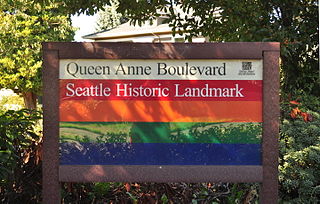
Queen Anne Boulevard is a 6.0-kilometre (3.7 mi) loop atop Seattle, Washington's Queen Anne Hill. It is a City of Seattle landmark. Authorized in 1907 and built from 1911 to 1916, it incorporates parts of 5th, 7th, 8th and 10th Avenues West; Bigelow Avenue North; West Blaine, McGraw, Wheeler, Fulton and Raye Streets; Smith, McGraw, and Wheeler Streets; West Highland Drive; and West McGraw and McGraw Places.

Pike Place Market is a public market in Seattle, Washington, United States. It opened on August 17, 1907, and is one of the oldest continuously operated public farmers' markets in the United States. Overlooking the Elliott Bay waterfront on Puget Sound, it serves as a place of business for many small farmers, craftspeople and merchants. It is named for its central street, Pike Place, which runs northwest from Pike Street to Virginia Street on the western edge of Downtown Seattle. Pike Place Market is Seattle's most popular tourist destination and the 33rd most visited tourist attraction in the world, with more than 10 million annual visitors.

Marra Farm, a 4-acre (1.6 ha) plot of land in Marra-Desimone Park, South Park, Seattle, Washington is one of only two historic agricultural parcels inside Seattle city limits that retains an agricultural use today; the other is Picardo Farm.

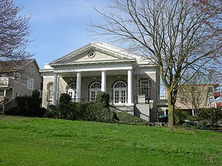
John Stanford International School is an elementary school located in the Wallingford neighborhood of Seattle, Washington, United States. It serves grades K-5 in the Seattle School District and offers a dual-immersion program in Japanese and Spanish that is available to all students. Formerly known as Latona School, the school is named for the late John Stanford, superintendent of the Seattle School District, who died on 28 November 1998. The historic school building (1906) is a designated City of Seattle Landmark.
