
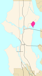
Bryn Mawr-Skyway is a census-designated place (CDP) in King County, Washington, United States. The population was 17,397 at the 2020 census.

Newcastle is an Eastside city in King County, Washington, United States. The population was 10,380 at the 2010 census and an estimated 12,292 in 2019.

Renton is a city in King County, Washington, and an inner-ring suburb of Seattle. Situated 11 miles (18 km) southeast of downtown Seattle, Renton straddles the southeast shore of Lake Washington, at the mouth of the Cedar River. As of the 2020 census, the population of Renton was 106,785, up from 90,927 at the 2010 census. The city is currently the sixth-largest municipality in greater Seattle and the nineth-largest in Washington state.

Shoreline is a city in King County, Washington, United States. It is located between the city limits of Seattle and the Snohomish County border, approximately 9 miles (14 km) north of Downtown Seattle. As of the 2020 census, the population of Shoreline was 58,608, making it the 22nd largest city in the state. Based on per capita income, one of the more reliable measures of affluence, Shoreline ranks 91st of 522 areas in the state of Washington to be ranked.

The Chinatown–International District of Seattle, Washington is the center of Seattle's Asian American community. Within the Chinatown International District are the three neighborhoods known as Seattle's Chinatown, Japantown and Little Saigon, named for the concentration of businesses owned by people of Chinese, Japanese and Vietnamese descent, respectively. The geographic area also once included Seattle's Manilatown. The name Chinatown/International District was established by City Ordinance 119297 in 1999 as a result of the three neighborhoods' work and consensus on the Seattle Chinatown International District Urban Village Strategic Plan submitted to the City Council in December 1998. Like many other areas of Seattle, the neighborhood is multiethnic, but the majority of its residents are of Chinese ethnicity. It is one of eight historic neighborhoods recognized by the City of Seattle. CID has a mix of residences and businesses and is a tourist attraction for its ethnic Asian businesses and landmarks.

Green Lake is a neighborhood in north central Seattle, Washington. Its centerpiece is the lake and park after which it is named.
Columbia City is a neighborhood located in the southeastern part of Seattle, Washington in the Rainier Valley district. It has a landmark-protected historic business district and is one of the few Seattle neighborhoods with a long history of ethnic and income diversity.

West Seattle is a conglomeration of neighborhoods in Seattle, Washington, United States. It comprises two of the thirteen districts, Delridge and Southwest, and encompasses all of Seattle west of the Duwamish River. It was incorporated as an independent town in 1902 before being annexed by Seattle five years later. Among the area's attractions are its saltwater beach parks along Elliott Bay and Puget Sound, including Alki Beach Park and Lincoln Park. The area is also known for its views of the Olympic Mountains to the west and the Cascade Range to the east. One-third of Seattle's green space and urban forest is located in West Seattle, much of it in the West Duwamish Greenbelt.
Beacon Hill is a hill and neighborhood in southeast Seattle, Washington. It is roughly bounded on the west by Interstate 5, on the north by Interstate 90, on the east by Rainier Avenue South, Cheasty Boulevard South, and Martin Luther King Junior Way South, and on the south by the Seattle city boundary. It is part of Seattle's South End.
The Central Area, commonly called the Central District or The CD, is a mostly residential district in Seattle located east of downtown and First Hill ; west of Madrona, Leschi and Mt. Baker; south of Capitol Hill, and north of Rainier Valley. Historically, the Central District has been one of Seattle's most racially and ethnically diverse neighborhoods, and was once the center of Seattle's black community and a major hub of African-American businesses.
Laurelhurst is a residential neighborhood in Seattle, Washington, USA. It is bounded on the northeast by Ivanhoe Place N.E., beyond which is Windermere; on the northwest by Sand Point Way N.E. and N.E. 45th Street, beyond which are Hawthorne Hills, Ravenna, and University Village; on the west by Mary Gates Memorial Drive N.E., beyond which is the East Campus of the University of Washington; on the southwest by Union Bay; and on the east by Lake Washington. Seattle Children's Hospital is located in its northwest corner. Once a seasonal campground of the Duwamish people, the neighborhood has been a part of Seattle since its annexation in 1910.

Mount Baker is a neighborhood in southeast Seattle. The neighborhood's name comes from the view of Mount Baker in Whatcom County, that is seen by looking north over Lake Washington. It is bounded by Lake Washington to the east, Interstate 90 and then Leschi to the north, Rainier Valley to the west, and Columbia City to the south. The neighborhood has a community club and a rowing team. It hosts Seattle's annual Seafair, which includes an airshow featuring the U.S. Navy Blue Angels, hydroplane races, a fireworks show, and other festivities. Franklin High School and Garfield High School serve this area. It is part of Seattle's South End.

The Rainier Valley is a district in southeast Seattle. It is located east of Beacon Hill; west of Mount Baker, Seward Park, and Leschi; south of the Central District and north of Rainier Beach. It is part of Seattle's South End.

Yesler Terrace, a 22-acre (8.9 ha) public housing development in Seattle, Washington was, at the time of its completion in 1941, Washington state's first public housing development and the first racially integrated public housing development in the United States. It occupies much of the area formerly known as Yesler Hill, Yesler's Hill, or Profanity Hill. The development is administered by the Seattle Housing Authority, who have been redeveloping the neighborhood into a mixed-income area with multi-story buildings and community amenities since 2013.
Dunlap is a neighborhood in south Seattle, Washington, just north of Rainier Beach. It is home to Dunlap Elementary School, part of the Seattle Public Schools. Dunlap is named after Joseph Dunlap, the first homesteader in the area.

Rainier Beach is a set of neighborhoods in Seattle, Washington that are mostly residential. Also called Atlantic City, Rainier Beach can include Dunlap, Pritchard Island, and Rainier View neighborhoods.
Lakeridge is a hillside neighborhood near Lake Washington located mostly in unincorporated Skyway/West Hill in King County, Washington and partially in the southeast portion of the City of Seattle's Rainier Beach neighborhood. Its boundaries extend from Seattle's Rainier Beach neighborhood on the north, to Lake Washington on the east, to unincorporated Bryn Mawr on the southeast and unincorporated Skyway on the southwest.

Rainier Beach High School is a public secondary school in the Seattle Public Schools system. It is located in the Rainier Beach area, in the southeastern part of the city of Seattle, Washington, United States. The school historically has had a strong emphasis on team sports, and many championship teams. The building has a capacity of 1,200 students, but enrollment has declined greatly in recent years. In 2006, 1,302 of the 1,600 high school students living in the Rainier Beach neighborhood traveled out of the area each morning to attend other high schools. In 2008–09, Rainier Beach began the year with 453 students and ended with about 295, giving an average monthly enrollment of 374. Sixty students chose it as their first choice. In 2013 the school began offering an International Baccalaureate program.

Hillman City is a primarily residential neighborhood of southeast Seattle, Washington, located in the Rainier Valley and centered about a half mile south of the Columbia City neighborhood. It was annexed by Seattle in January 1907, along with the rest of the town of Southeast Seattle.
KVRU-LP is a low-power local radio station in southeast Seattle, Washington. The station was formerly named Rainier Valley Radio after the Rainier Valley area, where it broadcasts. It is owned by Southeast Effective Development (SEED), a non-profit economic development agency serving southeastern Seattle, which raised $400,000 to fund the station. The station broadcasts from studios in the Rainier Square Plaza housing development. KVRU began broadcasting online in 2015 and launched on the FM frequency in September 2017.