Homestead, Missouri

Last updated
Homestead, Missouri
Ray County Missouri Incorporated and Unincorporated areas Homestead Highlighted.svg
Location of Homestead, Missouri
Coordinates: 39°21′47″N94°11′56″W / 39.36306°N 94.19889°W / 39.36306; -94.19889 Coordinates: 39°21′47″N94°11′56″W / 39.36306°N 94.19889°W / 39.36306; -94.19889
Country United States
State Missouri
County Ray
Area
[1]
  Total0.16 sq mi (0.41 km2)
  Land0.16 sq mi (0.41 km2)
  Water0.00 sq mi (0.00 km2)
Elevation
[2]
892 ft (272 m)
Population
 (2020)
  Total192
  Density1,207.55/sq mi (467.33/km2)
Time zone UTC-6 (Central (CST))
  Summer (DST) UTC-5 (CDT)
FIPS code 29-32806 [3]
GNIS feature ID2398536 [2]

Homestead is a village in Ray County, Missouri, and part of the Kansas City metropolitan area within the United States. As of the 2020 census, its population was 192. [4]

Contents

Geography

According to the United States Census Bureau, the village has a total area of 0.16 square miles (0.41 km2), all land. [5]

Demographics

Historical population
CensusPop.Note
1980 138
1990 17728.3%
2000 1812.3%
2010 1852.2%
2020 1923.8%
U.S. Decennial Census [6]

2010 census

As of the census [7] of 2010, there were 185 people, 71 households, and 50 families living in the village. The population density was 1,156.3 inhabitants per square mile (446.4/km2). There were 77 housing units at an average density of 481.3 per square mile (185.8/km2). The racial makeup of the village was 96.2% White, 1.6% African American, 1.1% Native American, and 1.1% from two or more races. Hispanic or Latino of any race were 0.5% of the population.

There were 71 households, of which 31.0% had children under the age of 18 living with them, 52.1% were married couples living together, 12.7% had a female householder with no husband present, 5.6% had a male householder with no wife present, and 29.6% were non-families. 26.8% of all households were made up of individuals, and 14.1% had someone living alone who was 65 years of age or older. The average household size was 2.61 and the average family size was 3.10.

The median age in the village was 42.1 years. 23.2% of residents were under the age of 18; 4.4% were between the ages of 18 and 24; 28.2% were from 25 to 44; 25.3% were from 45 to 64; and 18.9% were 65 years of age or older. The gender makeup of the village was 50.3% male and 49.7% female.

2000 census

As of the census [3] of 2000, there were 181 people, 72 households, and 57 families living in the village. The population density was 954.5 inhabitants per square mile (368.5/km2). There were 76 housing units at an average density of 400.8 per square mile (154.7/km2). The racial makeup of the village was 96.13% White, 2.21% African American, and 1.66% from two or more races.

There were 72 households, out of which 30.6% had children under the age of 18 living with them, 65.3% were married couples living together, 8.3% had a female householder with no husband present, and 20.8% were non-families. 20.8% of all households were made up of individuals, and 5.6% had someone living alone who was 65 years of age or older. The average household size was 2.51 and the average family size was 2.84.

In the village, the population was spread out, with 22.1% under the age of 18, 7.2% from 18 to 24, 24.3% from 25 to 44, 26.5% from 45 to 64, and 19.9% who were 65 years of age or older. The median age was 44 years. For every 100 females, there were 110.5 males. For every 100 females age 18 and over, there were 104.3 males.

The median income for a household in the village was $36,250, and the median income for a family was $37,321. Males had a median income of $29,375 versus $19,286 for females. The per capita income for the village was $14,324. About 10.2% of families and 8.9% of the population were below the poverty line, including 12.1% of those under the age of eighteen and none of those 65 or over.

Related Research Articles

<span class="mw-page-title-main">Lyons, Michigan</span> Village in Michigan, United States

Lyons is a village in Ionia County in the U.S. state of Michigan. The population was 789 at the 2010 census. Most of the village is within Lyons Township. A small portion extends west into Ionia Township.

<span class="mw-page-title-main">Fountain N' Lakes, Missouri</span> Village in Missouri, United States

Fountain N' Lakes is a village in Lincoln County, Missouri, United States. The population was 165 at the 2010 census.

<span class="mw-page-title-main">Cobalt, Missouri</span> Village in Missouri, United States

Cobalt Village is a village which is located in Madison County, Missouri, United States. As of the 2020 census, the population is 264.

<span class="mw-page-title-main">Velda Village Hills, Missouri</span> Village in Missouri, United States

Velda Village Hills is a village in northeastern St. Louis County, Missouri, United States. The population was 1,055 at the 2010 census.

<span class="mw-page-title-main">Westwood, Missouri</span> Village in Missouri, United States

Westwood is a village in west St. Louis County, Missouri, United States. The population was 278 at the 2010 census.

<span class="mw-page-title-main">Country Club, Missouri</span> Village in Missouri, United States

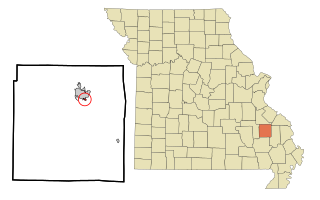
Country Club is a village in Andrew County, Missouri, United States. The population was 2,449 at the 2010 census. It is part of the St. Joseph, MO–KS Metropolitan Statistical Area.

<span class="mw-page-title-main">Baldwin Park, Missouri</span> Village in Missouri, United States

Baldwin Park is a village in Cass County, Missouri, United States. The population was 92 at the 2010 census. It is part of the Kansas City metropolitan area.

<span class="mw-page-title-main">New Weston, Ohio</span> Village in Ohio, United States

New Weston is a village in Darke County, Ohio, United States. The population was 136 at the 2010 census.

<span class="mw-page-title-main">Addyston, Ohio</span> Village in Ohio, United States

Addyston is a village in Miami Township, Hamilton County, Ohio, United States, along the Ohio River. The population was 927 at the 2020 census.

<span class="mw-page-title-main">West Farmington, Ohio</span> Village in Trumbull, Ohio, United States

West Farmington is a village in northwestern Trumbull County, Ohio, United States, along the Grand River. The population was 542 at the 2020 census. It is part of the Youngstown–Warren metropolitan area.

<span class="mw-page-title-main">Elgin, Ohio</span> Village in Ohio, United States

Elgin is a village in Van Wert County, Ohio, United States. The population was 57 at the 2010 census. It is included within the Van Wert, Ohio Micropolitan Statistical Area.

<span class="mw-page-title-main">Beech Bottom, West Virginia</span> Village in West Virginia, United States

Beech Bottom is a village in Brooke County, West Virginia, United States, situated along the Ohio River. The population was 523 at the 2010 census. It is part of the Weirton–Steubenville metropolitan area.

<span class="mw-page-title-main">Bethlehem, West Virginia</span> Village in West Virginia, United States

Bethlehem is a village in Ohio County, West Virginia, United States. It is part of the Wheeling, West Virginia Metropolitan Statistical Area. The population was 2,499 at the 2010 census.

<span class="mw-page-title-main">Clearview, West Virginia</span> Village in West Virginia, United States

Clearview is a village in Ohio County, West Virginia, United States. It is part of the Wheeling, West Virginia Metropolitan Statistical Area. The population was 565 at the 2010 census.

<span class="mw-page-title-main">Friesland, Wisconsin</span> Village in Wisconsin, United States

Friesland is a village in Columbia County, Wisconsin, United States. The population was 320 at the 2020 census. It is part of the Madison Metropolitan Statistical Area.

<span class="mw-page-title-main">Kekoskee, Wisconsin</span> Village in Wisconsin, United States

Kekoskee is a village in Dodge County, Wisconsin, United States. The population was 161 at the 2010 census.

<span class="mw-page-title-main">Tennyson, Wisconsin</span> Village in Wisconsin, United States

Tennyson is a village in Grant County, Wisconsin, United States, originally called Dutch Hollow. The population was 355 at the 2010 census.

<span class="mw-page-title-main">Browntown, Wisconsin</span> Village in Wisconsin, United States

Browntown is a village in Green County, Wisconsin, United States. The population was 280 at the 2010 census.

<span class="mw-page-title-main">Bloomington, Wisconsin</span> Village in Wisconsin, United States

Bloomington is a village in Grant County, Wisconsin, United States. The population was 735 as of the 2010 census. The village is located within the Town of Bloomington.

<span class="mw-page-title-main">Aniwa, Wisconsin</span> Village in Wisconsin, United States

Aniwa is a village in Shawano County, Wisconsin, United States. The population was 260 at the 2010 census. The village is located within the Town of Aniwa. U.S. Route 45 runs north–south through the village.

References

  1. "ArcGIS REST Services Directory". United States Census Bureau. Retrieved August 28, 2022.
  2. 1 2 U.S. Geological Survey Geographic Names Information System: Homestead, Missouri
  3. 1 2 "U.S. Census website". United States Census Bureau . Retrieved 2008-01-31.
  4. "Explore Census Data". data.census.gov. Retrieved 2021-12-29.
  5. "US Gazetteer files 2010". United States Census Bureau. Archived from the original on 2012-01-25. Retrieved 2012-07-08.
  6. "Census of Population and Housing". Census.gov. Retrieved June 4, 2015.
  7. "U.S. Census website". United States Census Bureau . Retrieved 2012-07-08.