Related Research Articles

Ray County is a county located in the northwestern portion of the U.S. state of Missouri and is part of the Kansas City metropolitan area. As of the 2020 census, the population was 23,158. Its county seat is Richmond. The county was organized November 16, 1820 and named for John Ray, a Missouri state legislator and member of the first state Constitutional Convention.

Jackson County is located in the western portion of the U.S. state of Missouri, on the border with Kansas. As of the 2020 census, the population was 717,204. making it the second-most populous county in the state. Largely suburban it is the most populated county in the Kansas City metropolitan area consisting of mostly detached single family homes.

Caldwell County is a county located in Missouri, United States. As of the 2020 census, the county's population was 8,815. It is part of the Kansas City metropolitan area. Its county seat is Kingston. The county was organized December 29, 1836 and named by Alexander Doniphan to honor John Caldwell, who participated in George Rogers Clark's Native American Campaign of 1786 and was the second Lieutenant Governor of Kentucky.
The Danites were a fraternal organization founded by Latter Day Saint members in June 1838, in the town of Far West, Caldwell County, Missouri. During their period of organization in Missouri, the Danites operated as a vigilante group and took a central role in the events of the 1838 Mormon War. They remained an important part of Mormon and non-Mormon folklore, polemics, and propaganda for the remainder of the 19th century, waning in ideological prominence after Utah gained statehood. Notwithstanding public excommunications of Danite leaders by the Church and both public and private statements from Joseph Smith referring to the band as being both evil in nature and a "secret combination", the nature and scope of the organization and the degree to which it was officially connected to the Church of Christ are not agreed between historians. Early in the group's existence, Joseph Smith appeared to endorse its actions, but later turned against it as violence increased and the actions of the Danites inspired a hysteria in Missouri that eventually led to the Extermination Order. According to an essay on the website of the Church of Jesus Christ of Latter-day Saints, "Historians generally concur that Joseph Smith approved of the Danites but that he probably was not briefed on all their plans and likely did not sanction the full range of their activities."

Adam-ondi-Ahman is a historic site in Daviess County, Missouri, about five miles south of Jameson. It is located along the east bluffs above the Grand River. According to the teachings of The Church of Jesus Christ of Latter-day Saints, it is the site where Adam and Eve lived after being expelled from the Garden of Eden. It teaches that the place will be a gathering spot for a meeting of the priesthood leadership, including prophets of all ages and other righteous people, prior to the Second Coming of Jesus Christ.
The 1838 Mormon War, also known as the Missouri Mormon War, was a conflict between Mormons and non-Mormons in Missouri from August to November 1838, the first of the three "Mormon Wars".

Missouri Executive Order 44 was a state executive order issued by Missouri Governor Lilburn Boggs on October 27, 1838, in the aftermath of the Battle of Crooked River – a clash between members of the Church of Jesus Christ of Latter-day Saints and a unit of the state militia in northern Ray County during the 1838 Mormon War.

Lyman Wight was an early leader in the Latter Day Saint movement. He was the leader of the Latter Day Saints in Daviess County, Missouri, in 1838. In 1841, he was ordained a member of the Quorum of the Twelve Apostles. After the death of Joseph Smith resulted in a succession crisis, Wight led his own break-off group of Latter Day Saints to Texas, where they created a settlement. While in Texas, Wight broke with the main body of the group led by Brigham Young. Wight was ordained president of his own church, but he later sided with the claims of William Smith, and eventually of Joseph Smith III. After his death, most of the "Wightites" joined with the Reorganized Church of Jesus Christ of Latter Day Saints.

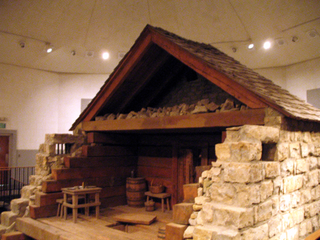
Far West was a settlement of the Latter Day Saint movement in Caldwell County, Missouri, United States, during the late 1830s. It is recognized as a historic site by the U.S. National Register of Historic Places, added to the register in 1970. It is owned and maintained by the Church of Jesus Christ of Latter-day Saints.


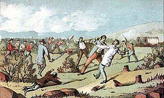
The Haun’s Mill Massacre occurred on October 30, 1838, when a mob/militia unit from Livingston County, Missouri, attacked a Mormon settlement in eastern Caldwell County, Missouri, after the Battle of Crooked River. By far the bloodiest event in the 1838 Mormon War in Missouri, it has long been remembered by the members of the Latter Day Saint movement. While the spelling "Haun" is common when referring to the massacre or the mill where it occurred, the mill's owner used the spelling "Hawn" in legal documents.

The Crooked River is a tributary of the Missouri River in west-central Missouri in the United States. The stream has also been known historically as "Big Creek," "Little River" and "Tiger River." The Crooked River was named for its meandering disposition. Big Creek refers to the stream's status as the largest tributary to the Missouri River in the county.
Florence is a neighborhood in Omaha, Nebraska, United States on the city's north end and originally one of the oldest cities in Nebraska. It was incorporated by the Nebraska Territorial Legislature on March 10, 1857. The site of Winter Quarters for Mormon migrants traveling west, it has the oldest cemetery for people of European descent and oldest standing gristmill in Nebraska. Florence was the site of an illegal territorial legislature in 1858. Given the high concentration of National Register of Historic Places in the neighborhood, it is regarded as "the historic front door to Omaha as well as the state."
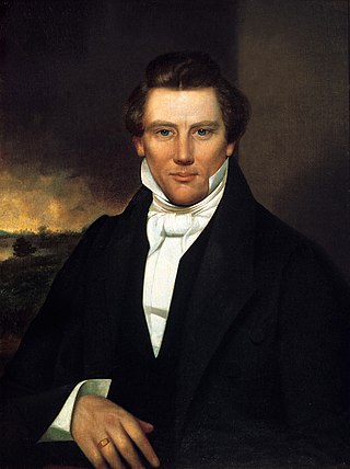
The life of Joseph Smith from 1838 to 1839, when he was 33–34 years old, covers a period beginning when Smith left Ohio in January 1838 until he left Missouri and moved to Nauvoo, Illinois in 1839.

Bearden, also known as Bearden Village, is a neighborhood in Knoxville, Tennessee, United States, located along Kingston Pike in West Knoxville. Developed primarily as an agrarian community in the 19th century, this neighborhood now lies at the heart of one of Knoxville's major commercial corridors. Named for former Knoxville mayor and Tennessee state legislator, Marcus De Lafayette Bearden (1830–1885), the community was annexed by Knoxville in 1962.
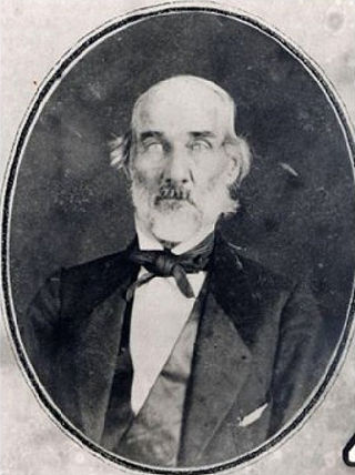
Samuel Bogart was an itinerant Methodist minister and militia captain from Ray County, Missouri who played a prominent role in the 1838 Missouri Mormon War before later moving to Collin County, Texas, where he became a Texas Ranger and a member of the Texas State Legislature. He is best remembered, however, for his role in leading opposition to Mormon settlers in northwestern Missouri, and for the active role he took in operations against them in the fall of 1838. These operations led to the expulsion of nearly all Mormons from the state following the issuance of Governor Lilburn Boggs' infamous Extermination Order in October of that year.
St. Cloud is an unincorporated community in Ray County, in the U.S. state of Missouri and part of the Kansas City metropolitan area.
Sandals is an unincorporated community in Ray County, in the U.S. state of Missouri.
Taitsville is an unincorporated community in northern Ray County, in the U.S. state of Missouri and part of the Kansas City metropolitan area.
References
- ↑ U.S. Geological Survey Geographic Names Information System: Knoxville, Missouri
- ↑ Missouri Atlas & Gazetteer, DeLorme, 1st ed., 1998, p. 28 ISBN 0899332242
- ↑ Eaton, David Wolfe (1917). How Missouri Counties, Towns and Streams Were Named. The State Historical Society of Missouri. pp. 345.
- ↑ Moser, Arthur Paul. A Directory of Towns, Villages, and Hamlets Past and Present of Ray County, Missouri
- ↑ "Ray County Place Names, 1928–1945". The State Historical Society of Missouri. Archived from the original on June 24, 2016. Retrieved December 12, 2016.
- ↑ Atchison, Ann. Place Names of Five West Central Counties of Missouri. M.S. thesis, University of Missouri-Columbia, 1937.
- ↑ "Post Offices". Jim Forte Postal History. Retrieved December 12, 2016.
- ↑ History of Caldwell and Livingston Counties, Missouri, pp. 104-105
- ↑ LeSueur, Stephen C. "Missouri's Failed Compromise: The Creation of Caldwell County for the Mormons," The Journal of Mormon History, Vol. 31, No. 3, 2005.
Municipalities and communities of Ray County, Missouri, United States | ||
|---|---|---|
| Cities |  | |
| Villages | ||
| Townships | ||
| CDPs | ||
| Other communities | ||
| Ghost town | ||
| Footnotes | ‡This populated place also has portions in an adjacent county or counties | |
39°26′46″N94°01′01″W / 39.44611°N 94.01694°W
| | This Ray County, Missouri state location article is a stub. You can help Wikipedia by expanding it. |