
Downtown is the largest business district in the city of Houston and the largest in the state of Texas, located near the geographic center of the metropolitan area at the confluence of Interstate 10, Interstate 45, and Interstate 69. The 1.84-square-mile (4.8 km2) district, enclosed by the aforementioned highways, contains the original townsite of Houston at the confluence of Buffalo Bayou and White Oak Bayou, a point known as Allen's Landing. Downtown has been the city's preeminent commercial district since its founding in 1836.

Chinatown is a community in Southwest Houston, Texas, United States.

Greenway Plaza is a business district located along Interstate 69 within the Interstate 610 loop in southwestern Houston, Texas, 5 miles (8.0 km) west of Downtown and 3 miles (4.8 km) east of Uptown. The district is located immediately west of Upper Kirby, north of West University Place, and south of River Oaks.
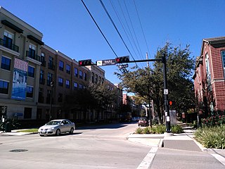
Midtown is a central neighborhood of Houston, located west-southwest of Downtown. Separated from Downtown by an elevated section of Interstate 45, Midtown is characterized by a continuation of Downtown's square grid street plan, anchored by Main Street and the METRORail Red Line. Midtown is bordered by Neartown (Montrose) to the west, the Museum District to the south, and Interstate 69 to the east. Midtown's 325 blocks cover 1.24 square miles (3.2 km2) and contained an estimated population of nearly 8,600 in 2015.

Northside High School, formerly Jefferson Davis High School, is a secondary school located at 1101 Quitman in the Near Northside neighborhood of Northside, Houston, Texas with a ZIP code of 77009. The school was previously named after Jefferson Davis, the only president of the Confederate States of America.

Edgar Gregory-Abraham Lincoln Education Center (GLEC) is a K-8 school located at 1101 Taft in the Fourth Ward area of Houston, Texas, United States. Gregory-Lincoln is a part of the Houston Independent School District (HISD) and has a fine arts magnet program that takes students in both the elementary and middle school levels. Originally built in 1966 as Lincoln Junior and Senior High School, it later operated as Lincoln Junior High School until Gregory Elementary School merged into it in 1980, forming Gregory-Lincoln. The school moved into its current building in 2008; the rebuilding was delayed due to concerns that U.S. Civil War-era graveyards would be disturbed by the rebuilding process.

Fourth Ward is one of the historic six wards of Houston, Texas, United States. The Fourth Ward is located inside the 610 Loop directly west of and adjacent to Downtown Houston. The Fourth Ward is the site of Freedmen's Town, which was a post-U.S. Civil War community of African-Americans.

Montrose is a neighborhood located in west-central Houston, Texas, United States. Montrose is a 7.5-square-mile (19 km2) area roughly bounded by Interstate 69/U.S. Highway 59 to the south, Allen Parkway to the north, South Shepherd Drive to the west, and Taft to Fairview to Bagby to Highway 59 to Main to the east. The area is also referred to as Neartown or Neartown / Montrose.
Near Northside is a historic neighborhood located in Northside, Houston, Texas. Near Northside is primarily occupied by people of Hispanic descent.
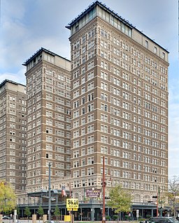
The Rice, formerly the Rice Hotel, is an historic building at 909 Texas Avenue in Downtown Houston, Texas, United States. The current building is the third to occupy the site. It was completed in 1913 on the site of the former Capitol building of the Republic of Texas, and is listed on the National Register of Historic Places. The old Capitol building was operated as a hotel until it was torn down and replaced by a new hotel around 1881. Jesse H. Jones built a new seventeen-story, double-winged hotel in 1913, also called "The Rice Hotel." This building underwent major expansions: adding a third wing in 1925, adding an eighteenth floor in 1951, and adding a five-story "motor lobby" in 1958. In addition, there were several renovations during its life as a hotel. It continued to operate as a hotel before finally shutting down in 1977. After standing vacant for twenty-one years, The Rice was renovated as apartments and reopened in 1998 as the Post Rice Lofts. It was sold in 2014 and renamed simply The Rice.

Four Seasons Hotel Houston is a hotel in Houston, Texas, United States. It is operated by Four Seasons Hotels and Resorts. The hotel includes Four Seasons Place, a group of 64 apartment units, and an Italian restaurant. It is a part of the Houston Center complex.
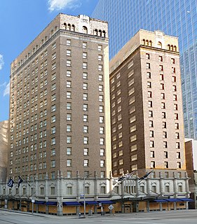
The Club Quarters Hotel is a 16-story, 61.6 m (202 ft) Beaux-Arts high-rise at 710 Fannin Street in downtown Houston, Texas, United States. The building is listed on the National Register of Historic Places as the Texas State Hotel.

One Park Place is a 518 ft tall apartment building located adjacent to Discovery Green park in downtown Houston, Texas. Completed by The Finger Companies in May 2009, the building has 340 units on 30 floors with a total height of 501 feet (153 m) and 37 floors.
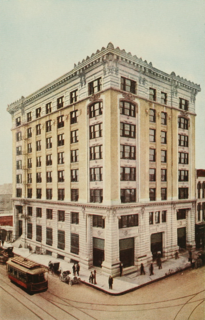
Franklin Lofts, originally known as the Lomas & Nettleton Building, is an 8-story, 32 m (105 ft) building in downtown Houston, Texas. The building is generally regarded as the first skyscraper in the city. The Lomas & Nettleton Building was completed in 1904, and rises 8 floors in height. A new addition was completed in 1925. It was also the tallest steel-framed building west of the Mississippi River at the time of its completion.

The Northside is a district of Houston, Texas, United States. It is within the Greater Northside Management District.

The Westmoreland Historic District is a neighborhood in Neartown Houston, Texas. It is west of Spur 527, between Westheimer Road and West Alabama Street.
The Montrose District was a management district located in Houston, Texas, United States. The land was governed by the Montrose Management District.
Somerset Green is a gated community in Houston, Texas, developed by Hines Interests Limited Partnership. Nancy Sarnoff of the Houston Chronicle described Somerset Green as "a European-style residential development". Preston Wood & Associates was the land planner of the development.
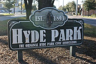
Hyde Park is a historic community located in the Montrose neighborhood of Houston, Texas. Its southeast boundary is the intersection Montrose Boulevard and Westheimer. The neighborhood was established in the late 1800s on the summer farm of the second President of the Republic of Texas, Mirabeau Lamar. In the 1970s, Hyde Park became a central part of the Gay Rights Movement in Houston. Like much of Montrose, the neighborhood is now experiencing significant gentrification, and is home to an abundance of restaurants, including Mexican, Italian, Greek, American, Lebanese, coffee houses, and numerous bars.
Houston Housing Authority (HHA), formerly Housing Authority of the City of Houston (HACH), is the public housing authority in Houston, Texas.

