
Gales Ferry is a village in the town of Ledyard, Connecticut, United States. It is located along the eastern bank of the Thames River. The village developed as a result of having a ferry to Uncasville located at this site, and from which the village was named. Gales Ferry was listed as a census-designated place for the 2010 Census, with a population of 1,162.

Sinking Springs Farms is a historic farm and national historic district located at Manchester Township in York County, Pennsylvania.
Towles Farmstead, also known as Goshen Plantation and Plainsfield, is a historic farmstead and national historic district located near Meggett, Charleston County, South Carolina. The district encompasses 11 contributing buildings, 2 contributing sites, and 1 contributing structure. They include two early-20th century residences: a one-story, frame house constructed about 1903, with characteristic Neo-Classical and Bungalow features; and a two-story, rectangular frame house constructed in 1930, with characteristic Colonial Revival and Italian Renaissance features. Associated with the houses are a variety of contributing utility outbuildings.
The William and Amanda J. Ellis Farmstead Historic District is a nationally recognized historic district located near Elliott, Iowa, United States. It was listed on the National Register of Historic Places in 2015. At the time of its nomination it contained four resources, which included two contributing buildings, and two non-contributing buildings. William and Amanda Jane Ellis owned this farm from 1882 to 1919. During that time the Queen Anne style house with Stick influences and the heavy timber frame barn were built. Both were constructed around 1900. Two garages are the non-contributing buildings.

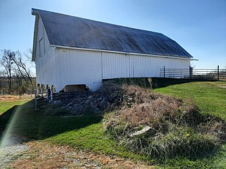
The Vander Wilt Farmstead Historic District, also known as the Heritage House Bed and Breakfast, is an agricultural historic district located north of Leighton, Iowa, United States. At the time of its nomination it included three contributing buildings, three contributing structures, one non-contributing building, and two non-contributing structures. The significance of the district is attributed to its association with progressive farming and the Country Life Movement, which sought to improve the living conditions of rural residents. The contributing buildings include the 1904 barn, the house (1920), the corn crib (1953), dairy barn (1955) and the feed lots. The two-story house was built by Douwe Sjaardema, a contractor from Pella, Iowa. The corn crib was built by the Iowa Concrete Crib & Silo Co. of Des Moines. The farm also includes a former landing strip for airplanes. It featured a 1,500-foot (460 m) grass runway where cows grazed on certain days. At one time it had a windsock and homemade landing lights. A hangar, no longer in existence, had been built in 1955. An automobile garage and two silos are the non-contributing resources. The district was listed on the National Register of Historic Places in 2004. The 1904 barn has subsequently been torn down.
The Duncan–Duitsman Farm Historic District is a nationally recognized agricultural historic district located northeast of George, Iowa, United States. It was listed on the National Register of Historic Places in 1994. At the time of its nomination it contained 19 resources, which included 12 contributing buildings, four contributing sites, one contributing structure, and two non-contributing buildings. Its historic importance is derived from being two pioneer farmsteads from the last section of Iowa opened to settlement.
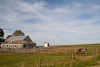
Nelson–Pettis Farmsteads Historic District, also known as Poverty Hill, is a national historic district located at St. Joseph, Missouri. The district encompasses four contributing buildings, three contributing sites, and one contributing structure on two adjoining farmsteads - the Nelson farmstead and the Pettis farmstead. The contributing resources are the Nelson I-house farmhouse, root cellar, the Nelson family cemetery, the Pettis farmhouse, the barn, the corn crib / shed, and the agricultural fields.
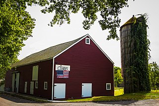
Big Hill Farmstead Historic District is a historic home and farm and national historic district located at Jackson, Cape Girardeau County, Missouri. The farmhouse was built about 1855, and is a two-story, five bay, brick I-house with Greek Revival and Italianate style design elements. It has a hipped roof and features a gallery porch. Other contributing elements are the a timber frame barn, a cabin/workshop, a wagon shed, and the surrounding farmland.

Dulle Farmstead Historic District, also known as Pleasant Home Farm, is a historic home and farm and national historic district located near Jefferson City, Cole County, Missouri. It encompasses nine contributing buildings and one contributing structure and include the brick I-house form farmhouse (1902), the multi-purpose barn, the cattle barn (1933), the ice house, the garage (1942), two chicken shelters, two brooder houses, and an oak plank and iron beam bridge (1934).
John A. Adams Farmstead Historic District, also known as Cedarcroft Farm, is a historic home and farm and national historic district located near Warrensburg, Johnson County, Missouri. The district consists of four contributing properties—three contributing buildings and one contributing structure. The buildings are a house, a barn, and a barn. The structure is a system of sewer and drainage tiles and dams constructed beginning in 1875 and which underlays much of the district.
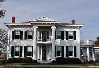
Culbertson–Head Farmstead is a historic home, farm, and national historic district located near Palmyra, Marion County, Missouri. The house was built about 1854–1855, and is a two-story, "L"-shaped, Greek Revival style brick dwelling. It features a two-story front portico. Also on the property are the contributing smokehouse / ice house (pre-1915); shop ; large Jamesway, gambrel roof barn (1927); gabled roofed, wood granary ; and transverse crib barn (1880s).
Louis Bruce Farmstead Historic District, also known as Rock Enon Farm, is a historic home and farm and national historic district located near Russellville, Moniteau County, Missouri. The district encompasses six contributing buildings and one contributing structure associated with a late-19th century farmstead. They are the house (1872-1876), a smokehouse / multipurpose building (c.1870-76), a privy, a spring house (1873), a granary, a substantial barn (1870), and a stone retaining wall with a swinging iron gate and carriage steps. The house is a 2 1/2-story, five bay, central hall I-house constructed of limestone blocks. It has a gable roof and a three-bay front porch.
The Osage Farms Resettlement Properties in Pettis County, Missouri is a National Register of Historic Places multiple property submission located at Pettis County, Missouri. The submission includes 10 national historic districts and 2 individual properties listed on the National Register of Historic Places. The properties included were built by the Resettlement Administration / Farm Security Administration in 1937 as model farms and known as Osage Farms. Model farmsteads typically included a 1+1⁄2-story frame dwelling, barn, poultry house and privy.
Isiah Mansur Farmstead Historic District, also known as Rock Hall, is a historic home and farm and national historic district located near Richmond, Ray County, Missouri. The district encompasses eight contributing buildings, one contributing site, and three contributing structures on a farm developed between the mid-19th and mid-20th centuries. The contributing resources include the main farmhouse, a buggy house, a large barn, an engine house (c.1900), a small barn, a brooder house, a hen house, a smokehouse, a house well, a field well, and a wellhouse. The main farmhouse is a two-story, five bay, frame I-house.
Starke–Meinershagen–Boeke Rural Historic District is a historic national historic district located near Marthasville, Warren County, Missouri. The district encompasses seven contributing buildings on an 1860s farmstead. The contributing buildings are a two-story, brick I-house and brick smokehouse dated between 1863 and 1870; and a gambrel roof barn, two machine sheds, a garage, and a hen house dated to the early-20th century.

The Jan F. and Antonie Janko Farmstead District is an agricultural historic district located west of Ely, Iowa, United States. It was listed on the National Register of Historic Places in 2000. At the time of its nomination it consisted of seven resources, which included five contributing buildings, one contributing structure, and one non-contributing structure. The historic buildings include a two-story, wood frame, side gable house (1887); a gabled basement barn ; a gabled barn (1893); chicken house, and a single-stall garage (1910s-1930s). The corncrib is the historic structure. A three-stall garage (1972) is the non-contributing structure. The farmstead is located on a hilltop and sideslope. The house sits on the highest elevation, with the outbuildings located down the slope to the west and southwest.
The Josias L. and Elizabeth A. Minor Farmstead District is an agricultural historic district located northwest of Ely, Iowa, United States. It was listed on the National Register of Historic Places in 2000. At the time of its nomination it consisted of five resources, which included four contributing buildings and one non-contributing structure. The historic buildings include a 1+1⁄2-story, T-plan, half-timbered house (1856); gabled barn #1 ; gabled barn #2 ; and the summer kitchen (1850s). The corncrib is the historic structure. Family lore says that Josias Minor settled here in 1846, but an 1878 biography of him gives September 1855 as the settlement date, which is used here for dating the buildings.

The Podhajsky-Jansa Farmstead District is an agricultural historic district located southwest of Ely, Iowa, United States. It was listed on the National Register of Historic Places in 2000. At the time of its nomination it consisted of 12 resources, which included five contributing buildings, four contributing structures, and three non-contributing structures. The historic buildings include two small side gabled houses ; a two-story, frame, American Foursquare house ; a gabled barn that was moved here from another farm ; and a feeder barn. One of two corncribs (1933), a hog house, and a chicken house are the historic structures. Another corncrib and a couple of metal sheds from the mid to late 20th century are the non-contributing structures.

The Covered Bridge Historic District, in Delaware Township, Hunterdon County, New Jersey, is a 97-acre (39 ha) historic district along County Route 604, Pine Hill Road, and Lower Creek Road. It was listed on the National Register of Historic Places on March 5, 1999, for its significance in architecture, settlement, and transportation. The listing included seven contributing buildings, two contributing structures, and three contributing sites.
The Kennedy–Martin–Stelle Farmstead is located at 450 King George Road in Bernards Township of Somerset County, New Jersey. The 4.4-acre (1.8 ha) farmstead was added to the National Register of Historic Places on May 5, 2004 for its significance in architecture, education and politics/government from 1762 to 1852. The farmstead includes four contributing buildings and two contributing structures. It is now the home of the Farmstead Arts Center.


