
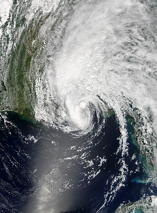
Tropical Storm Allison was a tropical storm that devastated southeast Texas in June of the 2001 Atlantic hurricane season. An arguable example of the "brown ocean effect", Allison lasted unusually long for a June storm, remaining tropical or subtropical for 16 days, most of which was when the storm was over land dumping torrential rainfall. The storm developed from a tropical wave in the northern Gulf of Mexico on June 4, 2001, and struck the upper Texas coast shortly thereafter. It drifted northward through the state, turned back to the south, and re-entered the Gulf of Mexico. The storm continued to the east-northeast, made landfall on Louisiana, then moved across the southeast United States and Mid-Atlantic. Allison was the first storm since Tropical Storm Frances in 1998 to strike the northern Texas coastline.

The 1995 Atlantic hurricane season was an extremely active Atlantic hurricane season and is considered to be the start of an ongoing era of high-activity tropical cyclone formation. The season produced twenty-one tropical cyclones, nineteen named storms, as well as eleven hurricanes and five major hurricanes. The season officially began on June 1 and ended on November 30, dates which conventionally delimit the period of each year when most tropical cyclones develop in the Atlantic basin. The first tropical cyclone, Hurricane Allison, developed on June 2, while the season's final storm, Hurricane Tanya, transitioned into an extratropical cyclone on November 1. The very active Atlantic hurricane activity in 1995 was caused by La Niña conditions, which also influenced a very inactive Pacific hurricane season.

Hurricane Michelle was the fifth costliest tropical cyclone in Cuban history and the strongest hurricane of the 2001 Atlantic hurricane season. The thirteenth named storm and seventh hurricane that year, Michelle developed from a tropical wave that had traversed into the western Caribbean Sea on October 29; the wave had initially moved off the coast of Africa 13 days prior. In its early developmental stages, the depression meandered over Nicaragua, later paralleling the Mosquito Coast before intensifying into tropical storm intensity on November 1; Michelle was upgraded to hurricane strength the following day. Shortly after, rapid intensification ensued within favorable conditions, with the storm's central barometric pressure dropping 51 mbar in 29 hours. After a slight fluctuation in strength, Michelle reached its peak intensity as a Category 4 hurricane with winds of 140 mph (230 km/h) and a minimum pressure of 933 mbar. This tied Michelle with 1999's Lenny as the fourth most powerful November hurricane on record in the Atlantic Basin, behind only the 1932 Cuba hurricane and 2020 Hurricanes Iota and Eta. At roughly the same time, the hurricane began to accelerate northeastward; this brought the intense hurricane to a Cuban landfall within the Bay of Pigs later that day. Crossing over the island, Michelle was weakened significantly, and was only a Category 1 hurricane upon reentry into the Atlantic Ocean. The hurricane later transitioned into an extratropical cyclone over The Bahamas on November 5, before being absorbed by a cold front the following day.

The 1968 Atlantic hurricane season was a below average hurricane season in which there were seven named storms. The season officially began on June 1 and lasted until November 30, dates which conventionally delimit the period of each year when most tropical cyclones form in the Atlantic basin. Of the named storms, five strengthened into hurricanes; none however intensified into a major hurricane. Only four other seasons since the start of the satellite era—1972, 1986, 1994, and 2013—did not feature a major hurricane. The first system, Hurricane Abby, developed in the northwestern Caribbean on June 1. Abby moved northward and struck Cuba, bringing heavy rainfall and flooding to western portions of the island. Making landfall in Florida on June 4, Abby caused flooding and spawned four tornadoes, but left behind little damage. Overall, the hurricane resulted in six deaths and about $450,000 (1968 USD) in damage. In late June, Tropical Storm Candy brought minor flooding and spawned several tornadoes across portions of the Southern United States. Overall damage from the cyclone reached approximately $2.7 million.

The 1992 Atlantic hurricane season was a significantly below average season in which only ten tropical or subtropical cyclones formed. Six became named tropical storms, of which four became hurricanes. Among the four was Hurricane Andrew, a major hurricane, and the costliest Atlantic hurricane on record at the time, surpassing Hugo of 1989. The season officially started on June 1 and officially ended on November 30. However, tropical cyclogenesis is possible at any time of the year, as demonstrated by formation in April of an unnamed subtropical storm in the central Atlantic. A June tropical depression caused flooding in Cuba and in Florida, where two people were killed. In August, Andrew struck the Bahamas, Florida, and Louisiana. In all, it caused $27.3 billion in damage, mostly in Florida, as well as 65 fatalities. The greatest impact was in South Florida, where the storm made landfall with 1-minute sustained winds of 175 mph (280 km/h).

The 1989 Atlantic hurricane season was an average hurricane season with 11 named storms. The season officially began on June 1, and ended on November 30. The first tropical cyclone, Tropical Depression One, developed on June 15, and dissipated two days later without any effects on land. Later that month, Tropical Storm Allison caused severe flooding, especially in Texas and Louisiana. Tropical Storm Barry, Tropical Depressions Six, Nine, and Thirteen, and Hurricanes Erin and Felix caused negligible impact. Hurricane Gabrielle and Tropical Storm Iris caused light effects on land, with the former resulting in nine fatalities from rip currents offshore the East Coast of the United States and Atlantic Canada, while the latter produced minor flooding in the United States Virgin Islands.

The 1991 Atlantic hurricane season was the first season since 1984 in which no hurricanes developed from tropical waves, which are the source for most North Atlantic tropical cyclones. The hurricane season officially began on June 1, and ended on November 30. It was the least active in four years due to higher than usual wind shear across the Atlantic Ocean. The first storm, Ana, developed on July 2 off the southeast United States and dissipated without causing significant effects. Two other tropical storms in the season – Danny and Erika – did not significantly affect land. Danny dissipated east of the Lesser Antilles, and Erika passed through the Azores before becoming extratropical. In addition, there were four non-developing tropical depressions. The second depression of the season struck Mexico with significant accompanying rains.

Hurricane Roxanne was a rare and erratic tropical cyclone that caused extensive flooding in Mexico, due to its unusual movement. The seventeenth storm, tenth hurricane, and the fifth and final major hurricane of the very active 1995 Atlantic hurricane season, Roxanne developed in the southwestern Caribbean Sea from an area of low pressure on October 7. The depression curved northward, causing it to avoid landfall in Central America. By October 9, the depression intensified enough to be upgraded to Tropical Storm Roxanne. On the following day, Roxanne turned west-northward, where it promptly intensified into a hurricane. As Roxanne headed generally westward, it began to rapidly deepen, and reached Category 3 intensity less than 24 hours after becoming a hurricane. Shortly thereafter, Roxanne made landfall near Cozumel, Mexico at its peak intensity, which caused severe damage.

Hurricane Jeanne was a Category 3 hurricane that struck the Caribbean and the Eastern United States in September 2004. It was the deadliest hurricane in the Atlantic basin since Mitch in 1998. It was the tenth named storm, the seventh hurricane, and the fifth major hurricane of the season, as well as the third hurricane and fourth named storm of the season to make landfall in Florida. After wreaking havoc on Hispaniola, Jeanne struggled to reorganize, eventually strengthening and performing a complete loop over the open Atlantic. It headed westwards, strengthening into a Category 3 hurricane and passing over the islands of Great Abaco and Grand Bahama in the Bahamas on September 25. Jeanne made landfall later in the day in Florida just two miles from where Hurricane Frances had struck a mere three weeks earlier.
Tropical Storm Arlene was an unusually large and early-forming tropical storm, being the first of twenty-eight different storms during the 2005 Atlantic hurricane season, which would become the second most active season on record. Tropical Storm Arlene formed near Honduras on June 8 and moved northwards. It crossed western Cuba on June 10 and strengthened to just under hurricane strength before making its final landfall on the Florida Panhandle the next day. The storm weakened as it continued to move north over the United States, becoming extratropical on June 13. Arlene was responsible for two deaths and minor damage.

Tropical Storm Alberto was the first tropical storm of the 2006 Atlantic hurricane season. Forming on June 10 in the northwestern Caribbean, the storm moved generally to the north, reaching a maximum intensity of 70 mph (110 km/h) before weakening and moving ashore in the Big Bend area of Florida on June 13. Alberto then moved through eastern Georgia, North Carolina, and Virginia as a tropical depression before becoming extratropical on June 14.

Hurricane Abby made landfall in Cuba, Florida, and North Carolina in June 1968. The first tropical cyclone, first named storm, and first hurricane on the season, Abby developed over the northwestern Caribbean Sea on June 1, as a result of the interaction between a mid-tropospheric trough and a cold front. Moving generally north-northeastward, the depression slowly strengthened while approaching the western tip of Cuba, becoming Tropical Storm Abby late on June 2. Shortly thereafter, Abby made landfall in Pinar del Río Province. The storm dropped heavy rainfall in western Cuba, with up to 12 inches (300 mm) on Isla de la Juventud. However, no flooding was reported. After reaching the southeastern Gulf of Mexico on June 3, Abby strengthened further and became a Category 1 hurricane on the modern-day Saffir–Simpson hurricane wind scale. However, early on June 4, Abby weakened to a tropical storm. Around midday on June 4, the system made landfall near Punta Gorda, Florida as a strong tropical storm.

Hurricane Alberto was a Category 1 hurricane that caused the worst flooding in western Cuba in 32 years. The first tropical storm and hurricane of the 1982 Atlantic hurricane season, Alberto developed from a tropical disturbance on June 2 in the southern Gulf of Mexico. It rapidly organized and attained hurricane status the following day, the earliest date for a hurricane in the Atlantic Ocean since Hurricane Alma in May 1970. Shortly after reaching peak winds off 85 mph (137 km/h), Alberto rapidly weakened due to approaching upper-level winds. Initial forecasts predicted the hurricane would continue northeastward into Florida; it turned sharply westward and drifted erratically for several days across the eastern Gulf of Mexico, before dissipating on June 6.
Tropical Storm Barry was a rapidly forming tropical cyclone that made landfall on Florida, United States, in early June 2007. The second named storm of the 2007 Atlantic hurricane season, Barry developed from a trough of low pressure in the southeastern Gulf of Mexico on June 1. It tracked rapidly northeastward, reaching peak winds of 60 mph (97 km/h) before weakening and making landfall near Tampa Bay as a tropical depression. Barry quickly lost tropical characteristics after wind shear removed much of the convection, and early on June 3, it completed the transition into an extratropical cyclone. The extratropical remnants tracked up the East Coast of the United States, and were absorbed by a larger extratropical cyclone on June 5.

Hurricane Gordon developed during a fourteen-day period along an erratic, persistent, and highly unusual path. The hurricane formed near Panama in the southwestern Caribbean on November 8, 1994. As a tropical depression, it brushed Nicaragua and spent several days in the waters off the country's coast. Strengthening slightly into a tropical storm, Gordon wound its way north into the Greater Antilles. Despite warm waters, persistent wind shear prevented significant strengthening. Executing a slow turn to the north and then the northwest, Gordon made two more landfalls, on eastern Jamaica and eastern Cuba, while delivering tremendous rains to western Hispaniola.

Tropical Storm Becky was the second tropical cyclone and named storm of the 1970 Atlantic hurricane season. Becky formed from a tropical depression that was designated on July 19. The next day it organized over the Yucatán Channel and became Tropical Storm Becky. Initially thought to have attained minimal hurricane status, Becky reached peak winds of 65 mph (100 km/h), but the storm began to deteriorate shortly thereafter. The storm made landfall on the Florida Panhandle on July 22, and rapidly weakened over land. Overall, damage was related to heavy rainfall that caused flooding in Tallahassee, Florida; 104 families suffered flood-related losses. About $500,000 in damage was attributed to the storm. Further north, the heavy rainfall swelled rivers. Becky may have been partially responsible for spawning tornadoes that destroyed or damaged several houses.

The 1994 Atlantic hurricane season was the final season in the most recent negative Atlantic multidecadal oscillation period of tropical cyclone formation within the basin. Despite the below average activity, the season was very deadly, with almost 97% of deaths occurring during Hurricane Gordon, a devastating late-season tropical cyclone that severely impacted the Caribbean Sea, the Greater Antilles and the United States, and one of the longest-lived Atlantic hurricanes on record at the time. The season produced seven named tropical cyclones and three hurricanes, a total below the seasonal average. The season officially started on June 1 and ended on November 30, dates which conventionally limit the period during which most tropical cyclones form in the Atlantic Ocean. The first tropical cyclone, Tropical Storm Alberto, developed on June 30, while the last storm, Hurricane Gordon, dissipated on November 21. The season was unusual in that it produced no major hurricanes, which are those of Category 3 status or higher on the Saffir–Simpson hurricane scale. The most intense hurricane, Hurricane Florence, peaked as a Category 2 storm with winds of 110 mph (180 km/h). Aside from Chris, Florence, and Gordon, none of the storms exceeded tropical storm intensity.

Tropical Storm Beryl was the strongest off-season Atlantic tropical cyclone on record to make landfall in the United States. The second tropical cyclone of the 2012 Atlantic hurricane season, Beryl developed on May 26 from a low-pressure system offshore North Carolina. Initially subtropical, the storm slowly acquired tropical characteristics as it tracked across warmer sea surface temperatures and within an environment of decreasing vertical wind shear. Late on May 27, Beryl transitioned into a tropical cyclone less than 120 miles (190 km) from North Florida. Early the following day, the storm moved ashore near Jacksonville Beach, Florida, with peak winds of 65 mph (100 km/h). It quickly weakened to a tropical depression, dropping heavy rainfall while moving slowly across the southeastern United States. A cold front turned Beryl to the northeast, and the storm became extratropical on May 30.

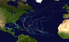
The 2020 Atlantic hurricane season was the most active Atlantic hurricane season on record, in terms of number of systems. It featured a total of 31 tropical or subtropical cyclones, with all but one cyclone became a named storm. Of the 30 named storms, 14 developed into hurricanes, and a record-tying seven further intensified into major hurricanes. It was the second and final season to use the Greek letter storm naming system, the first being 2005, the previous record. Of the 30 named storms, 11 of them made landfall in the contiguous United States, breaking the record of nine set in 1916. During the season, 27 tropical storms established a new record for earliest formation date by storm number. This season also featured a record 10 tropical cyclones that underwent rapid intensification, tying it with 1995, as well as tying the record for most Category 4 hurricanes in a singular season in the Atlantic Basin. This unprecedented activity was fueled by a La Niña that developed in the summer months of 2020 as it did, continue a stretch of above-average seasonal activity that began in 2016. Despite the record-high activity, this was the first season since 2015 in which no Category 5 hurricane formed.

Tropical Storm Alberto was a damaging pre-season tropical cyclone that caused $125 million in damage to the Gulf Coast of the United States in late May 2018, the costliest for any pre-season tropical cyclone. The first storm of the 2018 Atlantic hurricane season, Alberto developed on May 25 near the Yucatán Peninsula as a subtropical cyclone. As it entered the Gulf of Mexico, Alberto intensified and transitioned into a tropical cyclone. Early on May 28, Alberto reached its peak intensity, with maximum sustained winds of 65 mph (100 km/h) and a minimum pressure of 990 mbar. Afterward, however, dry air caused Alberto to weaken before it made landfall near Laguna Beach, Florida, with winds of 45 mph (75 km/h). Alberto maintained a compact area of thunderstorms as it progressed through the central United States, entering southern Michigan as a tropical depression on May 31. That day, Alberto weakened further and dissipated over Ontario.


