Huskisson Parish, New Brunswick

Last updated

Huskisson
Kent County NB - Huskisson Parish.PNG
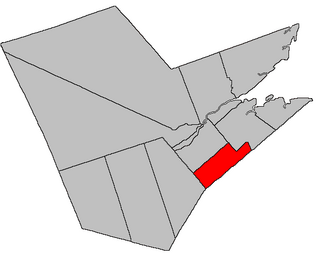
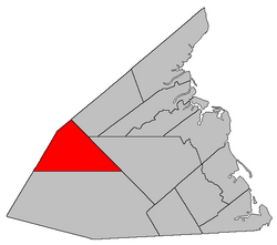
Location within Kent County, New Brunswick.
Coordinates: 46°31′30″N65°27′54″W / 46.525°N 65.465°W / 46.525; -65.465
Country Flag of Canada (Pantone).svg  Canada
Province Flag of New Brunswick.svg  New Brunswick
County Kent County
Erected1827
Area
[1]
  Land369.31 km2 (142.59 sq mi)
Population
 (2021) [1]
  Total5
  Density0.0/km2 (0/sq mi)
  Change 2016-2021
Decrease2.svg 66.7%
  Dwellings (2021)
8
Time zone UTC-4 (AST)
  Summer (DST) UTC-3 (ADT)

Huskisson is a geographic parish in Kent County, New Brunswick, Canada. [4]

Contents

For governance purposes the northern part of the parish is within the village of Five Rivers [5] while most belongs to the Kent rural district; [6] both are members of the Kent Regional Service Commission. [7]

Prior to the 2023 governance reform, the parish was part of the local service district of the parish of Harcourt. [lower-alpha 1] References to an LSD of Huskisson on provincial governance reforms maps are erroneous.

Origin of name

The parish was named in honour of William Huskisson, President of the Board of Trade at the time of its erection [9] and one of the plenipotentiaries of boundary negotiations with the United States in 1826. [10]

Addington Parish was named at the same time for the other British plenipotentiary, Henry Unwin Addington.

History

In 1827 Huskisson was erected from unassigned territory north of the Richibucto River, [11] comprising a shallower area than it has today.

In 1850 the southern boundary was altered to run due west from its starting point. [12] to include an area annexed by the county in 1845. [13]

Boundaries

Huskisson Parish is bounded: [2] [14] [15] [16]

Communities

Communities at least partly within the parish; [14] [15] [16]

Bodies of water

Bodies of water [lower-alpha 3] at least partly in the parish: [14] [15] [16]

Demographics

See also

Notes

  1. Although the provincial regulation [8] named only Harcourt Parish, zoning maps released by the Kent RSC showed that Huskisson Parish was part of the Harcourt Parish LSD, reflecting historic inclusion of Huskisson Parish for statistical purposes.
  2. Magnetic declination at the time was about 21º west. [17]
  3. Not including brooks, ponds or coves.

Related Research Articles

<span class="mw-page-title-main">Beresford Parish, New Brunswick</span> Parish in New Brunswick, Canada

Beresford is a geographic parish in Gloucester County, New Brunswick, Canada.

<span class="mw-page-title-main">Dundas Parish, New Brunswick</span> Parish in Canada

Dundas is a geographic parish in Kent County, New Brunswick, Canada.

<span class="mw-page-title-main">Richibucto Parish, New Brunswick</span> Parish in New Brunswick, Canada

Richibucto is a geographic parish in Kent County, New Brunswick, Canada.

<span class="mw-page-title-main">Addington Parish, New Brunswick</span> Parish in New Brunswick, Canada

Addington is a geographic parish in Restigouche County, New Brunswick, Canada.

<span class="mw-page-title-main">Acadieville Parish, New Brunswick</span> Parish in New Brunswick, Canada

Acadieville is a geographic parish in Kent County, New Brunswick, Canada.

<span class="mw-page-title-main">Blissfield Parish, New Brunswick</span> Parish in New Brunswick, Canada

Blissfield is a geographic parish in Northumberland County, New Brunswick, Canada.

<span class="mw-page-title-main">Hardwicke Parish, New Brunswick</span> Parish in New Brunswick, Canada

Hardwicke is a geographic parish in Northumberland County, New Brunswick, Canada.

<span class="mw-page-title-main">Ludlow Parish, New Brunswick</span> Parish in New Brunswick, Canada

Ludlow is a geographic parish in Northumberland County, New Brunswick, Canada.

<span class="mw-page-title-main">Nelson Parish, New Brunswick</span> Parish in New Brunswick, Canada

Nelson is a geographic parish in Northumberland County, New Brunswick, Canada.

<span class="mw-page-title-main">Rogersville Parish, New Brunswick</span> Parish in New Brunswick, Canada

Rogersville is a geographic parish in Northumberland County, New Brunswick, Canada.

<span class="mw-page-title-main">Blackville Parish, New Brunswick</span> Parish in New Brunswick, Canada

Blackville is a geographic parish in Northumberland County, New Brunswick, Canada.

<span class="mw-page-title-main">Carleton Parish, New Brunswick</span> Parish in New Brunswick, Canada

Carleton is a geographic parish in Kent County, New Brunswick, Canada.

<span class="mw-page-title-main">Saint-Charles Parish, New Brunswick</span> Parish in New Brunswick, Canada

Saint-Charles is a geographic parish in Kent County, New Brunswick, Canada.

<span class="mw-page-title-main">Wellington Parish, New Brunswick</span> Parish in New Brunswick, Canada

Wellington is a geographic parish in Kent County, New Brunswick, Canada.

<span class="mw-page-title-main">Sainte-Marie Parish, New Brunswick</span> Parish in New Brunswick, Canada

Saint-Marie, is a geographic parish in Kent County, New Brunswick, Canada.

<span class="mw-page-title-main">Weldford Parish, New Brunswick</span> Parish in New Brunswick, Canada

Weldford is a geographic parish in Kent County, New Brunswick, Canada.

<span class="mw-page-title-main">Harcourt Parish, New Brunswick</span> Parish in New Brunswick, Canada

Harcourt is a geographic parish in Kent County, New Brunswick, Canada.

<span class="mw-page-title-main">Kent Parish, New Brunswick</span> Parish in New Brunswick, Canada

Kent is a geographic parish in the northeastern corner of Carleton County, New Brunswick, Canada.

<span class="mw-page-title-main">Northfield Parish, New Brunswick</span> Parish in New Brunswick, Canada

Northfield is a geographic parish in Sunbury County, New Brunswick, Canada.

<span class="mw-page-title-main">Brunswick Parish, New Brunswick</span> Parish in New Brunswick, Canada

Brunswick is a geographic parish in the northeastern corner of Queens County, New Brunswick, Canada.

References

  1. 1 2 "Census Profile". Statistics Canada. 26 October 2022. Retrieved 29 October 2022.
  2. 1 2 "Chapter T-3 Territorial Division Act". Government of New Brunswick. Retrieved 26 February 2023.
  3. "Chapter I-13 Interpretation Act". Government of New Brunswick. Retrieved 26 February 2023.
  4. The Territorial Division Act [2] divides the province into 152 parishes, the cities of Saint John and Fredericton, and one town of Grand Falls. The Interpretation Act [3] clarifies that parishes include any local government within their borders.
  5. "Kent Regional Service Commission: RSC 6". Government of New Brunswick. Retrieved 26 February 2023.
  6. "Kent Regional Service Commission: RD 6". Government of New Brunswick. Retrieved 26 February 2023.
  7. "Regions Regulation – Regional Service Delivery Act". Government of New Brunswick. 21 July 2022. Retrieved 26 February 2023.
  8. "Local Service Districts Regulation - Municipalities Act". Government of New Brunswick. 25 June 2021. Retrieved 26 February 2023.
  9. Ganong, William F. (1896). A Monograph of the Place-Nomenclature of the Province of New Brunswick. Royal Society of Canada. p. 241. Retrieved 17 March 2021.
  10. Ganong, William F. (1906). Additions and Corrections to Monographs on the Place-Nomenclature, Cartography, Historic Sites, Boundaries and Settlement-origins of the Province of New Brunswick. Royal Society of Canada. p. 27. Retrieved 12 April 2021.
  11. "7 Geo. IV c. 31 An Act for the division of the County of Northumberland into three Counties, and to provide for the Government and Representation of the two new Counties.". Acts of the General Assembly of His Majesty's Province of New-Brunswick, Passed in the Year 1827. Fredericton: Government of New Brunswick. 1827. pp. 97–103. Retrieved 27 March 2021.
  12. "13 Vic. c. 51 An Act to consolidate all the Laws now in force for the division of the Province into Counties, Towns and Parishes.". Acts of the General Assembly of Her Mjaesty's Province of New Brunswick, Passed in the Year 1850. Fredericton: Government of New Brunswick. 1850. pp. 142–152, 145–149. Retrieved 27 March 2021. Book was poorly proofread, resulting in title typo and reuse of page numbers 145–152.
  13. "8 Vic. c. 80 An Act to extend the Division Line between the Counties of Northumberland and Kent to the rear Line of the Counties of Queen's County and Sunbury.". Acts of the General Assembly of Her Majesty's Province of New Brunswick, Passed in the Year 1845. Fredericton: Government of New Brunswick. 1845. p. 58. Retrieved 27 March 2021.
  14. 1 2 3 "No. 78". Provincial Archives of New Brunswick. Department of Natural Resources and Energy Development. Retrieved 11 June 2021. Remainder of parish on maps 87, 88, 97, and 98 at same site.
  15. 1 2 3 "249" (PDF). Transportation and Infrastructure. Government of New Brunswick. Retrieved 11 June 2021. Remainder of parish on mapbooks 250, 265–267, and 281–283 at same site.
  16. 1 2 3 "Search the Canadian Geographical Names Database (CGNDB)". Government of Canada. Retrieved 11 June 2021.
  17. "Historical Magnetic Declination". National Oceanic and Atmospheric Administration. Retrieved 20 February 2021.
  18. Statistics Canada: 1996, 2001, 2006 census
  19. 2011 Statistics Canada Census Profile: Huskisson Parish, New Brunswick
  20. "Census Profile, 2016 Census: Huskisson, Parish [Census subdivision], New Brunswick". Statistics Canada. Retrieved 27 August 2019.
  21. 2006 Statistics Canada Community Profile: Huskisson Parish, New Brunswick


46°31′30″N65°27′54″W / 46.52500°N 65.46500°W / 46.52500; -65.46500 (Huskisson Parish, New Brunswick)