![]() EF3 damage to brick businesses in Marshaltown, Iowa. | |
Type | Tornado outbreak |
---|---|
Formed | July 19, 2018 |
Dissipated | July 20, 2018 |
Highest winds |
|
Tornadoes confirmed | 32 |
Max. rating1 | EF3 tornado |
Duration of tornado outbreak2 | 33 hours, 14 minutes |
Fatalities | 0 (+17 non-tornadic), 37 injuries |
Damage | $321.385 million (2018 USD) [3] |
Areas affected | Midwestern United States |
Part of the Tornadoes of 2018 1Most severe tornado damage; see Fujita scale 2Time from first tornado to last tornado |
On July 19 and 20, 2018, an unexpected strong tornado outbreak affected Iowa and nearby areas. The event was triggered mostly by three supercells that produced several tornadoes across southeastern Iowa east and southeast of Des Moines. Two of the tornadoes reached EF3 intensity, affecting Pella and Marshalltown. These were the strongest tornadoes to hit Iowa since June 22, 2015, when another EF3 tornado struck near Lovilia. Of the 37 injuries, 13 occurred in Pella, and 23 in Marshalltown, and one the following day in Indiana. The event was also notable due to the Table Rock Lake duck boat accident that killed 17 people and injured 7 others at Table Rock Lake, Missouri.
The tornado outbreak as well as the other the severe weather that day was either poorly forecasted or essentially unforecasted; the outlook from the Storm Prediction Center that day had much of eastern Iowa under a 2% risk area for tornadoes. This was due to an inaccurate analysis of a closed low over the northern part of the state . At the time, the low was analyzed as being closed at the 500 mb level. However, reanalysis of the event revealed that the low was closed at only 700 mb. As the event began, several weak supercells formed over central Iowa and moved eastward, producing multiple weak tornadoes. However, one supercell produced two simultaneous EF2 tornadoes in Bondurant. Shortly afterwards, a tornado watch was issued for the region from 3:10–10 pm CDT. However, a significant tornado outbreak was still not expected as the threat for tornadoes was only increased to 5% at the 20:00 UTC outlook, indicating the threat of only a couple of tornadoes. At 21:00 UTC on July 19 (4 pm CDT), a large Storm-Relative Helicity (SRH) and low level wind shear was reported across the region. The dewpoints were also in the 70s°F (20s°C), which is moist for this type of event. [4] Around this time, the southern-most storm evolved into a large tornadic supercell and moved southeastward, producing several tornadoes, including an EF3 tornado that passed near Pella. The Bondurant supercell, then weakened, but another strong supercell developed to its north and absorbed it as it moved eastward. Fueled by an interaction with an outflow boundary from the southern supercell, the storm produced a large, wedge EF3 tornado that directly struck the town of Marshalltown. Afterwards, the northern supercell and the storms north of it weakened, but the southern supercell continued southeastward and eventually transitioned into a small squall line.
As the system trekked eastwards into July 20, damaging winds and hail became the main threat, with a 30% chance of strong wind across much of Arkansas, Tennessee and Kentucky, and a 45% chance of damaging hail across central Tennessee and Kentucky. However, a 10% tornado risk was also issued for western Tennessee and eastern Kentucky, with the threat of tornadoes stretching from western Arkansas to southern Michigan. An EF1 tornado in Indiana caused an injury to a camper, who was flipped over. [5] However, that was the only casualty, as no tornadoes that day were stronger than EF1 intensity.
EFU | EF0 | EF1 | EF2 | EF3 | EF4 | EF5 | Total |
---|---|---|---|---|---|---|---|
1 | 16 | 6 | 2 | 2 | 0 | 0 | 32 |
EF# | Location | County / Parish | State | Start Coord. | Time (UTC) | Path length | Max width | Summary |
---|---|---|---|---|---|---|---|---|
EF0 | WNW of Ceylon | Martin | MN | 43°32′N94°40′W / 43.54°N 94.67°W | 17:45–17:56 | 0.21 mi (0.34 km) | 10 yd (9.1 m) | A tornado was reported in the area with trees downed. [6] |
EF0 | S of Clarion (1st tornado) | Wright | IA | 42°38′45″N93°47′47″W / 42.6457°N 93.7965°W | 19:30–19:37 | 3.5 mi (5.6 km) | 80 yd (73 m) | A tornado damaged crops. [7] |
EF0 | S of Clarion (2nd tornado) | Wright | IA | 42°34′45″N93°46′44″W / 42.5791°N 93.7789°W | 19:35–19:47 | 4.43 mi (7.13 km) | 80 yd (73 m) | A tornado was photographed to the south of Clarion. Only crop damage occurred. [8] |
EF0 | NE of Woolstock | Wright | IA | 42°34′50″N93°42′46″W / 42.5806°N 93.7128°W | 19:42–19:45 | 1.28 mi (2.06 km) | 60 yd (55 m) | High-resolution satellite imagery confirmed a tornado over agricultural areas. [9] |
EF0 | Northeastern Ankeny | Polk | IA | 41°44′22″N93°34′24″W / 41.7394°N 93.5732°W | 19:48–19:49 | 0.88 mi (1.42 km) | 50 yd (46 m) | Several trees, fencing, and pieces of playground equipment were damaged by this weak tornado. [10] |
EF2 | N of Bondurant | Polk | IA | 41°43′29″N93°29′42″W / 41.7246°N 93.4951°W | 19:50–20:02 | 3.68 mi (5.92 km) | 130 yd (120 m) | This low-end EF2 tornado occurred simultaneously with the tornado below. A well-built metal outbuilding had most of its roof removed and sustained collapse of two walls. Numerous trees were snapped or uprooted, and severe crop damage occurred along the path. [11] |
EF2 | Bondurant | Polk | IA | 41°42′03″N93°30′13″W / 41.7008°N 93.5037°W | 19:51–20:00 | 2.95 mi (4.75 km) | 100 yd (91 m) | A low-end EF2 tornado moved through residential areas in Bondurant. One home had its second story blown off, a few homes had major roof damage, and other homes sustained less severe damage. An unanchored detached garage was swept away, and vehicles were overturned as well. [12] |
EF0 | W of Story City | Story | IA | 42°10′22″N93°39′33″W / 42.1727°N 93.6592°W | 19:52–19:57 | 2.07 mi (3.33 km) | 40 yd (37 m) | This rope tornado remained over open country, causing only crop damage. [13] |
EF0 | N of Blairsburg | Hamilton | IA | 42°29′19″N93°39′22″W / 42.4887°N 93.656°W | 19:56–20:05 | 2.67 mi (4.30 km) | 60 yd (55 m) | A weak tornado north of Blairsburg damaged crops. [14] |
EF0 | NW of Prairie City | Jasper | IA | 41°37′45″N93°20′02″W / 41.6293°N 93.334°W | 20:18–20:24 | 2.35 mi (3.78 km) | 60 yd (55 m) | This was the first tornado produced by the Pella supercell. It remained over open farm fields, causing no damage. [15] |
EF0 | NE of Roland | Story | IA | 42°10′44″N93°29′08″W / 42.1789°N 93.4856°W | 20:22–20:30 | 2.79 mi (4.49 km) | 60 yd (55 m) | High-resolution satellite imagery confirmed a tornado with damage to crops. [16] |
EF0 | SE of Prairie City | Jasper | IA | 41°34′23″N93°13′07″W / 41.573°N 93.2186°W | 20:28–20:34 | 2.62 mi (4.22 km) | 80 yd (73 m) | This was the second tornado produced by the Pella supercell. Crops and trees were damaged along the path. [17] |
EF0 | NE of Collins | Story | IA | 41°55′13″N93°18′01″W / 41.9202°N 93.3002°W | 20:35–20:40 | 2.48 mi (3.99 km) | 40 yd (37 m) | High-resolution satellite imagery confirmed a tornado with damage to crops. [18] |
EF1 | E of Monroe | Jasper, Marion | IA | 41°31′43″N93°03′51″W / 41.5286°N 93.0643°W | 20:45–20:52 | 3.96 mi (6.37 km) | 500 yd (460 m) | This was the third tornado produced by the Pella supercell. A machine shed lost a small part of its roof, and trees and crops were damaged. [19] [20] |
EF0 | E of Otley | Marion | IA | 41°28′31″N92°58′48″W / 41.4752°N 92.9801°W | 20:56–20:58 | 0.99 mi (1.59 km) | 40 yd (37 m) | A brief tornado caused little to no damage. [21] |
EF3 | Eastern Pella | Marion | IA | 41°27′37″N92°56′14″W / 41.4602°N 92.9371°W | 21:01–21:24 | 9.17 mi (14.76 km) | 800 yd (730 m) | The fourth produced by the Pella supercell, this large cone tornado clipped the eastern edge of Pella, causing major structural damage to large factory buildings at the Vermeer plant complex. Reinforced masonry exterior walls were bowed in and collapsed at this location, metal support beams were severely bent, and large amounts of roofing was peeled from the buildings and scattered. Numerous vehicles, semi-trailers, and pieces of machinery were thrown and mangled at the plant, some of which were found piled atop each other and wrapped in sheet metal. Outside of town, barns were destroyed and a wide swath of corn was flattened in farm fields. A two-story farm home was shifted off of its foundation, and an addition to the south side of the house was destroyed. A few other homes sustained less severe damage. Thirteen people were injured. [22] [23] |
EF0 | E of Clemons | Marshall | IA | 42°06′16″N93°08′00″W / 42.1045°N 93.1332°W | 21:11–21:13 | 0.85 mi (1.37 km) | 40 yd (37 m) | High-resolution satellite imagery confirmed a tornado with damage to crops. The same storm produced the EF3 Marshalltown tornado. [24] |
EF0 | NE of Pella | Mahaska | IA | 41°25′08″N92°51′26″W / 41.4188°N 92.8571°W | 21:15–21:18 | 1.16 mi (1.87 km) | 60 yd (55 m) | A satellite tornado to the Pella EF3 tornado damaged crops. This was the fifth tornado produced by the Pella supercell. [25] |
EF3 | Marshalltown | Marshall | IA | 42°04′58″N93°01′39″W / 42.0829°N 93.0275°W | 21:24–21:47 | 8.41 mi (13.53 km) | 1,200 yd (1,100 m) | A large and intense multiple-vortex wedge tornado moved directly through downtown Marshalltown, prompting the issuance of a tornado emergency and causing widespread major damage. Numerous brick businesses in the downtown area were severely damaged, some of which sustained total destruction of their upper floors. Streets in this area were littered with bricks and structural debris, and the Marshall County Courthouse had the top portion of its clock tower ripped off. A large office building had much of its facade ripped off, and sustained loss of exterior walls on multiple floors. Homes in residential areas of town were heavily damaged and a few were destroyed, along with numerous vehicles and detached garages. A Lennox International plant had significant roof loss and collapse of multiple reinforced exterior walls, with many cars tossed and damaged in the parking lot. Numerous trees, light poles, signs, and power poles were downed throughout the town as well. Twenty-three people were injured. [26] |
EF0 | S of Oskaloosa | Mahaska | IA | 41°13′43″N92°36′37″W / 41.2285°N 92.6102°W | 21:50–21:53 | 1.24 mi (2.00 km) | 60 yd (55 m) | High-resolution satellite imagery confirmed a tornado with damage to crops. This was the sixth tornado produced by the Pella supercell. [27] |
EF1 | NNE of Keosauqua (1st tornado) | Van Buren | IA | 40°48′11″N91°58′12″W / 40.803°N 91.9699°W | 23:07–23:15 | 2.14 mi (3.44 km) | 50 yd (46 m) | A large historic stone barn was destroyed. Trees, a corn field, and a small farm outbuilding were damaged. This was the seventh tornado produced by the Pella supercell. [28] |
EF1 | NNE of Keosauqua (2nd tornado) | Van Buren | IA | 40°44′54″N91°57′24″W / 40.7482°N 91.9567°W | 23:09–23:11 | 0.19 mi (0.31 km) | 75 yd (69 m) | Several large farm outbuildings and equipment were destroyed. Corn crops were damaged. This was the final tornado produced by the Pella supercell. [29] |
EF# | Location | County / Parish | State | Start Coord. | Time (UTC) | Path length | Max width | Summary |
---|---|---|---|---|---|---|---|---|
EF0 | NW of Camdenton | Camden | MO | 38°04′N92°52′W / 38.07°N 92.87°W | 09:32–09:33 | 0.12 mi (0.19 km) | 75 yd (69 m) | Numerous trees were uprooted and tree limbs were snapped. Power lines were downed as well. [30] |
EF0 | SW of Bremen | Marshall | IN | 41°22′56″N86°13′11″W / 41.3823°N 86.2197°W | 17:53–17:55 | 0.5 mi (0.80 km) | 50 yd (46 m) | A barn sustained damage to its cinder block exterior wall, corn was flattened, and some tree branches were broken. [31] |
EF0 | WNW of Wautoma | Waushara | WI | 44°03′45″N89°15′06″W / 44.0624°N 89.2517°W | 17:55–17:56 | 0.08 mi (0.13 km) | 10 yd (9.1 m) | A small tornado snapped branches off of several pine trees and tossed them into the air. [32] |
EF0 | N of Salem | Washington | IN | 38°38′01″N86°06′34″W / 38.6336°N 86.1095°W | 18:03–18:05 | 1.1 mi (1.8 km) | 75 yd (69 m) | A weak and intermittent tornado downed a few tree limbs and small fences. Multiple metal roof panels were ripped from a barn, while its overhead garage doors were blown in and the entrance door was ripped off. A house sustained considerable damage to its siding and roof, a small play shed was destroyed, and corn was flattened in a field. [33] |
EF1 | S of Corydon | Harrison | IN | 38°09′10″N86°09′00″W / 38.1527°N 86.1501°W | 18:04–18:20 | 6 mi (9.7 km) | 250 yd (230 m) | A multiple-vortex tornado impaled a wooden two-by-eight plank into a concrete grain silo, extensively damaged four large barns, and caused significant tree damage. One tree fell on a garage, several homes sustained substantial roof damage, a pole barn was completely destroyed, and a truck and horse trailer was twisted and moved 50 ft (15 m). Corn crops were flattened, a camper was tossed and flipped over, and single-wide trailers were flipped over as well. [34] |
EF0 | N of La Fontaine | Wabash | IN | 40°43′41″N85°43′05″W / 40.7281°N 85.7180°W | 19:14–19:15 | 0.8 mi (1.3 km) | 25 yd (23 m) | A brief tornado ripped the roof from an outbuilding and snapped or uprooted trees. [35] |
EF1 | Moonville | Madison | IN | 40°11′43″N85°36′41″W / 40.1954°N 85.6115°W | 19:50–19:52 | 0.6 mi (0.97 km) | 30 yd (27 m) | A barn was destroyed, a storage shed was flipped onto its side, and trees in town were damaged. [36] |
EF0 | ESE of Sweetwater | Miami-Dade | FL | 25°45′39″N80°21′44″W / 25.7608°N 80.3623°W | 20:22–20:24 | 0.19 mi (0.31 km) | 20 yd (18 m) | Trees, mailboxes, street signs, canopies, and basketball hoops all sustained minor damage from a brief tornado that eventually became a waterspout over a large retention pond before lifting. [37] |
EF0 | SE of Edmonton | Metcalfe | KY | 36°57′41″N85°35′35″W / 36.9614°N 85.5931°W | 23:03–23:05 | 2.1 mi (3.4 km) | 60 yd (55 m) | A carport was overturned and two metal outbuildings lost roofing material. A double-wide mobile home was shifted off its foundation, with its windows broken and shingles ripped from the roof. Numerous trees were snapped. [38] |
EF1 | NE of Priceville | Hart | KY | 37°23′24″N85°56′39″W / 37.39°N 85.9443°W | 02:56–02:59 | 1.2 mi (1.9 km) | 60 yd (55 m) | A large barn and several large hay bales were destroyed. Numerous trees were snapped along the path. [39] |
As part of the storm system as a whole, a duck boat tour sank in Table Rock Lake, Missouri, at approximately 7 pm CDT. Of the 31 people on board, 17 of them died and 7 were injured. Nine of them were in a single family. Wind gusts were reportedly in excess of 60 miles per hour (97 km/h). [40] A wind gust in Branson, Missouri reached 74 miles per hour (119 km/h). [41]
Pella had 14,000 power outages while Bondurant, which got hit by an EF2 tornado, had 1,800 outages. [42] Despite the damage and injuries, though, no one died due to tornadoes, which is likely credited to timely warnings once the tornadoes actually did touch down. [43] Following these tornadoes, several counties in Iowa were declared disaster zones by Kim Reynolds. [44] Marsalltown would suffer even more destruction just over two years later when a powerful derecho produced widespread destruction across the city. Several buildings in downtown Marshalltown were condemned and demolished in the following years as a result of both storms. [45]
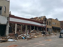
An unseasonably strong tornado outbreak began on January 7, 2008, and continued for nearly four days across the Central and Southern United States, with the hardest hit area being southwestern Missouri, northwestern Arkansas, and the surrounding area. In addition, a strong supercell in northern Illinois and southeastern Wisconsin produced that region's first January tornadoes since 1967.
A satellite tornado is a tornado that revolves around a larger, primary tornado and interacts with the same mesocyclone. Satellite tornadoes occur apart from the primary tornado and are not considered subvortices; the primary tornado and satellite tornadoes are considered to be separate tornadoes. The cause of satellite tornadoes is not known. Such tornadoes are more often anticyclonic than are typical tornadoes and these pairs may be referred to as tornado couplets. Satellite tornadoes commonly occur in association with very powerful, large, and destructive tornadoes, indicative also of the strength and severity of the parent supercell thunderstorm.
A destructive and deadly tornado outbreak that took place across the Southern and Central United States from May 1 to May 3, 2008. The outbreak was responsible for at least seven fatalities and 23 injuries in Arkansas. There were at least 29 tornado reports from Iowa to Oklahoma on May 1 and 67 more in Arkansas, Missouri, Mississippi, Tennessee, Louisiana and Texas on May 2. A total of 60 tornadoes were confirmed by weather authorities.
An unusually prolific and very destructive late-winter tornado outbreak resulted in significant damage and numerous casualties across the southern and eastern half of the United States between February 23–24, 2016. Lasting over a day and a half, the outbreak produced a total of 61 tornadoes across eleven states, which ranked it as one of the largest February tornado outbreaks in the United States on record, with only the 2008 Super Tuesday tornado outbreak having recorded more. In addition, it was also one of the largest winter tornado outbreaks overall as well. The most significant and intense tornadoes of the event were four EF3 tornadoes that struck southeastern Louisiana, Pensacola, Florida, Evergreen, Virginia, and Tappahannock, Virginia. Tornadoes were also reported in other places like Texas, Florida, and Pennsylvania. Severe thunderstorms, hail and gusty winds were also felt in the Northeastern United States and Mid-Atlantic states on February 24 as well.
A six-hour tornado outbreak of 24 tornadoes impacted Indiana, Ohio, and Ontario on August 24, 2016. Several of these tornadoes were strong and caused significant damage, including a high-end EF2 tornado that struck Windsor, Ontario, Canada and an EF3 tornado that struck Kokomo, Indiana. This particular tornado outbreak was unusual for multiple reasons, including the fact that it was largely unexpected. The Storm Prediction Center had issued only a slight risk for severe weather that day, with the threat for a tornado or two limited to parts of Kansas, Missouri, Iowa, and Illinois. Despite this, the outbreak unfolded entirely outside of the outlined threat area as numerous supercell thunderstorms developed unexpectedly across parts of the Great Lakes and Ohio Valley, producing numerous tornadoes. Tornado outbreaks of this size and intensity are also not commonly seen during the late summer months across the Ohio Valley region. Despite the damage, no fatalities occurred.
A deadly tornado outbreak severely impacted the Southern United States, and also affected Iowa and Nebraska to a lesser extent, between November 27–30, 2016. The strongest tornadoes of the event affected Alabama and Tennessee during the late evening of November 29 and into the early morning hours of November 30. Overall, this outbreak produced 48 tornadoes, killed six people, and injured many others.
The tornado outbreak of February 28 – March 1, 2017 was a widespread and significant outbreak of tornadoes and severe weather that affected the Midwestern United States at the end of February 2017 and beginning of March. Fueled by the combination of ample instability, strong wind shear, and rich low-level moisture, the event led to 71 confirmed tornadoes and thousands of other non-tornadic severe weather reports. The most notable aspect of the outbreak was a long-tracked EF4 tornado—the first violent tornado of 2017 and the first violent tornado during the month of February since the 2013 Hattiesburg, Mississippi tornado—that tracked from Perryville, Missouri to near Christopher, Illinois, killing one person. Three EF3 tornadoes were recorded during the event, including one that caused two fatalities in Ottawa, Illinois, one that caused a fatality near Crossville, and one that heavily damaged or destroyed homes in and around Washburn. In addition to the deaths, 38 people were injured by tornadoes and an additional 30 were injured by non-tornadic impacts, mainly by fallen trees.
The tornado outbreak of March 6–7, 2017 was a widespread severe weather and tornado outbreak that affected portions of the Midwestern United States in the overnight hours of March 6–7. Occurring just days after a deadly and more significant event across similar areas just a week prior, this particular outbreak led to 63 tornadoes within a 91⁄2-hour period as a quasi-linear convective system and discrete supercell thunderstorms traversed the region. The most notable aspect of the outbreak was an EF3 tornado that damaged or destroyed hundreds of structures within Oak Grove, Missouri, injuring 12 people but causing no fatalities. An EF1 tornado touched down near Bricelyn, the earliest known tornado on record in the state of Minnesota. Outside of tornadic activity, hundreds of damaging wind reports and a multitude of severe hail reports were documented.
A prolonged period of intense tornado activity affected the Great Plains, Great Lakes, and Ohio Valley during May 15–20, 2017. This outbreak sequence was the most prolific tornado event of 2017 in terms of number of tornadoes. It is also notable for producing the longest-tracked tornado in Wisconsin state history: an intense EF3 tornado that remained on the ground for over 82 miles (132 km) and killed one person while causing major damage near Chetek and Conrath. Overall, the outbreak sequence resulted in two deaths and several injuries.
The April 2018 North American storm complex brought a wide swath of severe and winter weather that affected much of Midwest across to the East Coast of the United States. This particular outbreak led to at least 73 confirmed tornadoes over a three-day period, most of which occurred across Arkansas and Louisiana during the evening hours of April 13. The most significant tornadoes were an EF1 that caused a fatality in Red Chute, Louisiana, early on April 14, an upper-end EF2 tornado that impacted eastern sections of Greensboro, North Carolina on April 15, causing 17 injuries, and a significant EF3 tornado that impacted areas from Lynchburg to Elon, Virginia, causing severe damage and at least 10 injuries.
A destructive, two-day tornado outbreak affected the Great Lakes region of the United States and the National Capital Region of Canada in late-September. A total of 37 tornadoes were confirmed, including a violent long-tracked high-end EF3 tornado that moved along a 80 km (50 mi) path from near Dunrobin, Ontario to Gatineau, Quebec, and an EF2 tornado in the Nepean sector of Ottawa. The tornadoes in Ottawa-Gatineau were declared one of the ten most significant weather events of 2018 in Canada by the Meteorological Service of Canada.
The tornado outbreak of November 30 – December 2, 2018 was a late-season tornado outbreak that occurred across portions of the West South Central states and Midwestern United States. As a potent shortwave trough moved across the southern portions of the country, it was met with ample moisture return and destabilization, resulting in widespread severe thunderstorms that produced damaging winds, hail, and tornadoes. The event began late on November 30 in Oklahoma, spreading east and resulting in one fatality in Aurora, Missouri. Several tornadic supercells moved across portions of Illinois on December 1, and resulted in 29 confirmed tornadoes. This outbreak was the largest December tornado event on record in Illinois history, surpassing the December 1957 tornado outbreak sequence. The most significant tornado of the event was an EF3 that impacted Taylorville, Illinois, damaging or destroying hundreds of structures and injuring 22 people.
A significant severe weather and tornado outbreak affected multiple regions of the Eastern United States in mid-April 2019. Over the course of 40 hours, 75 tornadoes touched down. The outbreak produced numerous strong tornadoes throughout portions of the Deep South, while additional significant tornadoes occurred as far north as Ohio, Pennsylvania, and Delaware. The most significant tornado of the event was a long-tracked, high-end EF3 tornado that struck Alto, Texas and killed two people. Numerous weak tornadoes were also confirmed, along with numerous reports of hail and damaging straight line winds.
A significant severe weather event impacted the South Central United States between October 20–22, 2019. Forecasters first identified the threat on October 16 as a large upper-level trough was expected to combine with an unstable atmosphere across Texas, Oklahoma, and Arkansas particularly. On the evening of October 20, discrete supercell thunderstorms developed across the Dallas–Fort Worth metroplex, contributing to several tornadoes. One of those tornadoes caused EF3 damage in the Dallas suburbs, becoming the costliest tornado event in Texas history, at $1.55 billion. A later squall line contributed to additional tornadoes and a widespread swath of damaging winds as the system tracked eastward.
Hurricane Ida generated a tornado outbreak as it traversed the Southeastern, Mid-Atlantic, and Northeastern United States. Thirty-five confirmed tornadoes touched down from Mississippi to Massachusetts; one person was killed in Upper Dublin Township, Pennsylvania, and several people were injured in Alabama, New Jersey, and Pennsylvania. The most active and destructive part of the outbreak occurred during the afternoon of September 1, when several strong tornadoes struck Maryland, New Jersey, and Pennsylvania, including an EF3 tornado which impacted Mullica Hill, New Jersey. The same storm later dropped an EF1 tornado that prompted a tornado emergency for Burlington, New Jersey and Croydon, and Bristol, Pennsylvania, the first of its kind in the Northeast, as well as the first such alert associated with a tropical cyclone or it's remnants. This outbreak severely impacted New Jersey and the Philadelphia Metropolitan Area, a region which had been significantly impacted by strong tornadoes from another outbreak that occurred just over a month prior, as well as several weak tornadoes from the remnants of Tropical Storm Fred two weeks earlier. Overall, the 36 tornadoes killed one person and injured seven others.
From April 4–5, 2022, a mesoscale convective system and numerous discrete supercells produced a swath of severe weather and several tornadoes in the Southeastern United States, including several strong, long tracked tornadoes. An EF3 tornado damaged or destroyed several homes in Bonaire, Georgia while a large EF3 tornado prompted a tornado emergency for Allendale and Sycamore, South Carolina. A violent EF4 tornado in Black Creek, Georgia resulted in one fatality as it destroyed several neighborhoods, and another large EF3 tornado caused widespread heavy tree damage northeast of Ulmer, South Carolina. More severe storms occurred across a large portion of the Southeast ahead of a cold front on April 6–7, with more tornadoes reported in South and Central Georgia and further south into Florida, all of which were weak. Along with the one tornadic death, trees felled by straight-line winds killed one person each in Louisiana and Texas.
The April 2022 North American storm complex affected much of the Rocky Mountains and the Midwestern United States with tornadoes, heavy snow, and gusty winds. The system in general first began impacting the Northwest on April 11, before moving eastward into the Rocky Mountains the following day. It was also responsible for producing a large severe weather outbreak of tornadoes and damaging straight-line wind in the Midwest and South while contributing to a powerful blizzard in the upper Midwest states of North and South Dakota.
{{cite report}}
: Unknown parameter |agency=
ignored (help){{cite report}}
: Unknown parameter |agency=
ignored (help){{cite report}}
: Unknown parameter |agency=
ignored (help){{cite report}}
: Unknown parameter |agency=
ignored (help){{cite report}}
: Unknown parameter |agency=
ignored (help){{cite report}}
: Unknown parameter |agency=
ignored (help){{cite report}}
: Unknown parameter |agency=
ignored (help){{cite report}}
: Unknown parameter |agency=
ignored (help){{cite report}}
: Unknown parameter |agency=
ignored (help){{cite report}}
: Unknown parameter |agency=
ignored (help){{cite report}}
: Unknown parameter |agency=
ignored (help){{cite report}}
: Unknown parameter |agency=
ignored (help){{cite report}}
: Unknown parameter |agency=
ignored (help){{cite report}}
: Unknown parameter |agency=
ignored (help){{cite report}}
: Unknown parameter |agency=
ignored (help){{cite report}}
: Unknown parameter |agency=
ignored (help){{cite report}}
: Unknown parameter |agency=
ignored (help){{cite report}}
: Unknown parameter |agency=
ignored (help){{cite report}}
: Unknown parameter |agency=
ignored (help){{cite report}}
: Unknown parameter |agency=
ignored (help){{cite report}}
: Unknown parameter |agency=
ignored (help){{cite report}}
: Unknown parameter |agency=
ignored (help){{cite report}}
: Unknown parameter |agency=
ignored (help){{cite report}}
: Unknown parameter |agency=
ignored (help){{cite report}}
: Unknown parameter |agency=
ignored (help){{cite report}}
: Unknown parameter |agency=
ignored (help){{cite report}}
: Unknown parameter |agency=
ignored (help){{cite report}}
: Unknown parameter |agency=
ignored (help){{cite report}}
: Unknown parameter |agency=
ignored (help){{cite report}}
: Unknown parameter |agency=
ignored (help){{cite report}}
: Unknown parameter |agency=
ignored (help){{cite report}}
: Unknown parameter |agency=
ignored (help){{cite report}}
: Unknown parameter |agency=
ignored (help){{cite report}}
: Unknown parameter |agency=
ignored (help){{cite news}}
: CS1 maint: multiple names: authors list (link)