Jackson Township, St. Clair County, Missouri

Last updated

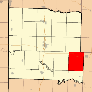
Jackson Township is an inactive township in St. Clair County, Missouri, United States. [1]

A civil township is a widely used unit of local government in the United States that is subordinate to a county. The term town is used in New England, New York, and Wisconsin to refer to the equivalent of the civil township in these states. Specific responsibilities and the degree of autonomy vary based on each state. Civil townships are distinct from survey townships, but in states that have both, the boundaries often coincide and may completely geographically subdivide a county. The U.S. Census Bureau classifies civil townships as minor civil divisions. Currently, there are 20 states with civil townships.

St. Clair County, Missouri U.S. county in Missouri

St. Clair County is a county located in the western portion of the U.S. state of Missouri. As of the 2010 census, the population was 9,805. Its county seat is Osceola. The largest city is Appleton City. The county was organized in 1841 and named after General Arthur St. Clair, Governor of the Northwest Territory. St. Clair was also the 9th president of the United States in Congress Assembled. Under his presidency, the Northwest Ordinance and United States Constitution were passed.

Missouri U.S. state in the United States

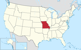
Missouri is a state in the Midwestern United States. With over six million residents, it is the 18th-most populous state of the Union. The largest urban areas are St. Louis, Kansas City, Springfield and Columbia; the capital is Jefferson City. The state is the 21st-most extensive in area. Missouri is bordered by eight states : Iowa to the north, Illinois, Kentucky and Tennessee to the east, Arkansas to the south and Oklahoma, Kansas and Nebraska to the west. In the South are the Ozarks, a forested highland, providing timber, minerals and recreation. The Missouri River, after which the state is named, flows through the center of the state into the Mississippi River, which makes up Missouri's eastern border.

Jackson Township was erected in 1841, taking its name from President Andrew Jackson. [2]

Andrew Jackson 7th president of the United States

Andrew Jackson was an American soldier and statesman who served as the seventh president of the United States from 1829 to 1837. Before being elected to the presidency, Jackson gained fame as a general in the United States Army and served in both houses of Congress. As president, Jackson sought to advance the rights of the "common man" against a "corrupt aristocracy" and to preserve the Union.

Related Research Articles

Hudson Township, Bates County, Missouri Township in Missouri, United States

Hudson Township is one of twenty-four townships in Bates County, Missouri, USA. As of the 2000 census, its population was 229.

Ohio is an unincorporated community in northern St. Clair County, in the U.S. state of Missouri. The community is at the intersection of Missouri routes A and F and south of Cooper Creek. Lowry City is on Missouri Route 13 approximately seven miles to the east and Appleton City is approximately nine miles to the west-northwest on Missouri Route 52.

Jackson Township is a township in Daviess County, in the U.S. state of Missouri.

Chloe is an unincorporated community in St. Clair County, in the U.S. state of Missouri.

Appleton Township is an inactive township in St. Clair County, in the U.S. state of Missouri.

Butler Township is an inactive township in St. Clair County, in the U.S. state of Missouri.

Center Township is an inactive township in St. Clair County, in the U.S. state of Missouri.

Chalk Level is an unincorporated community in St. Clair County, in the U.S. state of Missouri.

Chalk Level Township is an inactive township in St. Clair County, in the U.S. state of Missouri.

Collins Township is an inactive township in St. Clair County, in the U.S. state of Missouri.

Dallas Township is an inactive township in St. Clair County, in the U.S. state of Missouri.

Doyal Township is an inactive township in St. Clair County, in the U.S. state of Missouri.

Monegaw Township is an inactive township in St. Clair County, in the U.S. state of Missouri.

Osage Township is an inactive township in St. Clair County, in the U.S. state of Missouri.

Osceola Township is an inactive township in St. Clair County, in the U.S. state of Missouri.

Polk Township is an inactive township in St. Clair County, in the U.S. state of Missouri.

Roscoe Township is an inactive township in St. Clair County, in the U.S. state of Missouri.

Speedwell Township is an inactive township in St. Clair County, in the U.S. state of Missouri.

Taber Township is an inactive township in St. Clair County, in the U.S. state of Missouri.

Washington Township is an inactive township in St. Clair County, in the U.S. state of Missouri.

References

  1. U.S. Geological Survey Geographic Names Information System: Jackson Township, St. Clair County, Missouri
  2. "St. Clair County Place Names, 1928–1945". The State Historical Society of Missouri. Archived from the original on June 24, 2016. Retrieved November 27, 2016.

Coordinates: 38°08′50″N93°34′10″W / 38.1472°N 93.5694°W / 38.1472; -93.5694

Geographic coordinate system Coordinate system

A geographic coordinate system is a coordinate system that enables every location on Earth to be specified by a set of numbers, letters or symbols. The coordinates are often chosen such that one of the numbers represents a vertical position and two or three of the numbers represent a horizontal position; alternatively, a geographic position may be expressed in a combined three-dimensional Cartesian vector. A common choice of coordinates is latitude, longitude and elevation. To specify a location on a plane requires a map projection.