Related Research Articles

St. Clair County is a county located in the western portion of the U.S. state of Missouri. As of the 2020 census, the population was 9,284. Its county seat is Osceola. The largest city is Appleton City. The county was organized in 1841 and named after General Arthur St. Clair, Governor of the Northwest Territory. St. Clair was also the 9th president of the United States in Congress Assembled. Under his presidency, the Northwest Ordinance and United States Constitution were passed.
Taberville is an unincorporated community in southwestern St. Clair County, Missouri, United States. It is located approximately sixteen miles west of Osceola, situated on the north side of the Osage River. Taberville formerly had a post office, but it has closed and mail is now delivered from nearby Rockville.
Ohio is an unincorporated community in northern St. Clair County, in the U.S. state of Missouri. The community is at the intersection of Missouri routes A and F and south of Cooper Creek. Lowry City is on Missouri Route 13 approximately seven miles to the east and Appleton City is approximately nine miles to the west-northwest on Missouri Route 52.
Cobb is an unincorporated community in St. Clair County, in the U.S. state of Missouri.
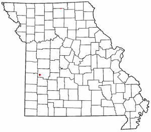
Crooks Springs is an unincorporated community in southern St. Clair County, in the U.S. state of Missouri. The community is on Allen Branch a tributary of the Sac River approximately twelve miles southwest of Osceola.
Harper is an unincorporated community in St. Clair County, in the U.S. state of Missouri.
Johnson City is an unincorporated community in St. Clair County, in the U.S. state of Missouri.
Monegaw Springs is an unincorporated community in St. Clair County, in the U.S. state of Missouri.
Oyer is an unincorporated community in St. Clair County, in the U.S. state of Missouri.
Tiffin is an unincorporated community in southern St. Clair County, in the U.S. state of Missouri.
Butler Township is an inactive township in St. Clair County, in the U.S. state of Missouri.
Center Township is an inactive township in St. Clair County, in the U.S. state of Missouri.
Chalk Level is an unincorporated community in St. Clair County, in the U.S. state of Missouri.
Chalk Level Township is an inactive township in St. Clair County, in the U.S. state of Missouri.
Monegaw Township is an inactive township in St. Clair County, in the U.S. state of Missouri.
Osage Township is an inactive township in St. Clair County, in the U.S. state of Missouri.
Osceola Township is an inactive township in St. Clair County, in the U.S. state of Missouri.
Polk Township is an inactive township in St. Clair County, in the U.S. state of Missouri.
Taber Township is an inactive township in St. Clair County, in the U.S. state of Missouri.
Raney is an unincorporated community in southeastern St. Clair County, in the U.S. state of Missouri. The community is located along Missouri Route V approximately four miles southwest of Vista. It is on a ridge between the Sac River to the west and Coon Creek to the east. Waters of the Truman Reservoir reach into the Sac and Coon Creek to the northwest and northeast of the community.
References
- 1 2 U.S. Geological Survey Geographic Names Information System: Iuka Springs
- ↑ Missouri Atlas & Gazetteer, DeLorme, 1st ed. 1998, p. 43 ISBN 0899332242
- 1 2 "St. Clair County Place Names, 1928–1945". The State Historical Society of Missouri. Archived from the original on June 24, 2016. Retrieved November 27, 2016.
- ↑ "Post Offices". Jim Forte Postal History. Retrieved 27 November 2016.
Municipalities and communities of St. Clair County, Missouri, United States | ||
|---|---|---|
| Cities |  | |
| Villages | ||
| Townships | ||
| Unincorporated communities | ||
| Ghost towns | ||
38°05′51″N93°55′17″W / 38.09750°N 93.92139°W
| | This Saint Clair County, Missouri state location article is a stub. You can help Wikipedia by expanding it. |