Jamestown, Ohio

Last updated

Jamestown, Ohio
Jamestown Opera House from northwest.jpg
OHMap-doton-Jamestown.png
Location of Jamestown, Ohio
Map of Greene County Ohio Highlighting Jamestown Village.png
Location of Jamestown in Greene County
Coordinates: 39°39′22″N83°44′55″W / 39.65611°N 83.74861°W / 39.65611; -83.74861
Country United States
State Ohio
County Greene
Government
  MayorJoshua Bradley [1]
Area
[2]
  Total1.17 sq mi (3.03 km2)
  Land1.17 sq mi (3.02 km2)
  Water0.00 sq mi (0.01 km2)
Elevation
[3]
1,060 ft (320 m)
Population
 (2020)
  Total2,052
  Density1,761.37/sq mi (680.17/km2)
Time zone UTC-5 (Eastern (EST))
  Summer (DST) UTC-4 (EDT)
ZIP code
45335
Area code(s) 937, 326
FIPS code 39-38374 [4]
GNIS feature ID2398290 [3]
Website https://jamestownohio.us/

Jamestown is a village in Greene County, Ohio, United States. The population was 2,052 at the 2020 census.

Contents

Jamestown is part of the Dayton Metropolitan Statistical Area.

History

Jamestown was platted in 1816, and named after Jamestown, Virginia, the native home of a first settler. [5]

Geography

Parts of Jamestown are located in Silvercreek, Ross, and New Jasper Townships.

According to the United States Census Bureau, the village has a total area of 1.21 square miles (3.13 km2), all of it land. [6]

Jamestown is located south of U.S. Route 35 on State Route 72. It is east of Lake Shawnee.

Demographics

Historical population
CensusPop.Note
1850 337
1860 55965.9%
1870 532−4.8%
1880 87764.8%
1890 1,10425.9%
1900 1,2059.1%
1910 1,133−6.0%
1920 1,039−8.3%
1930 944−9.1%
1940 1,07914.3%
1950 1,34524.7%
1960 1,73028.6%
1970 1,7903.5%
1980 1,702−4.9%
1990 1,7945.4%
2000 1,9176.9%
2010 1,9934.0%
2020 2,0523.0%
U.S. Decennial Census [7]

2010 census

As of the census [8] of 2010, there were 1,993 people, 758 households, and 524 families living in the village. The population density was 1,647.1 inhabitants per square mile (635.9/km2). There were 836 housing units at an average density of 690.9 per square mile (266.8/km2). The racial makeup of the village was 95.1% White, 2.4% African American, 0.1% Native American, 0.2% Asian, 0.6% from other races, and 1.7% from two or more races. Hispanic or Latino of any race were 0.7% of the population.

There were 758 households, of which 36.5% had children under the age of 18 living with them, 46.8% were married couples living together, 16.8% had a female householder with no husband present, 5.5% had a male householder with no wife present, and 30.9% were non-families. 25.3% of all households were made up of individuals, and 12.3% had someone living alone who was 65 years of age or older. The average household size was 2.56 and the average family size was 3.04.

The median age in the village was 36.7 years. 25.7% of residents were under the age of 18; 9.5% were between the ages of 18 and 24; 25.2% were from 25 to 44; 23.6% were from 45 to 64; and 16% were 65 years of age or older. The gender makeup of the village was 45.3% male and 54.7% female.

2000 census

As of the census [4] of 2000, there were 1,917 people, 743 households, and 529 families living in the village. The population density was 1,579.3 inhabitants per square mile (609.8/km2). There were 791 housing units at an average density of 651.7 per square mile (251.6/km2). The racial makeup of the village was 94.47% White, 4.07% African American, 0.42% Native American, 0.47% Asian, 0.16% from other races, and 0.42% from two or more races. Hispanic or Latino of any race were 0.47% of the population.

There were 743 households, out of which 38.0% had children under the age of 18 living with them, 50.3% were married couples living together, 15.3% had a female householder with no husband present, and 28.8% were non-families. 25.0% of all households were made up of individuals, and 12.2% had someone living alone who was 65 years of age or older. The average household size was 2.58 and the average family size was 3.08.

In the village, the population was spread out, with 29.2% under the age of 18, 8.5% from 18 to 24, 30.3% from 25 to 44, 19.5% from 45 to 64, and 12.5% who were 65 years of age or older. The median age was 34 years. For every 100 females there were 92.1 males. For every 100 females age 18 and over, there were 86.9 males.

The median income for a household in the village was $40,599, and the median income for a family was $43,705. Males had a median income of $32,679 versus $21,080 for females. The per capita income for the village was $17,117. About 9.4% of families and 11.2% of the population were below the poverty line, including 13.4% of those under age 18 and 20.1% of those age 65 or over.

Education

The Greeneview Local School District operates three schools in the village: Greeneview Elementary School, Greeneview Middle School, and Greeneview High School. [9] Jamestown has a public library, a branch of the Greene County Public Library. [10]

Notable natives

Related Research Articles

<span class="mw-page-title-main">Greene County, Ohio</span> County in Ohio, United States

Greene County is located in the southwestern portion of Ohio. As of the 2020 census, the population was 167,966. Its county seat is Xenia and its largest city is Beavercreek. The county was established on March 24, 1803 and named for General Nathanael Greene, an officer in the Revolutionary War. Greene County is part of the Dayton, OH Metropolitan Statistical Area.

<span class="mw-page-title-main">Rockbridge, Illinois</span> Village in Illinois, United States

Rockbridge is a village in Greene County, Illinois, United States. The population was 175 at the 2020 census.

<span class="mw-page-title-main">Wilmington, Greene County, Illinois</span> Village in Illinois, United States

Wilmington (Patterson) is a village in Greene County, Illinois, United States. The population was 91 at the 2020 census.

<span class="mw-page-title-main">Greene, Maine</span> Town in the state of Maine, United States

Greene is a town in Androscoggin County, Maine, United States. The population was 4,376 at the 2020 census. It is included in both the Lewiston-Auburn, Maine metropolitan statistical area and the Lewiston-Auburn, Maine Metropolitan New England city and town area. The central village in the town comprises the Greene census-designated place.

<span class="mw-page-title-main">Merrill, Michigan</span> Village in Michigan, United States

Merrill is a village in Saginaw County in the U.S. state of Michigan. The population was 663 at the 2020 census. The village is located within Jonesfield Township.

<span class="mw-page-title-main">Battlefield, Missouri</span> City in Missouri, United States

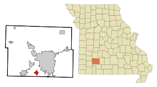
Battlefield is a city in Greene County, Missouri, United States. As of the 2020 census, the city's population was 5,990. It is part of the Springfield, Missouri Metropolitan Statistical Area. The town has no post office and shares the ZIP code (65619) with Brookline.

<span class="mw-page-title-main">Jamestown, Missouri</span> Town in Missouri, United States

Jamestown is a village in northeastern Moniteau County, Missouri, United States. The population was 330 at the 2020 census, down from 386 in 2010. It is part of the Jefferson City metropolitan area.

Jamestown West is a census-designated place (CDP) located near Jamestown in Chautauqua County, New York, United States. Also known as West Ellicott because of its location in the Town of Ellicott, the area population was 2,408 as of the 2010 census.

<span class="mw-page-title-main">Sabina, Ohio</span> Village in Ohio, United States

Sabina is a village in Clinton County, Ohio, United States. As of the 2020 census, the village had a total population of 2,499.

<span class="mw-page-title-main">Walton Hills, Ohio</span> Village in Ohio, United States

Walton Hills is a village in Cuyahoga County, Ohio, United States. The population was 2,033 at the 2020 census. A suburb of Cleveland, it is a part of the Cleveland metropolitan area.

<span class="mw-page-title-main">Valleyview, Ohio</span> Village in Ohio, United States

Valleyview is a village in Franklin County, Ohio, United States. The population was 669 at the 2020 census.

<span class="mw-page-title-main">Bowersville, Ohio</span> Village in Ohio, United States

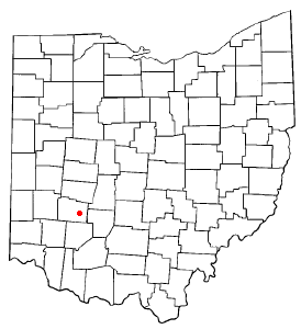
Bowersville is a village in Greene County, Ohio, United States. The population was 261 at the 2020 census. It is part of the Dayton Metropolitan Statistical Area.

<span class="mw-page-title-main">Shawnee Hills, Greene County, Ohio</span> Census-designated place in Ohio, United States

Shawnee Hills is a census-designated place (CDP) in Greene County, Ohio, United States. Shawnee Hills consists of a planned community centered on the 250-acre (1.0 km2) Shawnee Lake. The population was 2,230 at the 2020 census. It is part of the Dayton Metropolitan Statistical Area, and should not be confused with the incorporated village of Shawnee Hills in Delaware County.

<span class="mw-page-title-main">Riverside, Ohio</span> City in Ohio, United States

Riverside is a city in Montgomery County, Ohio, United States. The population was 24,474 at the 2020 census. A suburb of Dayton, it is part of the Dayton metropolitan area.

<span class="mw-page-title-main">Hartville, Ohio</span> Village in Ohio, United States

Hartville is a village in northern Stark County, Ohio, United States. The population was 3,329 at the 2020 census. It is part of the Canton–Massillon metropolitan area. Hartville lies halfway between Akron and Canton at the intersection of State Routes 43 and 619.

<span class="mw-page-title-main">Jamestown, Oklahoma</span> Unincorporated community in Oklahoma, United States

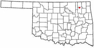
Jamestown is an unincorporated community in Rogers County, Oklahoma, United States. The population was 10 at the 2000 census, at which time it was a town; the community disincorporated in 1998, but the change was not reported to the Census Bureau until 2006.

<span class="mw-page-title-main">Bellevue, Wisconsin</span> Village in Wisconsin, United States

Bellevue is a village in Brown County, Wisconsin. It was a town until incorporating as a village on February 14, 2003. The population was 15,935 at the time of the 2020 census. Bellevue is part of the Green Bay metropolitan area. Bellevue sits around 4.34 miles (6.99 km) east from central Green Bay.

<span class="mw-page-title-main">Avoca, Wisconsin</span> Village in Wisconsin, United States

Avoca is a village in Iowa County, Wisconsin, United States. The population was 637 at the 2010 census. It is part of the Madison Metropolitan Statistical Area. It is named after Avoca in Ireland.

<span class="mw-page-title-main">Clifton, Ohio</span> Village in Ohio, United States

Clifton is a village in Clark and Greene counties in the U.S. state of Ohio and is home to the Clifton Mill, one of the largest water-powered grist mills still in existence. The population was 131 at the 2020 census.

<span class="mw-page-title-main">Greene (village), New York</span> Village in New York, United States

Greene is a village in Chenango County, New York, United States. The population was 1,580 at the 2010 census. The village is named after General Nathanael Greene. It is within the town of Greene and is northeast of Binghamton.

References

  1. "Village of Jamestown Ohio - Government Page". www.jamestownohio.us. Retrieved June 7, 2020.
  2. "ArcGIS REST Services Directory". United States Census Bureau. Retrieved September 20, 2022.
  3. 1 2 U.S. Geological Survey Geographic Names Information System: Jamestown, Ohio
  4. 1 2 "U.S. Census website". United States Census Bureau . Retrieved January 31, 2008.
  5. Broadstone, Michael A. (1918). History of Greene County, Ohio: Its People, Industries and Institutions, Volume 1. B.F. Bowen. p. 388.
  6. "US Gazetteer files 2010". United States Census Bureau. Archived from the original on July 2, 2012. Retrieved January 6, 2013.
  7. "Census of Population and Housing". Census.gov. Retrieved June 4, 2015.
  8. "U.S. Census website". United States Census Bureau . Retrieved January 6, 2013.
  9. "Our schools". Greeneview Local School District. Retrieved February 25, 2018.
  10. "Locations". Greene County Public Library. Retrieved February 25, 2018.