This article is about modern city of Korla, sometimes known as Kroran. For the ancient state also known as Krorän, see Loulan Kingdom. For the organist, see Korla Pandit.
Korla has existed since at least the Han dynasty. Korla is known for its production of fragrant pears and is a production center for the Tarim oil fields.
History
Han Dynasty
Korla was known as Yuli (尉犁) (reconstructed pronunciation of first character:*i̯wəd)[12] during the Han Dynasty. Yuli is said in the Hanshu or 'History of the Former Han' (covering the period 125 BCE to 23 CE),to have had 1,200 households,9,600 individuals and 2,000 people able to bear arms. It also mentions that it adjoined Shanshan and Qiemo (Charchan) to the south.[13]
In 61 CE,the Xiongnu led some 30,000 troops from 15 kingdoms including Korla,Karashahr,and Kucha in a successful attack on Khotan.
In 94 CE,the Chinese general Ban Chao sent soldiers to punish the kingdoms of Yanqi (Karashahr),Weixu (Hoxud),Yuli (Korla),and Shanguo (in the western Kuruk mountains).
"He then sent the heads of the two kings of Yanqi (Karashahr) and Yuli (Korla) to the capital where they were hung in front of the residences of the Man and Yi princes in the capital (Luoyang). (Ban) Chao then appointed Yuan Meng,who was the Yanqi (Karashahr) Marquis of the Left,king (of Kashgar). The kings of Yuli (Korla),Weixu (Hoxud),and Shanguo (in the western Kuruk mountains) were all replaced."[14]
After the rebellion of the "Western Regions" (106−125 CE),only the kings of Korla and Hoxud refused to submit to the Chinese. Ban Yong,the son of Ban Chao,along with the Governor of Dunhuang,attacked and defeated them.[15]
Tarim Basin in the 3rd century
Three Kingdoms era
The 3rd century Weilüe records that Korla,Hoxud and Shanwang (Shanguo) were all dependencies of Karashahr.[16]
Yettishar
The contemporaneous historian Musa Sayrami (1836–1917) stated that ruler Yaqub Beg of Yettishar was poisoned on May 30,1877,in Korla by the former hakim (local city ruler) Niyaz Hakim Beg of Yarkand,[17] although Niyaz Hakim Beg and other sources stated that his death was by suicide or in battle against the Qing dynasty.[17][18]
Qing dynasty
Francis Younghusband,passed through "Korlia" in 1887 on his overland journey from Beijing to India. He described it as being prosperous and the country round about well-cultivated,with more land under cultivation than any other town he had passed. Maize seemed to be the major crop but rice was also grown. There was a small Chinese town,about 400 yards (370m) square with mud walls about 35 feet (11m) high and with a ditch. There were round bastions at the angles,but none at the gateway. A mile (1.6km) south was the Turk town,but its walls were in ruins. It had one main street about 700 yards (640m) long. "The shops are somewhat better than at Karashar,but not so good as at Turfan."[19]
People's Republic of China
Korla was incorporated as a city on September 30,1979.[20]
On January 8,1965,more than 170 Chinese Communist cadres were immolated by Mongols during an anti-Communist riot at a state farm in Korla (Kurla).[10]
In September 2019,drone video appeared which ASPI (a defense industries funded Australian think tank)[21][22] alleged as showing the mass transfer of hundreds of ethnic minority prisoners,which drew the comment "deeply disturbing" from Australian Foreign Minister Marise Payne in describing the video.[23]
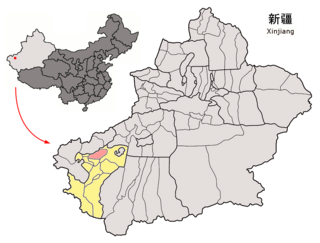
Geography
Korla is approximately 200 kilometres (120mi) southwest from Ürümqi,although,due to the intervening Tian Shan,the road distance is considerably greater.
The Iron Gate Pass (Tiemen Pass) leading to Karasahr is about 7 kilometres (4.3mi) north of the city and,as it was easily defended,playing an important part in protecting the ancient Silk Roads from raiding nomads from the north.
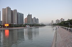
The Kaidu River,also known as the Konqi River or Kongque River,flows through the center of Korla,a unique feature amongst cities in Xinjiang. While the literal meaning of the Chinese name "Kongque River" is "Peacock River",the name originates from a semantically distorted transliteration of the Uyghur name "Konqi Darya" which means "Tanner's River".[24]
Climate
Korla has a cold desert climate (Köppen climate classificationBWk) with extreme seasonal variation in temperature. The monthly 24-hour average temperature ranges from −6.6°C (20.1°F) in January to 26.8°C (80.2°F),and the annual mean is 12.0°C (53.6°F),which is still warmer than most locales at the same latitude further east in the country. Precipitation totals only 59.2 millimetres (2.33in) annually,and mostly falls in summer,as compared to an annual evaporation rate of about 2,800mm (110in);there are about 3,000 hours of bright sunshine annually. The frost-free period averages 210 days. The period between April and October closely resembles subtropical climates,but the continental nature is facilitated by the rapid drop of temperatures going into winter.
Climate data for Korla,elevation 900m (3,000ft),(1991–2020 normals,extremes 1971–2010)
In the 2010 Chinese Census,the city had a total population of 549,324 people,a significant increase from the 381,943 recorded in the 2000 Census.[29] The city is home to 23 ethnic groups.[20]
The city had 430,000 inhabitants in 2007,increasing with 20,000 people every year,majority of whom were Han Chinese,with a large minority of Uyghurs (about 100,000) and smaller numbers of Mongols and Huis.[citation needed]
The proportion of nationalities in Korla City,2018
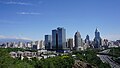
Korla has long been the biggest centre in the region after Karashahr/Yanqi itself,having abundant water and extensive farmlands,as well as controlling the main routes to the south and west of Karashahr/Yanqi.[citation needed] Due to the discovery of oil in the Taklamakan Desert,Korla is now both more populous and developed than Karashar/Yanqi.[citation needed]PetroChina's Tarim oil fields operations are headquartered in Korla.[20][31]
The city reported a fiscal revenue of 4.572 billion Yuan in 2019.[20] In the same year,the city's GDP grew 5.6%,fixed asset investment grew 10%,the public budget grew 5%,retail sales grew 8%,and the city's CPI grew 2.3%.[20]
Korla is known for its production of fragrant pears (库尔勒香梨).[32]
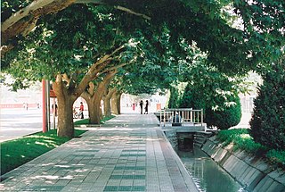
The city's main attractions include the Iron Gate Pass,Lotus Pond (莲花池),Sun Island (太阳岛),Princess Peak (公主峰),Yuzigan Old City (玉子干旧城),Tuowuqi Ancient City (托务其古城),Airlike Ancient City (爱力克古城),Ku'erchu Mound (库尔楚土墩),Jiamai Mosque (加麦清真寺),and Yeyungou Ruins (野云沟遗址).[32]
1 2 Mihray Abdilim, Joshua Lipes (21 September 2020). "Missing Uyghur Confirmed Dead by UN Working Group on Disappearances". Radio Free Asia. Translated by Elise Anderson. Retrieved 23 September 2020. Most recently, Hapiz had been conducting business between Kashgar and Korla (Kuerle)—a county-level city in Bayin'gholin Mongol (Bayinguoleng Menggu) Autonomous Prefecture and the XUAR's second-largest city—several prefectures away.
↑ "EXCAVATIONS iv. In Chinese Turkestan". Encyclopædia Iranica. Retrieved 24 September 2020. Large-scale works were undertaken at the site of Šikšin, half-way between the towns of Qara Šahr and Kurla, which occupies a plateau of about 15 hectares.
↑ Hulsewé, A. F. P. and Loewe, M. A. N. 1979. China in Central Asia: The Early Stage 125 BC – AD 23: an annotated translation of chapters 61 and 96 of the History of the Former Han Dynasty, p. 177. E. J. Brill, Leiden.
↑ Hill, John E. 2004. The Peoples of the West from the Weilüe (魏略by Yu Huan魚豢: A Third Century Chinese Account Composed between 239 and 265 CE. Draft annotated English translation.
↑ Younghusband, Francis E. (1896). The Heart of a Continent, p. 148. John Murray, London. Facsimile reprint: (2005) Elbiron Classics. ISBN1-4212-6551-6 (pbk); ISBN1-4212-6550-8 (hardcover).
1 2 3 4 5 库尔勒概览[Korla Overview] (in Chinese). Korla People's Government. 2020-06-10. Archived from the original on 2020-07-16. Retrieved 2020-07-16.
↑ Nara Shiruku Rōdo-haku Kinen Kokusai Kōryū Zaidan, Shiruku Rōdo-gaku Kenkyū Sentā: Opening up the Silk Road: the Han and the Eurasian world, Nara International Foundation Commemorating the Silk Road Exposition, 2007
↑ 库尔勒 - 气象数据 -中国天气网 (in Chinese). Weather China. Retrieved 29 November 2022.
↑ 2019年统计用区划代码. stats.gov.cn (in Chinese). 2019. Archived from the original on 2020-07-16. Retrieved 2020-07-16.
↑ 库尔勒市历史沿革. xzqh.org (in Chinese). 2015-01-30. Archived from the original on 2020-07-16. Retrieved 2020-07-16.
↑ 3-7 各地、州、市、县(市)分民族人口数[3-7 Population by Nationality by Prefecture, State, City and County (City)]. tjj.xinjiang.gov.cn (in Chinese). Statistical Bureau of Xinjiang Uyghur Autonomous Region. 2020-06-10. Archived from the original on 2020-11-01. Retrieved 2021-06-11.
↑ 公司简介[Company Profile]. China National Petroleum Corporation (in Chinese). Archived from the original on 2019-07-23. Retrieved 2020-07-16.
1 2 3 库尔勒市概况地图. xzqh.org (in Chinese). 2015-01-30. Archived from the original on 2020-07-16. Retrieved 2020-07-16.
Sources
Hill, John E. (2009). Through the Jade Gate to Rome: A Study of the Silk Routes during the Later Han Dynasty, 1st to 2nd Centuries CE. BookSurge, Charleston, South Carolina. ISBN978-1-4392-2134-1.
Mallory, J. P. and Mair, Victor H. 2000. The Tarim Mummies: Ancient China and the Mystery of the Earliest Peoples from the West. Thames & Hudson, London.
Stein, Aurel M. 1921. Serindia: Detailed report of explorations in Central Asia and westernmost China, 5 vols. London & Oxford. Clarendon Press. Reprint: Delhi. Motilal Banarsidass. 1980.
Stein Aurel M. 1928. Innermost Asia: Detailed report of explorations in Central Asia, Kan-su and Eastern Iran, 5 vols. Clarendon Press. Reprint: New Delhi. Cosmo Publications. 1981.
von Le Coq, Albert. 1928. Buried Treasures of Turkestan. Reprint with Introduction by Peter Hopkirk, Oxford University Press. 1985.
Tashkurgan Tajik Autonomous County is an autonomous county of Kashgar Prefecture, in western Xinjiang, China. The county seat is Tashkurgan. The county is the only Tajik (Pamiri) autonomous county in China.
Bayingolin Mongol Autonomous Prefecture is an autonomous prefecture in the southeastern Xinjiang, China. It borders Gansu to the east, Qinghai to the southeast and the Tibet Autonomous Region to the south. It is the largest prefecture-level division nationally, with an area of 471,480 km2 (182,040 sq mi), which is even larger than its neighboring province of Gansu. The prefectural capital is Korla. Despite being designated an autonomous area for Mongols in China, only about four percent of Bayingolin's population is Mongol.
Jeminay County or Jimunai County, is a county situated in the north of the Xinjiang Uyghur Autonomous Region and is under the administration of the Altay Prefecture.
Emin County, the official romanized name, also transliterated from Mongolian as Dörbiljin County, is a county situated in the north of the Xinjiang Uyghur Autonomous Region and is under the administration of the Tacheng Prefecture, bordering Kazakhstan's districts of Tarbagatay and Zaysan. It has an area of 9,092 km2 (3,510 sq mi) with a population of 200,000. The Postcode is 834600.
Kuqa is a county-level city in Aksu Prefecture, Xinjiang Uyghur Autonomous Region, China. It was once the homeland of the ancient Buddhist Kingdom of Kucha.
Xayar County, also Shayar County or, from Mandarin Chinese, Shaya, is a county in the Xinjiang Uyghur Autonomous Region and is under the administration of the Aqsu Prefecture. It contains an area of 31,868 km2 (12,304 sq mi). According to the 2004 census it has a population of 210,000.
Onsu County and from Mandarin Chinese Wensu County, is a county in the Xinjiang Uyghur Autonomous Region and is under the administration of the Aksu Prefecture, bordering Kyrgyzstan's Issyk-Kul Region to the northwest. It contains an area of 14,309 km2 (5,525 sq mi).
Poskam County, also Zepu County is a county in Kashgar Prefecture, Xinjiang Uyghur Autonomous Region, China. The county is located on the southern bank of the Yarkand River, also known as the Zarafshān River (泽勒普善河). Poskam County is bordered to the north and west across the Yarkand River by Yarkant County (Shache) and to the south and east by Kargilik County (Yecheng).
Payzawat County, also via SASM/GNC romanization as Payziwat County, and via Mandarin Chinese as Jiashi County is a county in Kashgar Prefecture, Xinjiang Uyghur Autonomous Region, China, on the western rim of the Taklamakan Desert. To the east, the county borders Maralbexi County, to the south Yopurga County.
Kargilik County, also known as Yecheng County, is a county in southwest of the Xinjiang Uyghur Autonomous Region and is under the administration of the Kashgar Prefecture. It contains an area of 28,600 km2. To the north, the county borders Makit County. To the east, the county borders Guma County (Pishan) in Hotan Prefecture. To the west, the county borders Yarkant County, Poskam County and Taxkorgan Tajik Autonomous County. In the south, the county has a border of more than 80 km (50 mi) with Pakistan and India administered areas of Kashmir.
Makit County is a county in Kashgar Prefecture, Xinjiang Uyghur Autonomous Region, China. It contains an area of 10,927 km2 (4,219 sq mi). The Yarkand River passes through the county. The county is bordered to the north by Maralbexi County, to the east by Guma County (Pishan) in Hotan Prefecture, to the west by Yarkant County, and to the south by Kargilik County.
Akto County is a county in Kizilsu Kyrgyz Autonomous Prefecture, Xinjiang Uygur Autonomous Region, China. The county borders Tajikistan and Kyrgyzstan and has two towns, 11 townships, four state-owned farms and a plant nursery under its jurisdiction with the county seat being Akto Town. The county contains an area of 24,555 km2 (9,481 sq mi) and has a population of 221,526 as of 2015, of 231,756 as of 2017.
Hejing County is located in the central-southern part of the Tian Shan mountains of Xinjiang, in the north-west of Bayingolin Mongol Autonomous Prefecture. The northernmost county-level division of Bayingolin, it borders Ürümqi City to the north, from which it is 190 km (120 mi) as the crow flies, and Korla City to the south, which is 80 km (50 mi) away. It borders 15 cities and counties and is the most bordered county in the world.
Yuli County as the official Romanized name, also transliterated from Mongolian as Lopnur County, is a county in the Xinjiang Uyghur Autonomous Region and is under the administration of the Bayin'gholin Mongol Autonomous Prefecture. It contains an area of 59,399 km2 (22,934 sq mi). According to the 2002 census, it has a population of 100,000.
Hoxud County is a county in the Xinjiang Uyghur Autonomous Region and is under the administration of the Bayin'gholin Mongol Autonomous Prefecture. It contains an area of 12,753 km2 (4,924 sq mi). According to the 2002 census, it has a population of 60,000.
Ruoqiang County as the official romanized name, also transliterated from Uyghur as Qakilik County, is a county in the Xinjiang Uyghur Autonomous Region, China under the administration of the Bayingolin Mongol Autonomous Prefecture. It covers an area of 198,318 square kilometres (76,571 sq mi), making it the largest county-level division in the country.
Yanqi Hui Autonomous County is an autonomous county in the Xinjiang Uyghur Autonomous Region and is under the administration of the Bayin'gholin Mongol Autonomous Prefecture. It has an area of 2,429 km2 (938 sq mi). According to the 2002 census, it has a population of 120,000. The Shikshin Buddhist Temple Ruins are located in Yanqi County, about 25–30 km (16–19 mi) southwest of the town of Yanqi.
Yutian County, also transliterated from Uyghur as Keriya County, is a county in Hotan Prefecture, Xinjiang Uyghur Autonomous Region, China. It is based at the Keriya Town, and is separate from Hotan County, which is another county in the same prefecture. The Yutian County has an area of 39,023 km2 (15,067 sq mi). According to the 2002 census, it has a population of 220,000. The county is bounded on the north by Aksu Prefecture, on the east by Minfeng/Niya County, on the west by Qira County and on the south by the Rutog and Gertse counties of the Tibet Autonomous Region.
Toksun County is a county in Turpan, Xinjiang Uyghur Autonomous Region, China.
Turtay Farm is a local state-owned farm of Akto County in Xinjiang Uygur Autonomous Region, China. The farm is located in the northeast of Akto County and 8 kilometers away northeast of Akto Town. It covers an area of 43 square kilometers with 1,238 households and a population of 4,768. The farm is divided into 8 production teams and quartered in Turtay Village of Jamaterek Township.
This page is based on this Wikipedia article Text is available under the CC BY-SA 4.0 license; additional terms may apply. Images, videos and audio are available under their respective licenses.