Kuala Langat District

Last updated
Kuala Langat District
Daerah Kuala Langat
Other transcription(s)
   Jawi كوالا لاڠت
   Chinese 瓜拉冷岳县
   Tamil கோலா லங்காட்
The Seal of Kuala Langat Municipal Council.png
Daerah Kuala Langat Highlighted in the State of Selangor, Malaysia.svg
Location of Kuala Langat District in Selangor
Kuala Langat District
Malaysia location map with districts.svg
Red pog.svg
Kuala Langat District
Location of Kuala Langat District in Malaysia
Coordinates: 2°50′N101°30′E / 2.833°N 101.500°E / 2.833; 101.500
Country Flag of Malaysia.svg  Malaysia
State Flag of Selangor.svg  Selangor
Seat Teluk Datok
Largest town Banting
Local area government(s) Kuala Langat Municipal Council
Government
  District officerRosli Othman [1]
   Sultan's RepresentativeMohamed Al Haj Harun [2]
Area
[3]
  Total858 km2 (331 sq mi)
Population
 (2020) [4]
  Total307,787
  Density360/km2 (930/sq mi)
Time zone UTC+8 (MST)
  Summer (DST) UTC+8 (Not observed)
Postcode
425xx-428xx, 471xx
Calling code +6-03-31, +6-03-51, +6-03-5614, +6-03-80
Vehicle registration plates B
Kuala Langat District and Land Office Kuala Langat District and Land Office.jpg
Kuala Langat District and Land Office

The Kuala Langat District is a district of Selangor, Malaysia. It is situated in the southwestern part of Selangor. It covers an area of 858 square kilometres, and had a population of 307,787 at the 2020 Census (exclude foreign). [4] It is bordered by the districts of Klang and Petaling to the north and Sepang to the east. The Strait of Malacca forms its western border.

Contents

Among the major towns in Kuala Langat are Banting, Jugra, Teluk Datok, Morib and an island Carey Island.

Administrative divisions

Map of Kuala Langat District, Selangor.svg

Kuala Langat District is divided into 7 mukims, which are: [5]

Demographics

Historical population
YearPop.±%
1991 130,090    
2000 192,176+47.7%
2010 220,214+14.6%
2020 307,787+39.8%
Source: [6]

Land use

Kuala Langat is predominantly an agricultural district, with the main crop being oil-palm. In addition, Kuala Langat has several forest reserves, including the Kuala Langat North Forest Reserve and the Kuala Langat South Forest Reserve, both of which are important for the conservation of flora and fauna. [7]

Tourist attractions

Kuala Langat is famous for its agricultural produce, industries that recycle scrap metal, home stay programmes for tourists and for its National Space Centre in Kanchong Darat. Local farmers transform scrap metal from cars, electronics and other household appliances into large 12 meter transformers. [8]

Infrastructure

Putrajaya and the Kuala Lumpur International Airport (KLIA), linked by new highways, have become the catalyst for Kuala Langat’s development. Road networks and infrastructure in the district are good, making it viable for manufacturers to transport their finished goods on freight trucks to Kuala Lumpur, KLIA and Port Klang.[ citation needed ]

Bandar Saujana Putra, located in the far-north of the district, was established in 2003 by LBS Bina Berhad and is located near Putra Heights, UEP Subang Jaya (USJ) and Puchong, as well as Cyberjaya, Putrajaya, and Teluk Panglima Garang. [9]

The Teluk Panglima Garang Free Trade Zone, industries manufacturing electronic components and car parts have created many job opportunities for locals.[ citation needed ]

Morib is being moulded into an education hub and that plans were afoot to set up a few educational institutions in Jugra. Currently, there is the Kuala Langat Community College and Industrial Training Institute. Other institutions being built are a matriculation college, a polytechnic and a MARA skills training institute.[ citation needed ]

Kota Kemuning is a township located in the constituency of Kota Raja developed by Hicom-Gamuda Development Sdn Bhd in 1994 and is renowned as one of the Klang Valley’s finest residences with its healthy and harmonious living environment.

Bandar Rimbayu dubbed as "The Township Nature Perfected" is a 1,879-acre premier township situated adjacent to Kota Kemuning is a development that consists of a mixed development of residential, commercial, recreational and parkland components. The township is spread over 4 precincts: Flora, Fauna, Bayu and Commercial Hub. Surrounded by 4 major highways to Kuala Lumpur City Centre, Subang, Petaling Jaya, Damansara, Puchong, Shah Alam and Klang Valley gives the township excellent connectivity.

Federal Parliament and State Assembly Seats

Kuala Langat, Selangor Parliament and State Assembly Electoral Districts Kuala Langat, Federal Parliament and State Assembly Seats.svg
Kuala Langat, Selangor Parliament and State Assembly Electoral Districts


List of Kuala Langat district representatives in the Federal Parliament (Dewan Rakyat)

ParliamentSeat NameMember of ParliamentParty
P112 Kuala Langat Ahmad Yunus Hairi Perikatan Nasional (PAS)
P113 Sepang Aiman Athirah Sabu Pakatan Harapan (AMANAH)


List of Kuala Langat district representatives in the State Legislative Assembly (Dewan Undangan Negeri)

ParliamentStateSeat NameState AssemblymanParty
P112N51 Sijangkang Ahmad Yunus HairiPerikatan Nasional (PAS)
P112N52 Banting Papparaidu VeramanPakatan Harapan (DAP)
P112N53 Morib Roznizan AhmadPerikatan Nasional (BERSATU)
P113N54 Tanjong Sepat Borhan bin Ahmad ShahPakatan Harapan (PKR)
P113N55 Dengkil Jamil SallehPerikatan Nasional (BERSATU)

See also

Related Research Articles

<span class="mw-page-title-main">Selangor</span> State of Malaysia

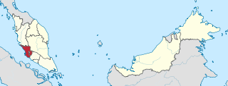
Selangor, also known by its Arabic honorific Darul Ehsan, or "Abode of Sincerity", is one of the 13 Malaysian states. It is on the west coast of Peninsular Malaysia and is bordered by Perak to the north, Pahang to the east, Negeri Sembilan to the south, and the Strait of Malacca to the west. Selangor surrounds the federal territories of Kuala Lumpur and Putrajaya, both of which were previously part of it. Selangor has diverse tropical rainforests and an equatorial climate. The state's mountain ranges belong to the Titiwangsa Mountains, which is part of the Tenasserim Hills that covers southern Myanmar, southern Thailand and Peninsular Malaysia, with Mount Semangkok as the highest point in the state.

<span class="mw-page-title-main">Sepang District</span> District of Malaysia in Selangor

The Sepang District is a district located in the southern part of the state of Selangor in Malaysia. Sepang District covers an area of around 600 square kilometres, and had a population of 190,889 in the 2010 Census.

<span class="mw-page-title-main">Petaling District</span> District of Malaysia in Selangor

The Petaling District is a district located in the heart of Selangor in Malaysia. Petaling is not to be confused with the city of Petaling Jaya located in it, nor the mukim of Petaling under Petaling Jaya City. The district office is located in Subang.

<span class="mw-page-title-main">Jugra</span> Town in Selangor, Malaysia

Jugra is a mukim, historical town and former royal town in Kuala Langat District, Selangor, Malaysia. It is separated from Pulau Carey by the Langat River. The town is administered by the Zone 16 of the Kuala Langat Municipal Council.

<span class="mw-page-title-main">Subang Jaya</span> City in Selangor, Malaysia

Subang Jaya is a city in Petaling District, Selangor, Malaysia. It comprises the southern third district of Petaling. It consists of the neighbourhoods from SS12 to SS19, UEP Subang Jaya (USJ), Putra Heights, Batu Tiga as well as PJS7, PJS9 and PJS11 of Bandar Sunway, the latter of which are partially jurisdictional within Petaling Jaya under the MBPJ. The city is governed by Subang Jaya City Council (MBSJ), which also governs other areas of the Petaling district, such as Puchong and Seri Kembangan. According to Subang Jaya City Council, Subang Jaya has a population of 968,930 in 2020, which makes it the sixth largest city in Malaysia by population.

<span class="mw-page-title-main">Gombak District</span> District of Malaysia in Selangor

The Gombak District is an administrative district located in the state of Selangor, Malaysia. The district was created on February 1, 1974, the same day when Kuala Lumpur was declared a Federal Territory. Until 1997, Rawang was the district capital; the capital has been moved to Bandar Baru Selayang. Gombak borders Kuala Lumpur to the southeast and the Genting Highlands to the east. Both Gombak and Kuala Lumpur, along with some other districts in Selangor, are situated within the Klang Valley. Other localities that are situated in Gombak district include Batu Arang, Kuang, Rawang, Kundang, Gombak Town, Selayang, Batu Caves and Hulu Kelang.

The South Klang Valley Expressway, or SKVE South Klang Valley Expressway, is an expressway in the southern part of Klang Valley, Malaysia's most densely populated region. This 51.7 km (32.1 mi) dual-carriageway provides links to the booming towns in southern Klang Valley, including the country's administrative capital, Putrajaya. South Klang Valley Expressway is the fifth east–west-oriented expressway in the Klang Valley after the Federal Highway, the New Klang Valley Expressway (NKVE), the Kuala Lumpur–Kuala Selangor Expressway (LATAR) and the Shah Alam Expressway (KESAS).

<span class="mw-page-title-main">Puchong</span> Town in Selangor, Malaysia

Puchong is a major town and a parliamentary constituency in Petaling District, Selangor, Malaysia.

<span class="mw-page-title-main">Sunway City</span> Township in Subang Jaya, Selangor, Malaysia

Sunway City is an 800-acre integrated township in Subang Jaya, Selangor, Malaysia. This township is named after its developer, Sunway Group, which had also got its name from Sungai Way, a suburb in Selangor.

Transport in Greater Kuala Lumpur includes a road network, a railway network, airports, and other modes of public transport. The Klang Valley is an urban conglomeration consisting of the city of Kuala Lumpur, as well as surrounding towns and cities in the state of Selangor. The Klang Valley has the country's largest airport, the Kuala Lumpur International Airport (KLIA), as well as the country's largest intermodal transport hub and railway station, Kuala Lumpur Sentral.

<span class="mw-page-title-main">Bandar Saujana Putra</span> Place in Selangor, Malaysia

Bandar Saujana Putra is a township in Kuala Langat District, Selangor, Malaysia.

<span class="mw-page-title-main">Greater Kuala Lumpur</span> Metropolitan area in Malaysia

Greater Kuala Lumpur is the geographical term that determines the boundaries of metropolitan Kuala Lumpur in Malaysia. Though similar to the term "Klang Valley", there remains a variation between the two. It is similar to Greater London and Greater Toronto. The metropolitan area covers 5,194.72 square km of land.

<span class="mw-page-title-main">Klang District</span> District of Malaysia in Selangor

The Klang District is a district in Selangor, Malaysia. It is located in the western part of Selangor. It borders the Kuala Selangor District to the north, Petaling to the east, Kuala Langat district to the south and Malacca Straits to the west. The district was further divided into two mukims which is Klang and Kapar that covers 626.78 square km of land with 53.75 km of coastline.

<span class="mw-page-title-main">Kuala Selangor District</span> District of Malaysia in Selangor

The Kuala Selangor District is a district in Selangor, Malaysia. It has a total landmass of 1,194.52 square kilometres separated by Selangor River into two division, Tanjung Karang and Kuala Selangor. The district boundary is shared with Sabak Bernam at the north, Hulu Selangor and Gombak at the west, Petaling at the southwest and Klang at the south.

<span class="mw-page-title-main">Taman Putra Perdana</span> Place in Selangor, Malaysia

Taman Putra Perdana is a township in Dengkil sub-district, Sepang District, Selangor, Malaysia. Although the township's postcode is 47100 / 47120 / 47130, which gives it Puchong postal address, it is actually in the Sepang constituency of Selangor, administered by the Sepang Municipal Council (MPSepang). The township was developed by Kenshine Corporation in 1997.

The following is an alphabetical list of articles related to Selangor.

<span class="mw-page-title-main">Kuala Langat Municipal Council</span>

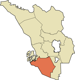
Kuala Langat Municipal Council is the municipal council which administers Kuala Langat District. This agency is under the purview of Selangor state government.

References

  1. "Portal Rasmi PDT Kuala Langat Perutusan Pegawai Daerah Kuala Langat". www2.selangor.gov.my. 2016-06-06. Archived from the original on 2016-09-23.
  2. "Portal Rasmi PDT Kuala Langat Orang Besar Daerah". www2.selangor.gov.my. 2017-01-23. Archived from the original on 2017-02-04.
  3. "Portal Rasmi PDT Kuala Langat Profil Kuala Langat". www2.selangor.gov.my. 2016-08-30. Archived from the original on 2020-10-25.
  4. 1 2 "Population Distribution and Basic Demographic Characteristics, 2010" (PDF). Department of Statistics, Malaysia. Archived from the original (PDF) on 22 May 2014. Retrieved 19 April 2012.
  5. "JPS DAERAH KUALA LANGAT" (PDF). apps.water.gov.my. Archived (PDF) from the original on 2016-08-18. Retrieved 2020-12-25.
  6. "Key Findings of Population and Housing Census of Malaysia 2020" (pdf) (in Malay and English). Department of Statistics, Malaysia. ISBN   978-967-2000-85-3.
  7. "Preserve Kuala Langat North Forest reserve, minister tells Selangor". Free Malaysia Today . October 1, 2020. Archived from the original on 2020-10-09.
  8. "Man transforms scrap metal into 12-metre Transformer". gbtimes.com. Nov 17, 2015. Archived from the original on 2018-02-11.
  9. "Kelana Jaya and Ampang LRT extension services to begin June 30". www.thesundaily.my.