Perak Tengah District

Last updated
Perak Tengah District
Daerah Perak Tengah
Other transcription(s)
   Jawi دائره ڤراق تڠه
   Chinese 中霹雳县
   Tamil பேராக் தெஙஹ்
The Seal of Perak Tengah District Council.png
Perak Tengah highlighted in Perak, Malaysia.svg
Location of Perak Tengah District in Perak
Perak Tengah District
Malaysia location map with districts.svg
Red pog.svg
Perak Tengah District
Location of Perak Tengah District in Malaysia
Coordinates: 4°15′N100°55′E / 4.250°N 100.917°E / 4.250; 100.917
Country Flag of Malaysia.svg  Malaysia
State Flag of Perak.svg  Perak
Seat Seri Iskandar
Largest town Parit
Local area government(s)Perak Tengah District Council
Government
  District officerGhopran Bin Yeop Hamzah [1] [ URL required, verification needed ]
Area
[2]
  Total1,279.46 km2 (494.00 sq mi)
Population
 (2010) [3]
  Total97,530
  Estimate 
(2015) [4]
107,600
  Density76/km2 (200/sq mi)
Time zone UTC+8 (MST)
  Summer (DST) UTC+8 (Not observed)
Postcode
326xx, 328xx-329xx
Calling code +6-05
Vehicle registration plates A
Perak Tengah District Council

Majlis Daerah Perak Tengah
The Seal of Perak Tengah District Council.png
Type
Type
History
Founded1 December 1979
Leadership
President
Mohd Syukri Azaari
District Secretary
Mohd Ainurridha Ahmad Majdi
Motto
Berkhidmat Untuk Rakyat
(Serve the People)
Meeting place
Perak Tengah District Council.jpg
Kompleks MDPT, Seri Iskandar, 32610 Bandar Seri Iskandar, Perak Darul Ridzuan.
Website
www.mdpt.gov.my

Perak Tengah District (Central Perak) is a district in Perak, Malaysia. It is administered by the Perak Tengah District Council, which is based at the town of Seri Iskandar. Parit is however the largest settlement in the area. The district is well known for its historical sites in the Pasir Salak. [5]

Contents

Administrative divisions

Perak Tengah District Map of Perak Tengah District, Perak.svg
Perak Tengah District

Perak Tengah District is divided into 12 mukims, which are: [6] [7]

Demographics

Historical population
YearPop.±%
1991 75,574    
2000 82,153+8.7%
2010 99,854+21.5%
2020 94,573−5.3%
Source: [9]

The following is based on Department of Statistics Malaysia 2010 census. [3]

Ethnic groups in Perat Tengah , 2010 census
Ethnicity PopulationPercentage
Bumiputera 94,66497.0%
Chinese 1,2911.3%
Indian 1,4261.5%
Others1490.2%
Total97,530100%

Federal Parliament and State Assembly Seats


List of Perak Tengah district representatives in the Federal Parliament (Dewan Rakyat)

ParliamentSeat NameMember of ParliamentParty
P69 Parit Muhammad Ismi Mat TaibPerikatan Nasional (PAS)
P73 Pasir Salak Jamaluddin YahyaPerikatan Nasional (PAS)


List of Perak Tengah district representatives in the State Legislative Assembly of Perak

ParliamentStateSeat NameState AssemblymanParty
P69N39 Belanja Khairudin Abu HanipahBarisan Nasional (UMNO)
P69N40 Bota Najihatussalehah AhmadPerikatan Nasional (PAS)
P73N50 Kampong Gajah Zafarulazlan ZanPerikatan Nasional (PAS)

Transportation

Car

Highways 109 and 5 are the main roads in the district, as well as 72 which goes to Parit and 73 to Batu Gajah.

Public transportation

Rail services are not available in the district; the nearest station is in Batu Gajah.

See also

Related Research Articles

<span class="mw-page-title-main">Johor Bahru District</span> District of Malaysia in Johor

The Johor Bahru District is a district located in the southern part of Johor, Malaysia. The heavily suburban/suburbanizing district covers an area of 1,063.97 km2 (410.80 sq mi) and has a population of 1.71 million. The district capital is Johor Bahru City and the administrative capital is Iskandar Puteri City. The district borders Pontian District on the west, Kota Tinggi District on the east, Kulai District on the north and Straits of Johor to the south. The urban centres are divided into the cities of Johor Bahru, Iskandar Puteri and Pasir Gudang.

<span class="mw-page-title-main">Kerian District</span> District of Malaysia in Perak

The Kerian District is an administrative district in Perak, Malaysia. It covers the northwestern corner of Perak, bordering the states of Penang and Kedah to the north; the main town of Parit Buntar is located a mere 37 km (23 mi) southeast of George Town, Penang's capital city. The district is well known for Bukit Merah a popular tourist destination.

<span class="mw-page-title-main">Batu Gajah</span> Town and district capital in Perak, Malaysia

Batu Gajah is the seat of Kinta District, Perak, Malaysia. It is administered by the Batu Gajah District Council, formerly known as Kinta West District Council.

<span class="mw-page-title-main">Kinta District</span> District of Malaysia in Perak

The Kinta District is a district in Perak, Malaysia. It contains the state capital Ipoh. Kinta is the most populated district in Perak and also the seventh most populated district in Malaysia.

<span class="mw-page-title-main">Manjung District</span> District in Perak, Malaysia

The Manjung District, formerly Dindings, is a district in the south-western part of the state of Perak, Malaysia. It is administered by the Manjung Municipal Council, formerly known as Manjung District Council from 1 January 1980 until 31 July 2001. The district is well known for Pangkor Island, an attraction in Perak and the home of the Royal Malaysian Navy (TLDM), Lumut Naval Base and dockyard. Dinding was once part of the British Straits Settlements colony. Seri Manjung is the district's principal urban centre while smaller towns include Lumut town, Sitiawan town, Ayer Tawar, Pantai Remis and Beruas.

<span class="mw-page-title-main">Bota</span> Mukim in Perak Tengah District, Malaysia

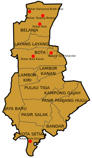
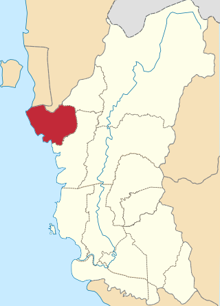
Bota is a mukim in Perak Tengah District, Perak, Malaysia. It comprises two geographical areas: Bota Kiri and Bota Kanan as it is divided by the Perak River. There is a river terrapin breeding center in Bota Kanan. Bota is also well known for its durian fruit. The town has over fifteen mosques.

<span class="mw-page-title-main">Bandar Baharu District</span> District of Malaysia in Kedah

The Bandar Baharu District is a town, district and state assembly constituency at the southernmost end of Kedah, Malaysia. Bandar Baharu is located along the Kedah-Penang–Perak border tripoint, 37 km (23 mi) southeast of George Town, Penang's capital city.

<span class="mw-page-title-main">Larut, Matang and Selama District</span> District of Perak, Malaysia

The Larut, Matang and Selama District is a district of Perak, Malaysia. Taiping is the capital town of this district. Larut, Matang and Selama used to be three small different districts and they merged into one larger district later. Larut, Matang and Selama houses Taiping, Perak's second largest city and former state capital. Other towns in the region include Matang, Kuala Sepetang and Selama. The region borders the state of Kedah on the north, the Kerian District on the northwest, the Hulu Perak and Kuala Kangsar District on the east, and the Manjung District on the south.

<span class="mw-page-title-main">Batu Pahat Municipal Council</span>

Batu Pahat Municipal Council is a local authority which administrates West Batu Pahat District in Johor, Malaysia. This agency is under Johor state government. MPBP are responsible for public health and sanitation, waste removal and management, town planning, environmental protection and building control, social and economic development and general maintenance functions of urban infrastructure. The MPBP main headquarters is located at Jalan Pejabat, Bandar Penggaram, Batu Pahat.

<span class="mw-page-title-main">Kampung Gajah</span>

Kampung Gajah is a town and mukim in Perak Tengah District, Perak, Malaysia.

<span class="mw-page-title-main">BFM 89.9</span> Malaysian radio station

BFM 89.9 is a Malaysian independent business and current affairs-oriented radio station.

<span class="mw-page-title-main">Linau, Johor</span> Parish / Mukim in Johor, Malaysia

Linau Mukim is a mukim located in Batu Pahat district in Johor. Batu Pahat district is divided into 14 parishes, each of which encompasses several villages.

<span class="mw-page-title-main">Kuala Terengganu District</span> District of Malaysia in Terengganu

The Kuala Terengganu District is a district in the state of Terengganu, Malaysia. It covers an area of 210.21 square kilometres, and had a population of 343,284 at the 2010 Census. The district is bordered by Terengganu River which separates Kuala Nerus District in the north and west, Marang District in the south and South China Sea in the east. The capital of this district is Kuala Terengganu.

<span class="mw-page-title-main">Pasir Mas District</span> District of Malaysia in Kelantan

Pasir Mas District is a district (jajahan) in Kelantan, Malaysia. The district covers an area of 614.15 square kilometers and is bordered by the districts of Tumpat District to the north, Tanah Merah District to the south, Kota Bharu District to the east, and the Thai district of Su-ngai Kolok to the west.

<span class="mw-page-title-main">Kuala Kangsar District</span> District in Perak, Malaysia

The Kuala Kangsar District is a district in Perak, Malaysia. Kuala Kangsar shares its borders with Larut, Matang and Selama at the west, Hulu Perak at the north, Gua Musang of Kelantan at the east, Kinta at the south, Perak Tengah and Manjung at the southwest. The seat of this district is the town of Kuala Kangsar.

Pasir Panjang is a state constituency in Perak, Malaysia, that has been represented in the Perak State Legislative Assembly.

References

  1. "Laman Web Pejabat Daerah Dan Tanah Perak Tengah - Pegawai Daerah". pdtseriiskandar.perak.gov.my.
  2. "RTD Perak Tengah 2030" (PDF) (in Malay).
  3. 1 2 "Population Distribution and Basic Demographic Characteristics, 2010" (PDF). Department of Statistics, Malaysia. Archived from the original (PDF) on 22 May 2014. Retrieved 19 April 2012.
  4. "Rancangan Struktur Negeri Perak 2040" (PDF). p. 316. Archived from the original (PDF) on 2018-03-28. Retrieved 2018-03-28.
  5. "Pasir Salak Historical Complex". Malaysia Traveller. Retrieved 2024-02-18.
  6. http://apps.water.gov.my/jpskomuniti/dokumen/Laporan%20Profil%20Daerah%20Perak%20Tengah.pdf [ bare URL PDF ]
  7. "Laman Web Pejabat Daerah Dan Tanah Perak Tengah - Statistik Daerah". pdtseriiskandar.perak.gov.my.
  8. Kampung Gajah is also an autonomous sub-district (daerah kecil). The autonomous sub-district of Kampung Gajah also includes the historical town of Pasir Salak, as well as the nearby communes of Pulau Tiga, Kota Setia, Pasir Panjang Hulu, Jaya Baru and Bandar.
  9. "Key Findings of Population and Housing Census of Malaysia 2020" (pdf) (in Malay and English). Department of Statistics, Malaysia. ISBN   978-967-2000-85-3.