Related Research Articles
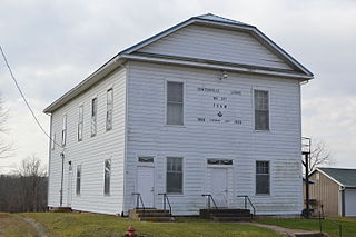
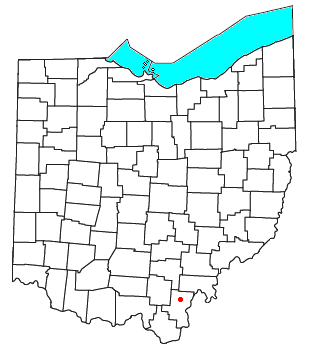
Centerville, also known as Thurman, is a village in Gallia County, Ohio, United States. The population was 87 at the 2020 census. It is part of the rural Point Pleasant micropolitan area. It is located near U.S. Route 35 near the eastern terminus of State Route 279 as the highways parallel each other for about 1/2 mile.
Bidwell is a small unincorporated community in northwestern Springfield Township, Gallia County, Ohio, United States, and is often associated with the nearby community of Porter. Although unincorporated, it has its own ZIP Code of 45614. Bidwell is located eleven miles from the county seat, Gallipolis, at an elevation of 682 feet (208 m).
Kyger Creek High School was a public high school located outside of the village of Cheshire, at the intersection of Little Kyger and Gravel Hill roads in northern Gallia County, Ohio (USA). It replaced Cheshire High School in 1956 and was in turn replaced by River Valley High School in 1992.
Raccoon Creek is a 114-mile-long (183 km) stream that drains parts of five Ohio counties in the United States. It originates in Hocking County, Ohio. It flows through Vinton County and Gallia County and a corner of Meigs County. Its largest tributary, Little Raccoon Creek, arises in Jackson County. The watershed also includes part of Athens County, drained by another tributary, Hewett Fork. The other major tributaries are Elk Fork, located entirely in Vinton County, and Brushy Fork, which is mostly in Vinton County with a small area in Hocking County.
Bloom Junction is an unincorporated community in Scioto County, in the U.S. state of Ohio.
Wallace Mills is an unincorporated community in Scioto County, in the U.S. state of Ohio.
North Eaton is an unincorporated community in Lorain County, in the U.S. state of Ohio.
Rodney is an unincorporated community in Gallia County, in the U.S. state of Ohio.

Northup is an unincorporated community in Gallia County, in the U.S. state of Ohio.
Centerpoint is an unincorporated community in Gallia County, in the U.S. state of Ohio.
Gallia is an unincorporated community in Gallia County, in the U.S. state of Ohio.
Porter is an unincorporated community in Gallia County, in the U.S. state of Ohio.
Evergreen is an unincorporated community in Gallia County, in the U.S. state of Ohio.
Adamsville is an unincorporated community in Gallia County, in the U.S. state of Ohio.
Harrisburg is an unincorporated community in Gallia County, in the U.S. state of Ohio.
Ewington is an unincorporated community in Gallia County, in the U.S. state of Ohio.
Castle Rock is an extinct town in Osage County, in the U.S. state of Missouri. The townsite lies is located on the inside curve of an incised meander of the Osage River. The Castle Rock formation for which it was named lies across the river to the north in Cole County just southeast of Wardsville. The Pikes Camp Wildlife Area lies to the west across the river.
Keystone is an unincorporated community in Bloomfield Township, Jackson County, Ohio, United States. It is located south of the city of Jackson, at the intersection of Franklin Valley Road and Keystone Station Road, at 38°59′17″N82°36′33″W.
Rocky Hill is an unincorporated community in Bloomfield Township, Jackson County, Ohio, United States. It is located southeast of Jackson along U.S. Route 35, next to Winchester at the intersection of C H & D Road and Dixon Run Road, at 38°59′20″N82°32′42″W.
Mabee Corner is an unincorporated community in Hamilton Township, Jackson County, Ohio, United States. It is located west of Oak Hill at the intersection of Bucklick Creek Road and Ohio State Route 139, at 38°54′10″N82°43′16″W.
References
- ↑ U.S. Geological Survey Geographic Names Information System: Kyger
- ↑ History of Gallia County: Containing a Condensed History of the County; Biographical Sketches; General Statistics; Miscellaneous Matters &c. St. Peter's Episcopal Church. 1882. p. 27.
- ↑ Overman, William Daniel (1958). Ohio Town Names. Akron, OH: Atlantic Press. p. 71.
- ↑ U.S. Geological Survey Geographic Names Information System: 1988250
Municipalities and communities of Gallia County, Ohio, United States | ||
|---|---|---|
| Villages |  | |
| Townships | ||
| CDPs | ||
| Other communities | ||
38°58′53″N82°09′18″W / 38.98139°N 82.15500°W
| | This Gallia County, Ohio state location article is a stub. You can help Wikipedia by expanding it. |